Geodetic system identification electromagnetic exploration method and system based on multi-channel orthogonal coding

A technology of orthogonal coding and system identification, which is applied in the field of electrical and electromagnetic prospecting, can solve problems such as joining, and achieve the effect of improving precision and high accuracy

Active Publication Date: 2020-06-02
CENT SOUTH UNIV
View PDF9 Cites 2 Cited by
  • Summary
  • Abstract
  • Description
  • Claims
  • Application Information

AI Technical Summary

Problems solved by technology

[0006] The purpose of the present invention is to provide a multi-channel orthogonal coding-based geodetic system identification electromagnetic survey method and its system for the problem that the exploration accuracy needs to be improved in the prior art. Spread spectrum superposition, and then the receiver uses the orthogonality of the Walsh function to separate into multi-line linearity-independent signals, and solves the ground system impulse response through the multi-channel separated signals, and the accuracy of the ground system impulse response obtained is much higher than It is higher than the single-channel spread spectrum scheme, and a noise factor is added to the calculation process to reduce the influence of noise on the solved earth system impulse response, and provide a basis for obtaining more accurate parameters of the underground medium

Method used


Image

  • Geodetic system identification electromagnetic exploration method and system based on multi-channel orthogonal coding
  • Geodetic system identification electromagnetic exploration method and system based on multi-channel orthogonal coding
  • Geodetic system identification electromagnetic exploration method and system based on multi-channel orthogonal coding

Examples


Embodiment Construction

[0045] The present invention will be further described below in conjunction with examples.

[0046] The present invention provides an electromagnetic prospecting method for geodetic system identification based on multi-channel orthogonal coding. Distribution of physical properties of underground media, interpretation of underground structure and structure, to achieve the purpose of geological exploration.

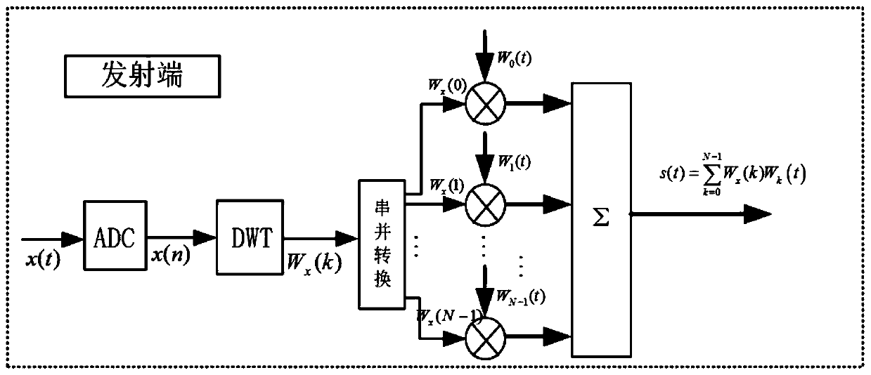
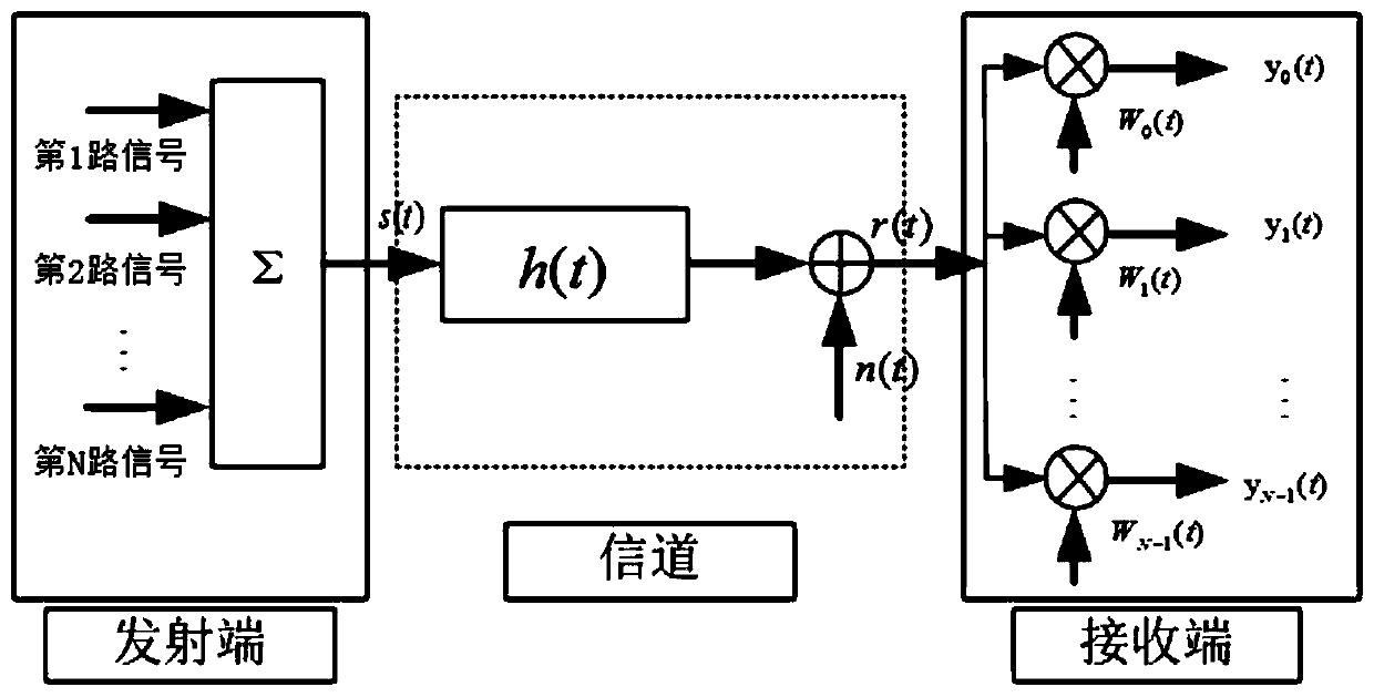
[0047] The multi-channel orthogonal coding-based geodetic system identification electromagnetic surveying method provided by the present invention implements data processing at the transmitting end and the receiving end, and includes the following steps, wherein, steps S1-S4 are performed at the transmitting end, and the steps S5 is executed at the receiving end.

[0048] S1: Obtain an input signal x(t), and sample the input signal based on a preset sampling frequency to obtain a discrete signal.

[0049] Among them, the input signal x(t) can be sine wave, square wave, do...


PUM


Abstract

The invention discloses a geodetic system identification electromagnetic exploration method and a geodetic system identification electromagnetic exploration system based on multipath orthogonal coding. The geodetic system identification electromagnetic exploration method comprises the following steps of: sampling an input signal to obtain a discrete signal; carrying out discrete Walsh transform onN discrete data to obtain coefficients of N Walsh codes; selecting N mutually orthogonal Walsh functions from a Walsh code orthogonal set, and multiplying the Walsh functions by coefficients of the NWalsh codes in a one-to-one correspondence manner to obtain N paths of spread spectrum orthogonal coded signals; combining the N paths of orthogonal coded signals to obtain a total transmitting signal and transmitting the total transmitting signal to a geodetic system; and receiving a total signal transmitted by the geodetic system, performing separation on the total signal by utilizing the N Walsh functions to obtain N paths of receiving signals, and calculating impulse response and noise of the geodetic system by utilizing the N paths of receiving signals. According to the geodetic system identification electromagnetic exploration method and the geodetic system identification electromagnetic exploration system, multipath spread spectrum is carried out on the original input signal, so that the solving precision of the impulse response of the earth system is improved, useful signals and noise are effectively separated, and a basis is provided for acquiring earth medium parameters withhigher accuracy.

Description

technical field [0001] The invention belongs to the technical field of electrical and electromagnetic prospecting, and in particular relates to an electromagnetic prospecting method and system for geodetic system identification based on multi-channel orthogonal coding. Background technique [0002] In electrical and electromagnetic exploration, it is necessary to supply power to the ground (input signal) through grounded wires or ungrounded return wires, and use electric field and / or magnetic field sensors to measure the electric field and / or magnetic field (output signal) of the input signal after it passes through the ground . The input signal can be square wave, pseudo-random wave, step wave, etc., and the output signal is one or several components of vector electromagnetic and / or magnetic field. According to the input signal and the observed electric and / or magnetic field components, the earth system shock response can be calculated, which provides a basis for calculati...

Claims


Application Information

Patent Timeline
Patent Type & Authority Applications(China)
IPC IPC(8): G01V3/08G01V3/38
CPCG01V3/083G01V3/38
Inventor 汤井田杨智肖晓任政勇
Owner CENT SOUTH UNIV
Why Eureka
Try Eureka