Intelligent trolley positioning and navigation method and system based on laser radar and speedometer SLAM

A laser radar and smart car technology, applied in two-dimensional position/channel control, control/adjustment system, vehicle position/route/height control, etc., can solve problems such as limited functions, unsatisfactory positioning effect, and few experimental platforms , to achieve high accuracy, realize the effect of automatic positioning and navigation of the car

Inactive Publication Date: 2020-06-05
ZHONGKAI UNIV OF AGRI & ENG
View PDF8 Cites 18 Cited by
  • Summary
  • Abstract
  • Description
  • Claims
  • Application Information

AI Technical Summary

Problems solved by technology

[0003] As an important branch of robot navigation research, simultaneous localization and map construction (SimultaneousLocalization and Mapping, SLAM) theoretical research is developing rapidly, and it is a hotspot and difficulty in the field of robot research. However, there are few experimental platforms that can be used for outdoor SLAM research.
Some research institutions use simple mobile chassis with odometer, vision, ultrasonic sensors, etc. to build, its functions are very limited, the positioning effect is not ideal, and the stability is not good

Method used


Image

  • Intelligent trolley positioning and navigation method and system based on laser radar and speedometer SLAM
  • Intelligent trolley positioning and navigation method and system based on laser radar and speedometer SLAM
  • Intelligent trolley positioning and navigation method and system based on laser radar and speedometer SLAM

Examples


Embodiment Construction
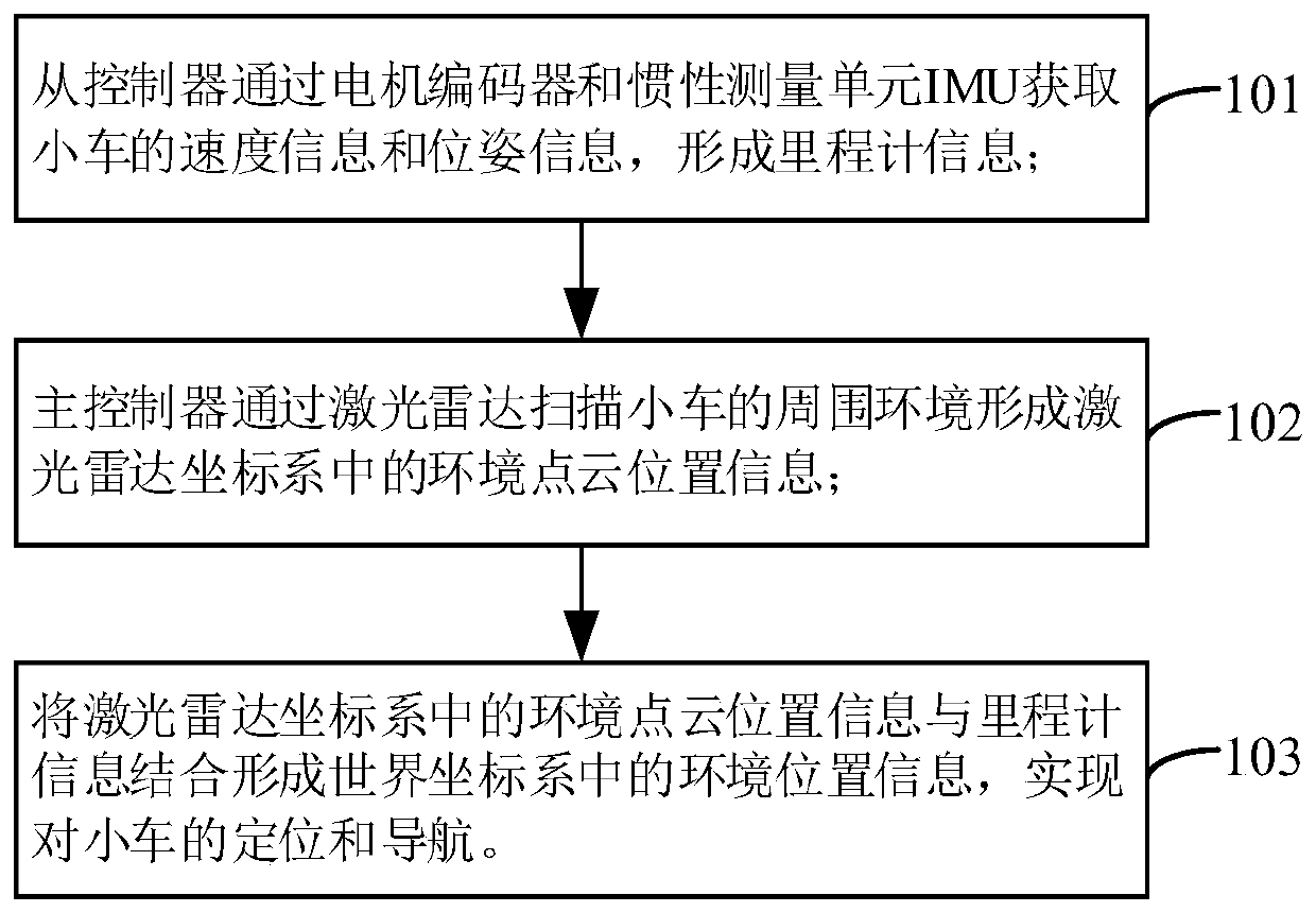
[0041] The overall idea of ​​the technical solution provided by the present invention is as follows:

[0042] For the smart car to realize the positioning and navigation function in an unknown environment, it is necessary to obtain the location information of the surrounding environment based on the various sensors on the car to realize the SLAM function. The construction of the environmental map based on SLAM technology is the key to the movement of the car, which has an important theory. Analysis and practical application of research value.

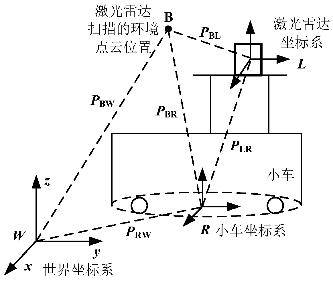
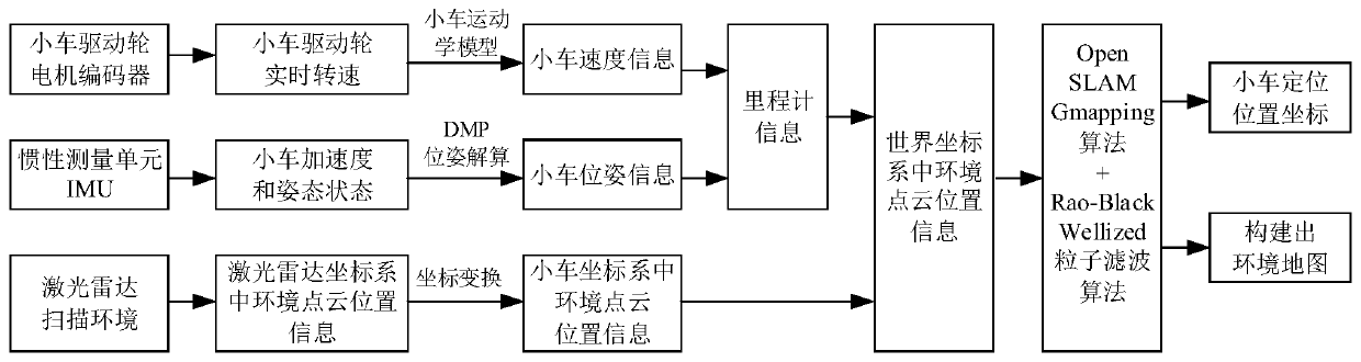
[0043] According to the positioning and navigation requirements of the moving car, the present invention constructs an intelligent car positioning and navigation system based on laser radar and odometer SLAM. According to the conversion relationship between the relevant coordinate systems, the point cloud position data of the surrounding environment of the car scanned by the lidar is converted into the world coordinate system, and then ...


PUM


Abstract

The invention discloses an intelligent trolley positioning and navigation method based on a laser radar and a speedometer SLAM, and the method comprises the following steps: a slave controller acquires the speed information and pose information of a trolley through a motor encoder and an inertial measurement unit IMU so as to form speedometer information; a main controller scans the surrounding environment of the trolley through the laser radar to form environmental point cloud position information in a laser radar coordinate system; and the environmental point cloud position information in the laser radar coordinate system is combined with the speedometer information to form environmental position information in a world coordinate system so as to realize positioning and navigation of thetrolley. The invention further provides an intelligent trolley positioning and navigation system based on the laser radar and the odometer SLAM. According to the invention, an accurate environment mapcan be constructed in the moving environment of the trolley, and the target position of trolley navigation can be set on the constructed environment map through the upper computer, so that the automatic positioning and navigation functions of the intelligent trolley are realized, and the accuracy is relatively high.

Description

technical field [0001] The invention relates to the technical field of artificial intelligence, in particular to a method and system for positioning and navigating an intelligent car based on laser radar and odometer SLAM. Background technique [0002] With the continuous development and progress of artificial intelligence technology, intelligent mobile devices with certain independent positioning and navigation capabilities, such as service robots, drones, and automatic guided vehicles, have gradually been applied to home services, agricultural production, medical services, and catering. service, military and entertainment fields. At present, smart mobile cars are increasingly being used for smart inspections in greenhouses, poultry farms and other places, as well as smart operations such as family sweeping and restaurant delivery. It can be seen that the intelligent mobile car that can locate and navigate independently has important practical value and broad application p...

Claims


Application Information

Patent Timeline
Patent Type & Authority Applications(China)
IPC IPC(8): G05D1/02
CPCG05D1/0257G05D1/0274G05D2201/0216
Inventor 付根平朱立学张世昂黄伟锋吴震龙陈天赐杨尘宇
Owner ZHONGKAI UNIV OF AGRI & ENG
Why Eureka
Try Eureka