
Local path planning algorithm for unmanned vehicle

A technology for unmanned vehicles and local path planning, applied in vehicle position/route/altitude control, road network navigator, two-dimensional position/channel control, etc., can solve problems such as complex algorithms and large calculation requirements

Active Publication Date: 2020-06-16
南京维思科汽车科技有限公司
View PDF3 Cites 22 Cited by
  • Summary
  • Abstract
  • Description
  • Claims
  • Application Information

AI Technical Summary

Problems solved by technology

This requires trajectory prediction for dynamic obstacles, and at the same time, speed sampling is performed on multiple planned trajectories for dynamic collision detection, in order to obtain optimal trajectory and speed planning. The disadvantage is that the algorithm is complex and the amount of calculation is very large.

Method used


Image

  • Local path planning algorithm for unmanned vehicle
  • Local path planning algorithm for unmanned vehicle
  • Local path planning algorithm for unmanned vehicle

Examples


Embodiment Construction

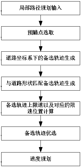
[0176] A local path planning algorithm for unmanned vehicles proposed by the present invention will be described in detail below in conjunction with the accompanying drawings. In the description of the present invention, it should be understood that the orientation or positional relationship indicated by the terms "left", "right", "upper", "lower", "bottom" etc. is based on the orientation or positional relationship shown in the drawings The positional relationship is only for the convenience of describing the present invention and simplifying the description, and does not indicate or imply that the referred device or element must have a specific orientation, be constructed and operated in a specific orientation, "first", "second", etc. It does not indicate the importance of components, so it should not be construed as limiting the present invention. The specific dimensions used in this embodiment are only for illustrating the technical solution, and do not limit the protectio...


PUM


Abstract

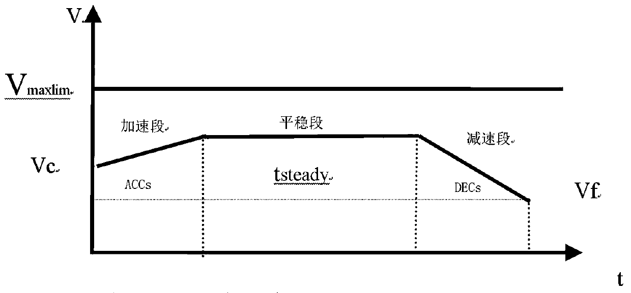
The invention discloses a local path planning algorithm for an unmanned vehicle. The algorithm comprises the following steps: inputting parameters required by local path planning; selecting a previewpoint; performing trajectory planning based on the road coordinate system to generate a basic trajectory; matching the basic track with a road shape to generate an alternative track; calculating a speed limit value based on the alternative track and a corresponding speed limit position; optimizing the alternative trajectories to obtain trajectories executed by the unmanned vehicle, called optimaltrajectories; and planning the speed of the unmanned vehicle based on the optimal trajectory. According to the local path planning algorithm, the planning failure in a complex road is avoided, the local path planning in the complex environment is simplified, and the driving behavior is close to the driving behavior of people. The algorithm can effectively process the influence of static obstacles,dynamic objects, traffic signal lamps, various traffic facilities of a speed limit belt and the like on the unmanned vehicle in real time in a complex urban road environment.

Description

technical field [0001] The invention belongs to the technical field of unmanned driving path planning, in particular to a local path planning algorithm for unmanned vehicles. Background technique [0002] Unmanned vehicles are a class of vehicles that can autonomously complete driving tasks in complex environments on the road. Unmanned driving control is mainly divided into the following parts: 1) Environmental perception module, which perceives and understands external environmental information through sensors such as cameras, laser radars, and millimeter-wave radars, such as static and dynamic obstacles such as vehicles and pedestrians on the road, and lane lines , traffic lights, traffic signs, etc. 2) Positioning module, which uses satellite navigation, inertial navigation, SLAM Carry out high-precision positioning to obtain vehicle position, speed, heading, and driving curvature. 3) High-precision maps provide all information on the road for driverless driving. 4) T...

Claims


Application Information

Patent Timeline
IPC IPC(8): G01C21/34G05D1/02
CPCG01C21/3492G05D1/021
Inventor 谢书港张宇
Owner 南京维思科汽车科技有限公司
Learn More