Intelligent geotechnical engineering parameter three-dimensional analysis and evaluation system and method based on voxler software

A geotechnical engineering and evaluation system technology, applied in geometric CAD, design optimization/simulation, etc., can solve problems such as strict constraints, frequent interactions, and greater influence of subjective factors

Inactive Publication Date: 2020-06-26
南京智慧岩土工程技术研究院有限公司
View PDF1 Cites 8 Cited by
  • Summary
  • Abstract
  • Description
  • Claims
  • Application Information

AI Technical Summary

Problems solved by technology

2D and 3D integrated profile drawing of engineering geology requires frequent interaction of data in 3D systems and 2D AutoCAD. Using traditional methods, these files need to be converted into intermediate formats, and then processed after importing, the interactivity is too poor;
[0005] (2) The workload of drawing is heavy and the efficiency is low
In the traditional section drawing method, geometric projection, intersection and drawing are all done manually, the working method is relatively primitive, and is greatly affected by subjective factors
The calculation results are managed separately from the design drawings, the data are scattered, and the statistical work is inefficient;
[0006] (3) It is cumbersome to modify the result drawings
Whether it is the change of stratification data of rock and soil layer, or the screening statistics of relevant in-situ test and geotechnical test parameters, it will cause corresponding changes in all processes of profile drawing, resulting in relatively frequent repetitive work;
[0007] (4) Calculation results are not intuitive enough
In-situ test, geotechnical test data statistics, pile foundation, foundation pit parameter calculation process and results are limited in a single CAD system, that is, it cannot intuitively reflect the spatial variation of the section in each rock and soil layer, and the degree of visualization is low
[0008] (5) The post-marking is cumbersome
At present, 3D geological modeling technology is still mainly used in mining, energy and other technical fields, such as GOCAD, EarthVision, Geocom, etc., and there are few researches and applications in the field of geotechnical engineering investigation technology; and some modeling systems are huge and complex to operate , it is difficult for technical personnel to master; the constraints are too strict, and the editing workload is relatively large;
[0011] (2) Horizontal geological profile technology is not yet mature
The current 3D slicing technology is still dominated by vertical geological section technology, which can only describe the stratum distribution on a certain vertical plane, and cannot effectively reflect the overall distribution of rock and soil layers at different elevations or different target horizons. Provide comprehensive and effective technical support for survey, design, construction, etc.;
[0012] (3) Lack of 3D data modeling standards for geotechnical engineering surveys, poor sharing
In essence, it still simply connects the formation lines between two boreholes with a spline curve, and does not conduct a comprehensive analysis based on the relevant in-situ test, geotechnical test and other data that can be reasonably used;
[0013] (4) The simulation of 3D geological surface lacks timeliness and continuity
However, traditional databases do not include accurate geological attribute information
At the same time, since the boundary of the stratum is usually the boundary of the working area, not the natural boundary of the engineering stratum, the change of the 2D map will cause the 3D geological body to be updated, and it is difficult to ensure the timeliness and continuity of the 3D geological body results

Method used


Image

  • Intelligent geotechnical engineering parameter three-dimensional analysis and evaluation system and method based on voxler software
  • Intelligent geotechnical engineering parameter three-dimensional analysis and evaluation system and method based on voxler software
  • Intelligent geotechnical engineering parameter three-dimensional analysis and evaluation system and method based on voxler software

Examples


Embodiment 1

[0213] The following is combined through specific embodiments Figure 1~16 The technical scheme of the present invention will be described in detail.

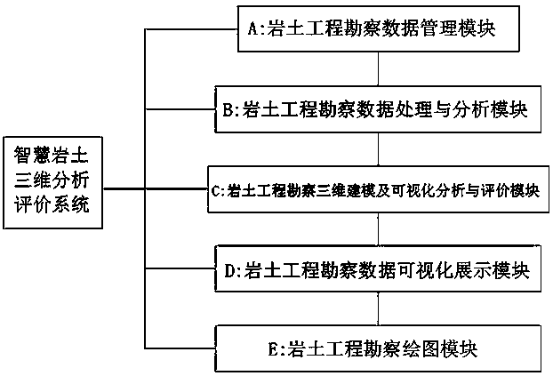
[0214] Such as figure 1 As shown, the intelligent geotechnical engineering parameter three-dimensional analysis and evaluation system and method based on Voxler software of the present invention, the system takes geotechnical engineering survey data as the core, including geotechnical engineering survey data management module A, geotechnical engineering survey Data processing and analysis module B, geotechnical engineering survey three-dimensional modeling and geotechnical parameter visualization analysis and evaluation module C, geotechnical engineering survey data visualization display module D, and geotechnical engineering survey drawing and data output module E.

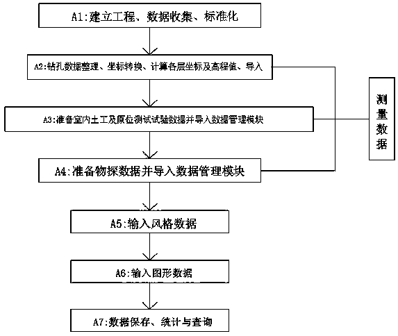
[0215] Such as figure 2 As shown, the geotechnical engineering survey data management module A mainly realizes the management of geotechnical engineering survey data...


PUM


Abstract

The invention discloses an intelligent geotechnical engineering parameter three-dimensional analysis and evaluation system and method based on voxler software. The system takes geotechnical engineering investigation data as a core; the evaluation system comprises a geotechnical engineering investigation data management module, a geotechnical engineering investigation data processing and analysis module, a geotechnical engineering investigation three-dimensional modeling and geotechnical parameter visual analysis and evaluation module, a geotechnical engineering investigation data visual display module and a geotechnical engineering investigation drawing and data output module. Each module has a set of complete new method and a data processing, analysis and evaluation process. According tothe invention, three-dimensional comprehensive analysis and evaluation are carried out on drilling sampling, in-situ testing, geotechnical testing and geophysical prospecting data. The three-dimensional modeling technology constructed by the system is easy to learn and use and high in precision, better conforms to the real stratum condition, and can be better applied to three-dimensional analysisand evaluation of geotechnical engineering investigation parameters.

Description

Technical field [0001] The invention relates to the technical field of geotechnical engineering survey, in particular to a geotechnical engineering parameter data processing and three-dimensional analysis evaluation system based on voxler software. Background technique [0002] Geotechnical engineering survey involves engineering geological surveying and mapping, drilling sampling, in-situ testing, indoor geotechnical testing, physical and chemical exploration, etc. It is widely used in various stages of engineering planning, design, construction and maintenance. The purpose of geotechnical engineering survey is to find out the engineering geology, hydrogeology, environmental geology and other conditions of various engineering sites, comprehensively evaluate the sites and various geological issues related to them, analyze and predict that under the action of engineering construction, there may be The changes in geological conditions and the impact on the design and construction, ...

Claims


Application Information

Patent Timeline
Patent Type & Authority Applications(China)
IPC IPC(8): G06F30/20G06F30/13G06F30/12
Inventor 饶开永董平李俊才曹晶晶林春明刘松玉贺锦美张鹏
Owner 南京智慧岩土工程技术研究院有限公司
Why Eureka
Try Eureka