Continuous depth reference surface construction method

A construction method and datum technology, applied in design optimization/simulation, etc., can solve the problem of low accuracy of depth datum, and achieve accurate and easy-to-implement, high-precision real-time water depth data and chart data acquisition effect

Pending Publication Date: 2020-07-03
TIANJIN UNIV
View PDF2 Cites 3 Cited by
  • Summary
  • Abstract
  • Description
  • Claims
  • Application Information

AI Technical Summary

Problems solved by technology

With the rapid development of port construction, large-scale ships and shipping economy, the problem of low accuracy of the existing depth datum has increasingly become a bottleneck problem restricting marine surveying and mapping services in modern shipping

Method used


Image

  • Continuous depth reference surface construction method
  • Continuous depth reference surface construction method
  • Continuous depth reference surface construction method

Examples


Embodiment

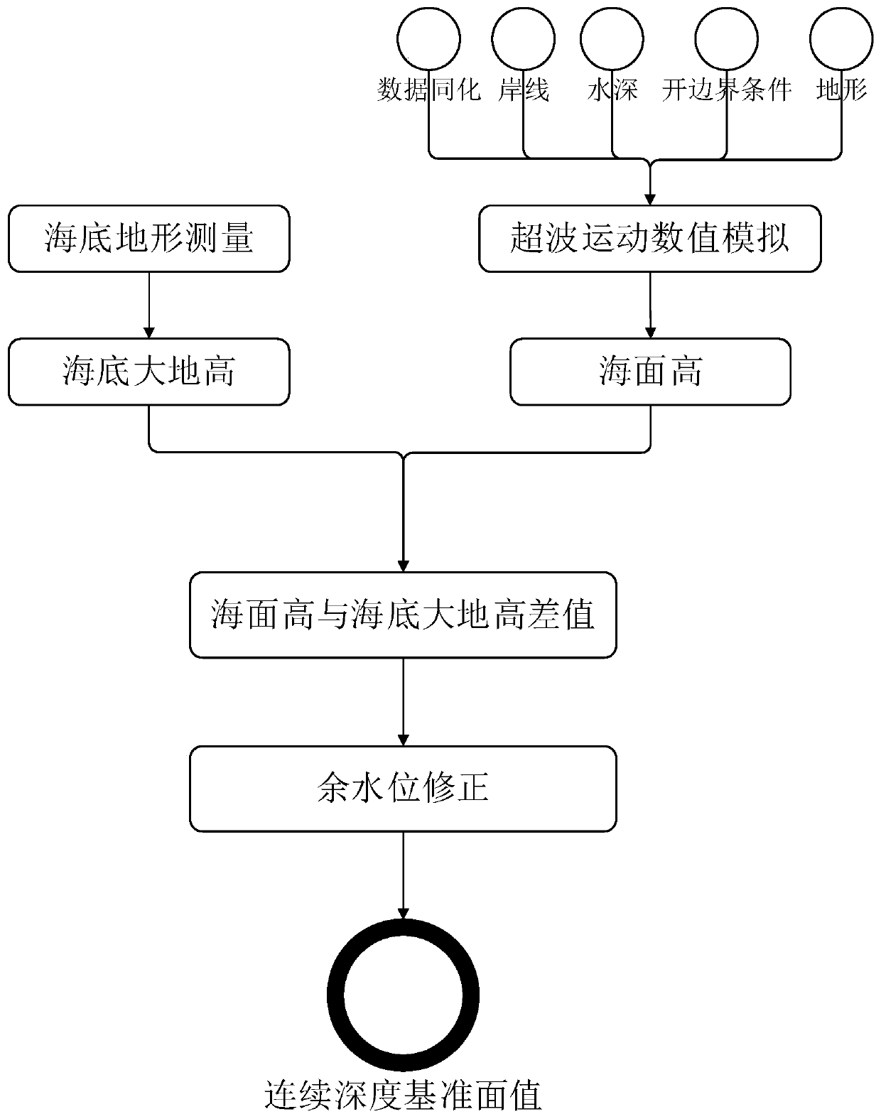
[0035] Step 1, use the seabed topographic measurement system to obtain the seabed geodetic height, combined with the precise positioning and attitude determination system, obtain the seabed geodetic height; obtain the open boundary conditions, water depth and data that need to be assimilated in the survey area, and use the ocean numerical model to perform tidal wave numerical simulation, Obtain the high water level, and correct the obtained data through the correction of the residual water level. In the above scheme, the seabed geodetic height is obtained through the seabed topography measurement system, and its implementation method can be carried out by unmanned boats carrying the seabed topography measurement system for data acquisition, and its seabed topography measurement can also be used in more efficient navigable water depths Efficiency and navigation water depth intelligent service, providing real-time high-precision dynamic water depth.

[0036] In order to improve ...


PUM


Abstract

The invention discloses a continuous depth datum plane construction method, which comprises the following steps of: firstly, obtaining a seabed geodetic height based on a reference ellipsoidal surfacethrough seabed topographic survey, and obtaining an average sea surface height through an arithmetic mean value of sea level changes within a certain period of time; a sea numerical model is used forcarrying out tide wave motion numerical simulation on the sea surface height, the sea surface height is obtained, then residual water level correction is carried out, finally, the difference value between the seabed geodetic height and the sea surface height is calculated, and a depth reference surface value is obtained. The method is reliable in quality and easy to operate, the continuous depthreference surface value of the positive and negative measurement area can be more accurately reflected, the calculated continuous depth reference surface value is higher in precision, and the method has higher use value.

Description

technical field [0001] The invention relates to the technical field of marine information collection, in particular to a method for constructing a continuous depth reference plane. Background technique [0002] The traditional depth datum is obtained from the tide gauge data of the tide gauge station using the harmonic analysis method, and is calculated using the 13-part tide model according to the hydrographic survey specification. Therefore, relative to the value of the average sea surface, the depth datum is only a sampling of the real surface shape datum at a specific point, which is discrete, jumping and discontinuous, and has regional characteristics. With the rapid development of port construction, large-scale ships and shipping economy, the problem of low accuracy of the existing depth datum has become more and more a bottleneck problem restricting the service of marine surveying and mapping in modern shipping. In addition, long-distance fast hydrographic surveying ...

Claims


Application Information

Patent Timeline
Patent Type & Authority Applications(China)
IPC IPC(8): G06F30/20
Inventor 张安民胡英俊张豪张佳丽刘帅徐唐进
Owner TIANJIN UNIV
Why Eureka
Try Eureka