Three-dimensional reconstruction method for aerial images of unmanned aerial vehicle based on deep learning

A deep learning and three-dimensional reconstruction technology, applied in the field of computer vision, can solve the problems of large amount of calculation, low precision, and difficult to reconstruct dense maps, so as to improve the speed and integrity of reconstruction, reduce the occupation of memory, and achieve high reconstruction accuracy. Effect

Pending Publication Date: 2020-07-28
NANJING UNIV OF AERONAUTICS & ASTRONAUTICS
View PDF4 Cites 18 Cited by
  • Summary
  • Abstract
  • Description
  • Claims
  • Application Information

AI Technical Summary

Problems solved by technology

Due to the large amount of calculation, low precision, long time consumption and high hardware equipment requirements of SLAM, it is difficult to quickly realize dense map reconstruction

Method used


Image

  • Three-dimensional reconstruction method for aerial images of unmanned aerial vehicle based on deep learning
  • Three-dimensional reconstruction method for aerial images of unmanned aerial vehicle based on deep learning
  • Three-dimensional reconstruction method for aerial images of unmanned aerial vehicle based on deep learning

Examples


Embodiment Construction

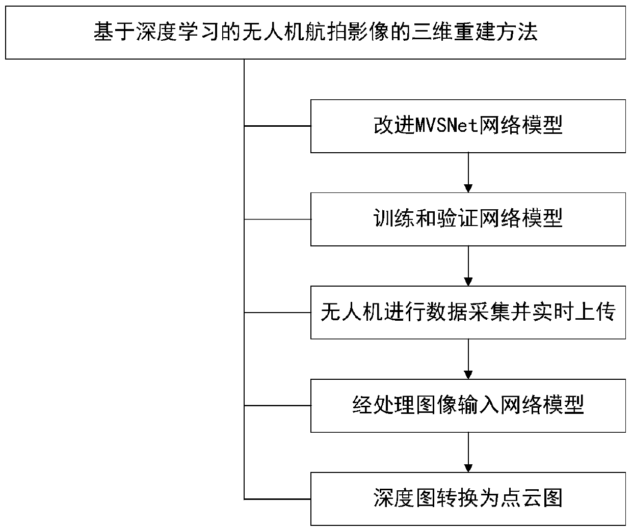
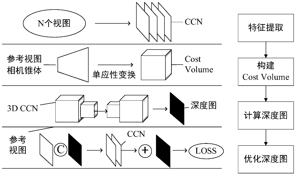
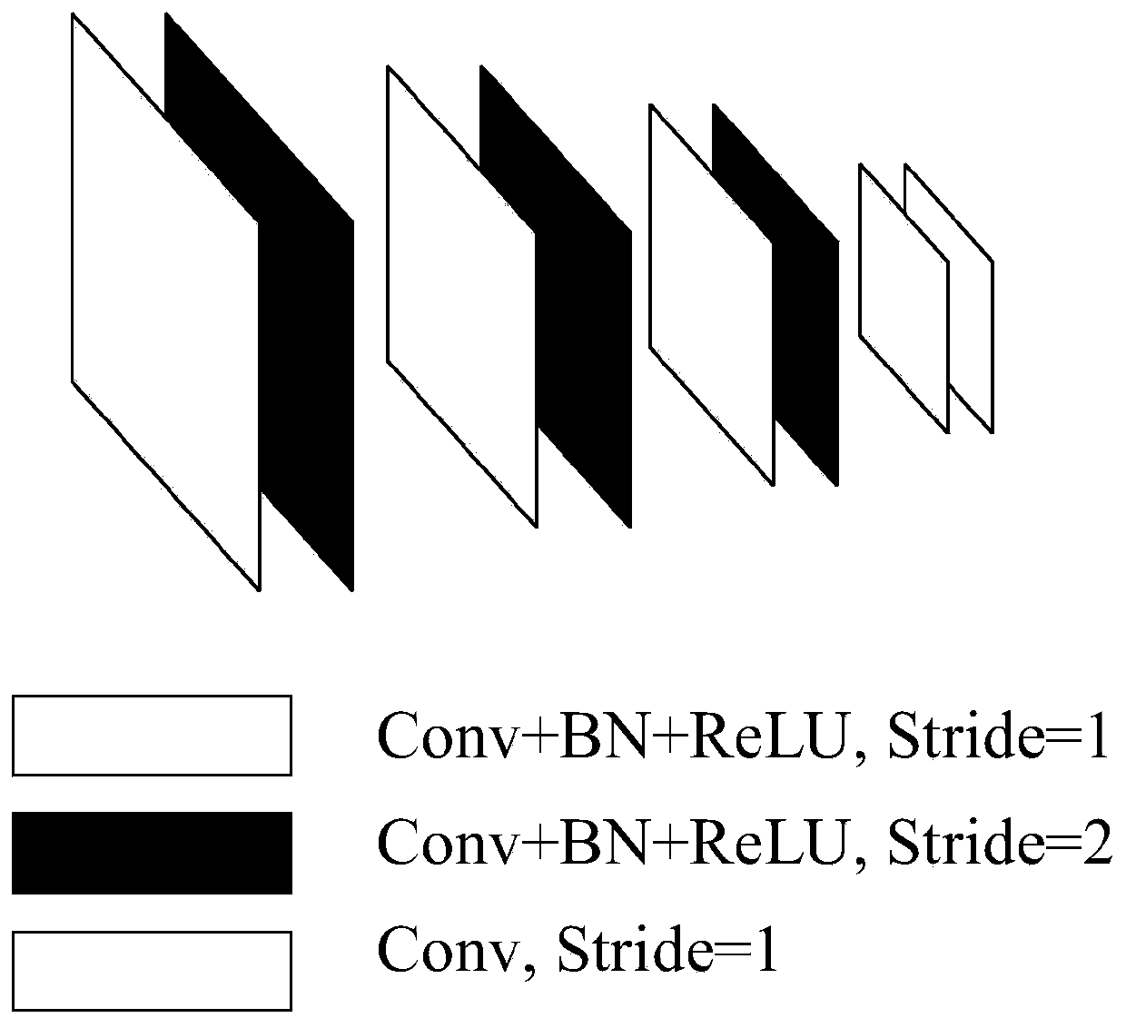
[0054] The invention improves the MVSNet network model so that it can be better applied to the unmanned aerial vehicle carrier. According to the BlendedMVS data set, the improved network model is trained, and the network weight parameters are updated after several iterations to select the optimal network model parameters. Using multiple cameras on the UAV for data collection, which includes uploading the collected aerial image data containing location information in real time, the image sequence is formatted and input to the end-to-end neural network model to obtain the relevant depth map. Using the depth map fusion algorithm technology, the depth map is converted into a 3D point cloud map for storage.

[0055] The present invention will be described in detail below in conjunction with the accompanying drawings and specific implementation steps.

[0056] Such as figure 1 Shown, the concrete implementation method of the present invention is as follows:

[0057] S1. Improve t...


PUM


Abstract

The invention discloses a three-dimensional reconstruction method for aerial images of an unmanned aerial vehicle based on deep learning, and belongs to the technical field of computer vision. On thebasis of an existing three-dimensional reconstruction method, the three-dimensional reconstruction method of the aerial image of the unmanned aerial vehicle based on deep learning is provided according to the multi-view geometry theory. The method comprises the following steps: S1, improving an MVSNet network model; s2, training the improved network model by using the Blended MVS data set; s3, performing data acquisition by using a plurality of cameras on the unmanned aerial vehicle; s4, performing format processing on the picture data acquired in the step S3; and S5, converting the depth mapinto a 3D point cloud map by adopting a depth map fusion algorithm technology, and storing the 3D point cloud map. According to the method, an MVS (Multi-View Stereo) algorithm combined with a deep learning thought is adopted, and the MVS is used as an estimation method for carrying out dense representation on the overlapped images, so that the method has the advantage of high reconstruction precision. Meanwhile, the reconstruction rapidity and integrity are effectively improved by utilizing deep learning.

Description

technical field [0001] The invention relates to a three-dimensional reconstruction method for aerial images of unmanned aerial vehicles based on deep learning, and belongs to the technical field of computer vision. Background technique [0002] Unmanned Aerial Vehicle (UAV) is widely used in military and civilian fields because of its high flexibility, low cost, strong anti-interference ability, and little constraint by ground terrain. In addition, UAVs can cruise below the clouds, so they can quickly obtain aerial images with high spatial resolution, which provides an effective way for image-based 3D reconstruction. [0003] Existing 3D reconstruction techniques based on UAV aerial images can be divided into two categories: [0004] One is the traditional aerial survey method. This type of method is widely used in the photogrammetry of large-scale track rules. However, the traditional aerial survey method has complex production process, low production efficiency, high wo...

Claims


Application Information

Patent Timeline
Patent Type & Authority Applications(China)
IPC IPC(8): G06T17/20G06N3/04G06N3/08
CPCG06T17/20G06N3/08G06N3/045
Inventor 彭聪江清芳孙蕊龚华军
Owner NANJING UNIV OF AERONAUTICS & ASTRONAUTICS
Why Eureka
Try Eureka