Farmland soil organic carbon spatio-temporal data acquisition method

An acquisition method and technology of spatiotemporal data, applied in the field of digital agricultural soil quality monitoring, can solve problems such as time-consuming, labor-intensive and expensive, difficult soil morphology and properties, quantitative description, etc. The effect of technical blanks

Active Publication Date: 2020-08-04
HENAN UNIV OF URBAN CONSTR
View PDF4 Cites 2 Cited by
  • Summary
  • Abstract
  • Description
  • Claims
  • Application Information

AI Technical Summary

Problems solved by technology

[0002] Due to the complexity of soil morphology and evolution process, it is difficult to quantitatively describe soil morphology and properties, and the quantitative description of spatial variation characteristics and spatial correlation is more complicated. How to quickly obtain the key soil information required has become a challenge for scientific researchers. Hot Issues
[0003] In the field of soil monitoring, the current large-scale sampling survey process is very cumbersome. It is necessary to go to the specific location of the sample point to collect samples and bring the sample back to the laboratory for further analysis, which requires a lot of manpower and time. However, the cost of manpower and time is greatly increased, and large-scale soil quality surveys are usually carried out at intervals of 10 years or more. It takes 1-3 years to complete a large-scale survey, and the efficiency of data acquisition is very low. Analysis is highly dependent, time-consuming, labor-intensive and costly, and its practicability is limited due to its low work efficiency. It is difficult to meet the needs of today's fast-growing modern agriculture, especially with the development of digital agriculture, access to agricultural big data Severely insufficient capacity and urgent need to develop technologies that can quickly obtain agricultural soil attribute data

Method used


Image

  • Farmland soil organic carbon spatio-temporal data acquisition method
  • Farmland soil organic carbon spatio-temporal data acquisition method
  • Farmland soil organic carbon spatio-temporal data acquisition method

Examples


Embodiment Construction

[0031] The specific implementation manners of the present invention will be further described in detail below in conjunction with the accompanying drawings.

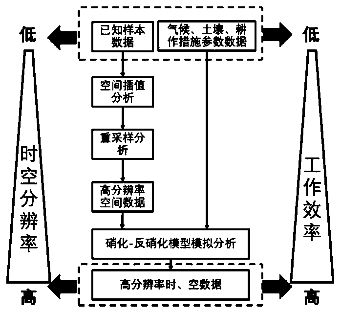
[0032] The present invention designs a method for acquiring farmland soil organic carbon spatio-temporal data, which is used to obtain the change of soil organic carbon density at each position in the target area with time series, such as figure 1 As shown, the following steps A to E are included.

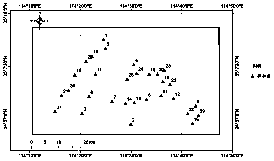
[0033] Step A. For each sample point with a preset number and preset distribution in the target area, obtain the soil organic carbon density at the sample point location, and then proceed to step B.

[0034] Since the soil type, farming system, land use type, and climate characteristics within a diameter of 100 meters around the sample point are consistent with the attribute information of the sample point, the sample point can represent the surrounding soil fertility characteristics; therefore, in practical applications, the...


PUM


Abstract

The invention relates to a farmland soil organic carbon spatio-temporal data acquisition method. Interpolation and resampling analysis are performed by adopting a small amount of sample data to obtainmore spatial sample point data, so that the spatial resolution can be quickly and greatly improved; by performing time dimension simulation analysis on the high-spatial-resolution sample point data,the time resolution is far higher than that of spatial sample point data obtained by traditional sampling investigation, and the spatial-temporal-scale high-resolution sample point data can be quicklyobtained; according to the whole design method, the data acquisition working efficiency can be greatly improved; according to a traditional investigation method, a large amount of manpower needs to be input for field sampling investigation and indoor test analysis, and the time cost is high; space-time scale expansion can be performed by utilizing a small amount of sample data in a single period,soil sample point data with higher space-time resolution can be obtained, data support is provided for digital agriculture big data analysis, and the technical blank that current data is difficult toobtain is filled up.

Description

technical field [0001] The invention relates to a method for acquiring farmland soil organic carbon spatiotemporal data, belonging to the technical field of digital agricultural soil quality monitoring. Background technique [0002] Due to the complexity of soil morphology and evolution process, it is difficult to quantitatively describe soil morphology and properties, and the quantitative description of spatial variation characteristics and spatial correlation is more complicated. How to quickly obtain the key soil information required has become a challenge for scientific researchers. Hot Issues. [0003] In the field of soil monitoring, the current large-scale sampling survey process is very cumbersome. It is necessary to go to the specific location of the sample point to collect samples and bring the sample back to the laboratory for further analysis, which requires a lot of manpower and time. However, the cost of manpower and time is greatly increased, resulting in lar...

Claims


Application Information

Patent Timeline
Patent Type & Authority Applications(China)
IPC IPC(8): G06K9/62G06K9/36G06Q50/02
CPCG06Q50/02G06V10/20G06F18/2415
Inventor 赵占辉杨锋张宏敏鲁春阳李军杰杨甲李会杰
Owner HENAN UNIV OF URBAN CONSTR
Why Eureka
Try Eureka