A new method and system for topographic surveying and mapping of mobile superstation instrument mode

A mobile superstation and topographic surveying and mapping technology, applied in the fields of surveying and mapping, geographic information science, and surveying, can solve problems such as difficulty in obtaining coordinates, and achieve the effect of improving efficiency, simple method and strong reliability.

Active Publication Date: 2021-01-08
GUANGXI HUALAN GEOTECHNICAL ENG CO LTD
View PDF7 Cites 0 Cited by
  • Summary
  • Abstract
  • Description
  • Claims
  • Application Information

AI Technical Summary

Problems solved by technology

The characteristic of this method is that the coordinates of the instrument at the measuring station must be obtained, and the places where the total station is set are mostly for visual observation of places where satellite signals are not good, so the coordinates of the measuring station are often blocked by surrounding objects and difficult to obtain

Method used


Image

  • A new method and system for topographic surveying and mapping of mobile superstation instrument mode
  • A new method and system for topographic surveying and mapping of mobile superstation instrument mode
  • A new method and system for topographic surveying and mapping of mobile superstation instrument mode

Examples


Embodiment 1

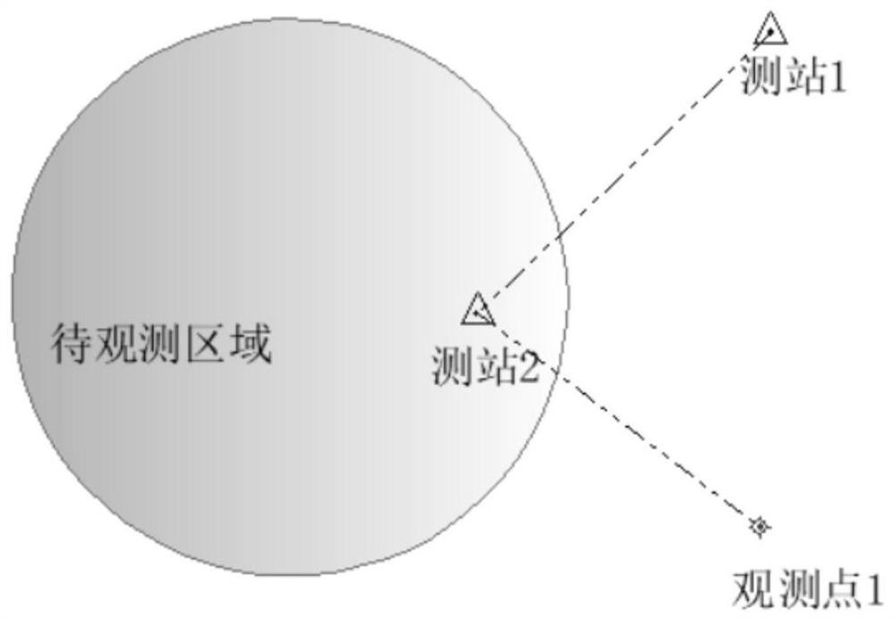
[0036] see figure 2 , is a schematic diagram of the station layout of the present invention, a new method of topographic surveying and mapping of a mobile super station instrument mode of the present invention is to first survey and map the observation point 1 and observation point 2, then back-calculate the position of the station, and then observe the area to be observed.

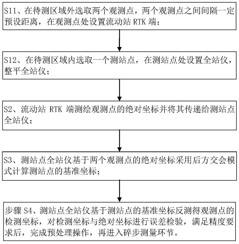
[0037] see image 3 , a new method for mobile super station instrument mode topographic surveying and mapping of the present embodiment, comprising the following steps:

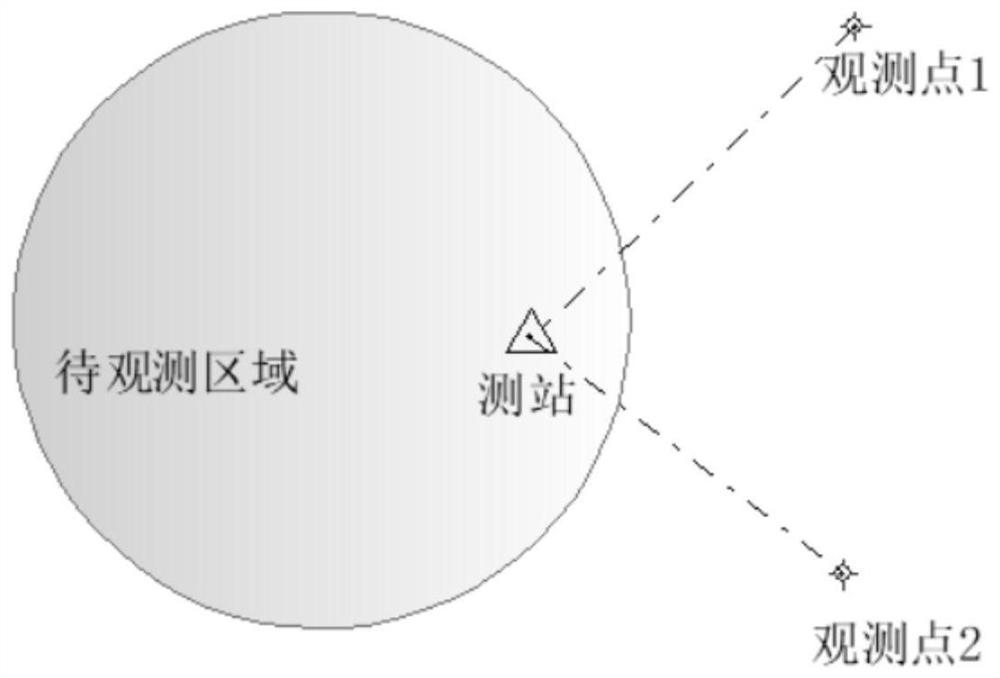
[0038] Step S1, setting up the instrument: select more than two observation points outside the area to be measured, set the RTK terminal of the rover at the observation point; and, select a station in the area to be measured, set a total station at the station, and Flat total station.

[0039] In step S1, the rover can be set first, the total station can also be set first, or both can be set at the same time. see figure 1 , taking s...

Embodiment 2

[0066] On the basis of Embodiment 1, this Embodiment 2 provides a specific example.

[0067] A new method for mobile super-station instrument mode terrain surveying and mapping of the present embodiment comprises the following steps:

[0068] Step 1) Select two observation points with a certain distance between flat terrain and no obstructions, and map their absolute coordinates.

[0069] Flat terrain means that the total station can observe the effective part of the RTK end of the rover. No obstruction means that the position of the rover can obtain an effective fixed solution. The distance between the two observation points is 100 meters, and the coordinates are (2500000, 2500000, 0), (2500000, 2500100, 0), the measuring point time is about 3 minutes.

[0070] Step 2) Set up and level the total station.

[0071] The total station is directly leveled at a place where it is convenient to fix the equipment and can visually see the above two points. The height of the record in...

Embodiment 3

[0080] On the basis of Embodiment 1 or Embodiment 2, the following will describe the topographic surveying and mapping system of the mobile super-station instrument mode of this embodiment. Please refer to Embodiment 1 or Embodiment 2 for specific description.

[0081] see Figure 9 , the mobile super-station instrument mode terrain surveying and mapping system of the present embodiment includes the following contents:

[0082] Set the instrument module: it is used to select two or more observation points outside the area to be measured, and set the RTK terminal of the rover at the observation points; flat total station;

[0083] Surveying and mapping module: used for surveying and mapping the absolute coordinates of observation points at the RTK terminal of the rover and transferring them to the total station at the station;

[0084] Calculation module: used for the total station at the station to calculate the reference coordinates of the station based on the absolute coor...


PUM


Abstract

The invention discloses a novel topographic surveying and mapping method for a mobile super-station instrument mode, and belongs to the technical field of measurement. According to the novel topographic surveying and mapping method for the mobile super-station instrument mode, a measurement station is determined by resection of two observation points, and multi-point directional inspection is carried out on the measurement station, so that the precision of position initialization of the measurement station is ensured, precision reduction caused by continuous supporting points in the prior artis avoided, centering operation is not needed, simplification and high efficiency of initialization of the measurement station are realized, and meanwhile, the quality of surveying and mapping resultsis improved.

Description

technical field [0001] The invention relates to the field of surveying technology, to the field of surveying and mapping and geographic information science, in particular to a new method for topographic surveying and mapping in a mobile superstation instrument mode. Background technique [0002] Total station is one of the most commonly used equipment in surveying and mapping geographic information units. With the emergence and improvement of RTK equipment, the combination of total station and RTK has emerged as super station equipment. Revolutionary equipment has appeared, but there are certain limitations in its popularization and use, especially the station location of the super station instrument. If there is no good satellite signal, the advantages of the equipment cannot be brought into play. [0003] see figure 1 , which is a schematic diagram of the site layout of the existing step-by-step surveying and mapping method. The surveying and mapping mode of the super sta...

Claims


Application Information

Patent Timeline
Patent Type & Authority Patents(China)
IPC IPC(8): G01C15/00
CPCG01C15/00
Inventor 卢玉南魏金占陈钊陆韦春唐媛吴宁
Owner GUANGXI HUALAN GEOTECHNICAL ENG CO LTD
Why Eureka
Try Eureka