Memory, GIS-based spatial element data presentation method, system and device
A technology of elements and data, applied in the field of geographic information applications, can solve the problems of limited applicable scenarios of geographic models, the inability to intuitively express the data characteristics of spatial element data, and the size of a single data value, and achieve the effect of expanding the representation elements and usage scenarios
- Summary
- Abstract
- Description
- Claims
- Application Information
AI Technical Summary
Problems solved by technology
Method used
Image


Examples
Embodiment 1
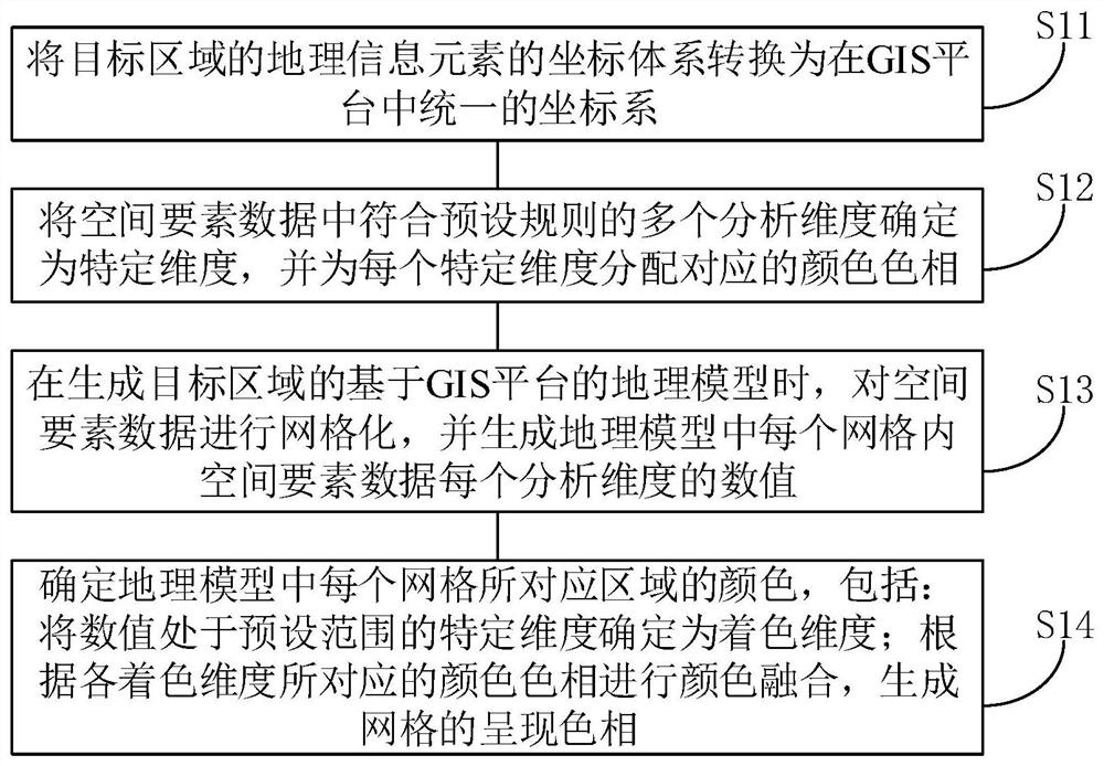
[0041] In order to realize the intuitive presentation of specific data characteristics of spatial feature data in geographic models, such as figure 1 As shown, a GIS-based spatial element data presentation method is provided in an embodiment of the present invention, including steps:
[0042] S11, converting the coordinate system of the geographic information elements of the target area into a unified coordinate system in the GIS platform;
[0043] In order to make the application system based on the GIS platform such as the visualized city management system generated by the geographic model can better visualize the data of various spatial elements, firstly, the geographic information data of each geographic information element in the target area is obtained. Then through the conversion of the coordinate system, the coordinate system of the geographic information elements in the target area is converted into a unified coordinate system in the GIS platform, so that the construc...
Embodiment 3
[0073] In an embodiment of the present invention, a memory is also provided, wherein the memory includes a software program, and the software program is suitable for a processor to execute figure 1 Each step in the corresponding GIS-based spatial feature data presentation method.
[0074] The embodiment of the present invention can be realized by means of software programs, that is, by writing figure 1 Corresponding software program (and instruction set) of each step in the GIS-based spatial element data presentation method, the software program is stored in the storage device, and the storage device is set in the computer device, so that the computer device can be used by the processor The software program is invoked to achieve the purpose of the embodiment of the present invention.
Embodiment 4
[0076] In the embodiment of the present invention, a GIS-based spatial element data presentation device is also provided, the memory included in the GIS-based spatial element data presentation device includes a corresponding computer program product, and the computer program product includes When the program instructions are executed by the computer, the computer can execute the GIS-based spatial element data presentation method described in the above aspects, and achieve the same technical effect.
[0077] image 3 It is a schematic diagram of the hardware structure of a GIS-based spatial element data presentation device as an electronic device in an embodiment of the present invention, such as image 3 As shown, the device includes one or more processors 610 , a bus 630 and memory 620 . Taking a processor 610 as an example, the device may further include: an input device 640 and an output device 650 .
[0078] Processor 610, memory 620, input device 640, and output device ...
PUM
 Abstract
Description
Claims
Application Information
 - R&D
- Intellectual Property
- Life Sciences
- Materials
- Tech Scout
- Unparalleled Data Quality
- Higher Quality Content
- 60% Fewer Hallucinations
Browse by: Latest US Patents, China's latest patents, Technical Efficacy Thesaurus, Application Domain, Technology Topic, Popular Technical Reports.
© 2025 PatSnap. All rights reserved.Legal|Privacy policy|Modern Slavery Act Transparency Statement|Sitemap|About US| Contact US: help@patsnap.com