Method for realizing rapid updating of plane map elements by utilizing close-range remote sensing technology

A technology of plane map and remote sensing technology, which is applied in the direction of database update, photo interpretation, geographic information database, etc., can solve the problems of difficult operation, data redundancy, and heavy workload of internal and external industries, and achieve the purpose of improving the efficiency of mapping and surveying. The effect of simple diagram principle and low professional requirements

Active Publication Date: 2020-09-11
NORTHWEST A & F UNIV
View PDF7 Cites 3 Cited by
  • Summary
  • Abstract
  • Description
  • Claims
  • Application Information

AI Technical Summary

Problems solved by technology

Therefore, although the planar map can be fully updated, the effect is the best, but its update cost is high, the workload is heavy, and the cycle is long. As a more targeted update, the local update method has gradually become the idea adopted in the field of map update.
[0004] The traditional map update technology mainly uses classic surveying and mapping methods such as total station surveying and mapping. Although this "point measurement" surveying and mapping method has high measurement accuracy, the overall mapping efficiency is low and the labor input cost is also high; later, remote sensing The development of technology has brought new means for large-scale mapping. The mapping efficiency of remote sensing technology is high, and the labor cost of the field is basically liberated. However, the current high-resolution satellite remote sensing images are expensive, and the low- and medium-resolution remote sensing images The ability to solve problems is limited, and there are still some problems in practical applications; close-range remote sensing technology represented by unmanned aerial vehicles and ground photogrammetry has gradually become an effective force to supplement satellite remote sensing technology. The accuracy is high, and the manual investment is small, which is a better mapping method; in addition, although the high-tech means represented by 3D lidar can better solve the problem of map surveying and mapping, and the accuracy of mapping High, the visualization effect is good, but there are still technical bottlenecks such as a large amount of data redundancy and point cloud classification at this stage, and it has not been well applied in actual mapping work
[0005] So far, whether it is a comprehensive update or a partial update method, the update method of the planar map has always been inclined to adopt the traditional surveying and mapping technology. Some high-tech information technology is still in the laboratory stage and has not been promoted. Therefore, in the planar There are still great deficiencies and limitations in the actual operation of map updating:
[0006] (1) The traditional surveying and mapping method is still the main method, the overall measurement efficiency is low, and the update cycle is long;
[0007] (2) In order to match with the original map, a large amount of redundant information needs to be measured, there is data redundancy, and the workload of internal and external operations is heavy;
[0008] (3) Existing surveying and mapping methods have high requirements for the professionalism of the operators and are difficult to operate
[0009] Therefore, as far as the current technical means are concerned, there are still many disadvantages in the effect of map update, and it is difficult to meet the needs of rapid urban development for map update efficiency. There is an urgent need for a technology that can achieve fast, efficient, and real-time update of planar maps. means

Method used


Image

  • Method for realizing rapid updating of plane map elements by utilizing close-range remote sensing technology
  • Method for realizing rapid updating of plane map elements by utilizing close-range remote sensing technology
  • Method for realizing rapid updating of plane map elements by utilizing close-range remote sensing technology

Examples


Embodiment Construction

[0027] The present invention will be further described below in conjunction with the accompanying drawings and embodiments.

[0028] The technical method of using close-range remote sensing technology to realize the rapid update of planar map elements has a strong basis in theory and strong feasibility in practical operation. It is a reasonable combination of UAV photogrammetry technology and ground photogrammetry technology. of the mapping method. This technology is not only a powerful supplement to the existing planar map update technology system, but also an improvement and innovation to the existing technology, providing an efficient and convenient idea and technical means for updating planar map elements.

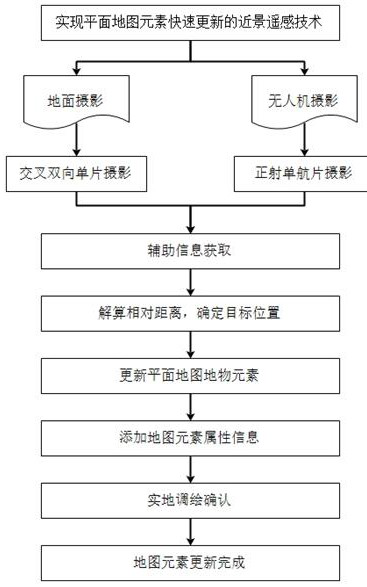
[0029] Such as figure 1 As shown, the present invention provides a method for using close-range remote sensing technology to realize rapid updating of planar map elements, which specifically includes the following steps:

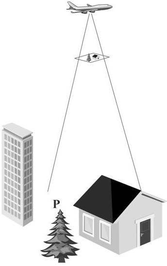
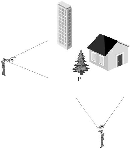
[0030] Step S1, using close-range remote se...


PUM


Abstract

The invention discloses a method for realizing rapid updating of plane map elements by using a close-range remote sensing technology. According to the method, on the basis of original data, local updating of a planimetric map is taken as a target, a close-range remote sensing technology represented by an unmanned aerial vehicle photogrammetry technology and a ground photogrammetry technology is utilized to acquire image information of a target area, at least one obvious feature point is determined, and clear imaging of the feature point in an image is ensured; the relative position relation between the feature points and the target point is calculated through the single image information and the auxiliary feature information, and then the positions of the target point and the target objectare determined; a target object element is updated in a target area on the planar map, and corresponding attribute information is added; and finally, by taking the updated map as a reference, the accuracy of the updated elements is verified in an on-site plotting manner to finish updating the planar map.

Description

technical field [0001] The invention relates to the field of update of planar map elements and supplementary survey and drawing, in particular to a method for realizing rapid update of planar map elements by using close-range remote sensing technology. [0002] technical background [0003] Map update is to correct the elements added, deleted or changed in the real state on the basis of expressing the original state of the shown area, so as to ensure the real-time, accuracy and correctness of the map expression. With the continuous progress of the society and the rapid development of the economy, it is a very important task to update the planar maps, general geographic maps and thematic maps of various scales. As an important part of the map field, planar maps generally have two types of update ideas: comprehensive update and partial update. In terms of technical requirements, large Figure 1 It is generally required to be updated every 10 years or so, and the update cycle o...

Claims


Application Information

Patent Timeline
Patent Type & Authority Applications(China)
IPC IPC(8): G06F16/29G06F16/23G01C11/06
CPCG06F16/29G06F16/23G01C11/06
Inventor 刘金成张青峰张廷龙
Owner NORTHWEST A & F UNIV
Why Eureka
Try Eureka