A Fast Global Positioning Method for Bounded Areas Based on LiDAR

A lidar, bounded area technology, applied in the re-radiation of electromagnetic waves, instruments, navigation, etc., can solve the problems of low positioning accuracy, complex algorithms, and easy to be affected by ambient light, so as to avoid the impact of positioning accuracy, reduce Complexity, the effect of fast global positioning

Active Publication Date: 2021-11-23
SUN YAT SEN UNIV
View PDF10 Cites 0 Cited by
  • Summary
  • Abstract
  • Description
  • Claims
  • Application Information

AI Technical Summary

Problems solved by technology

[0004] In order to overcome the technical defects that the existing global positioning technology is easily affected by ambient light, complex algorithms, and low positioning accuracy in the positioning process, the present invention provides a fast global positioning method for a bounded area of ​​laser radar

Method used


Image

  • A Fast Global Positioning Method for Bounded Areas Based on LiDAR
  • A Fast Global Positioning Method for Bounded Areas Based on LiDAR
  • A Fast Global Positioning Method for Bounded Areas Based on LiDAR

Examples


Embodiment 1

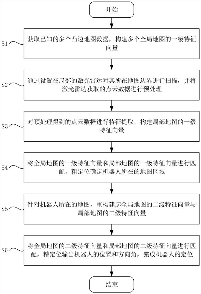
[0054] Such as figure 1 As shown, a fast global positioning method for a lidar bounded area includes the following steps:

[0055] S1: Obtain multiple known convex-edge map data, and construct first-level feature vectors of multiple global maps;

[0056] S2: Scan the boundary of the map with the local lidar, and preprocess the point cloud data obtained by the lidar;

[0057] S3: Perform feature extraction on the preprocessed point cloud data, and construct a first-level feature vector of the local map;

[0058] S4: Match the first-level feature vectors of the global map with the first-level feature vectors of the local map, and roughly locate the map area where the robot is located;

[0059] S5: For the map where the robot is located, reconstruct the secondary feature vector of the global map and the secondary feature vector of the local map;

[0060] S6: Match the secondary eigenvectors of the global map with the secondary eigenvectors of the local map, and output the pos...

Embodiment 2

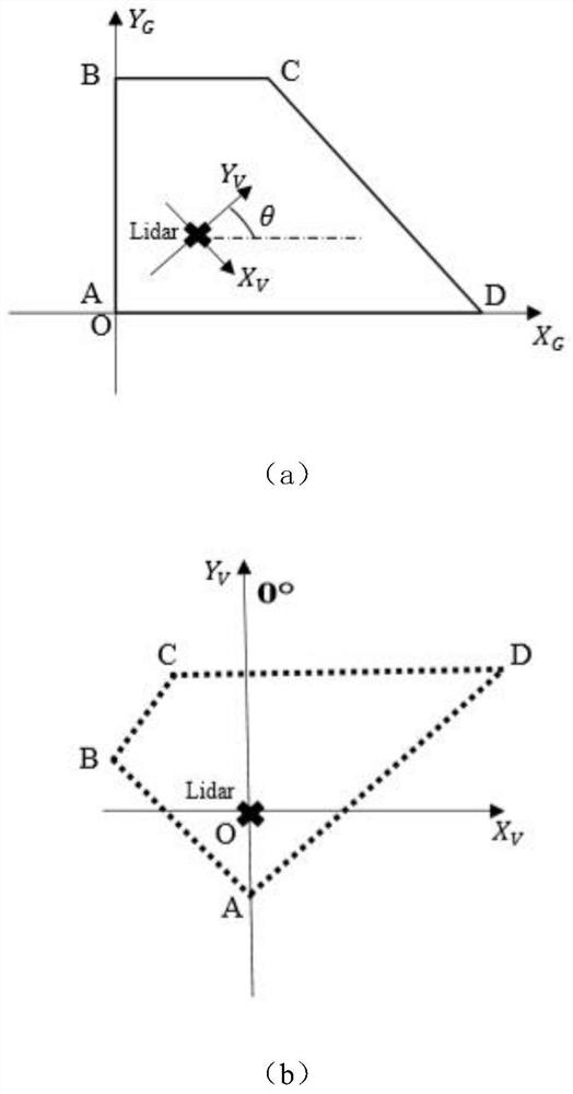
[0063] More specifically, on the basis of Example 1, such as figure 2 As shown, define the conversion relationship between the ground coordinate system and the vehicle coordinate system and the vehicle direction angle as OX G Y G Ground coordinate system, OX V Y V is the vehicle coordinate system. The 0° orientation of the laser radar is defined as the positive direction of the vertical axis of the vehicle coordinate system, and the vehicle direction angle is defined as the angle between the 0° direction of the laser radar and the positive direction of the horizontal axis of the ground coordinate system. The maps in the embodiments are all four-sided convex polygon maps.

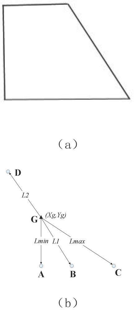
[0064] More specifically, the step S1 is as follows: first perform feature extraction on a plurality of known maps (i.e. global maps) in the ground coordinate system, and substitute the coordinates of k=4 vertices of the convex polygonal map into the barycenter coordinate calculation formula:

[0065] ...


PUM


Abstract

The present invention provides a fast global positioning method for a bounded area of ​​laser radar. By constructing the first-level feature vectors of the global map and the local map and matching them, the rough positioning of the map area where the robot is located is realized; further according to the map where the robot is located , to construct the secondary eigenvectors of the global map and the secondary eigenvectors of the local map, realize the precise positioning of the position and azimuth of the robot, effectively avoid the influence of illumination on the positioning accuracy, use the convex polygonal geometric map as the map representation, and obtain the map-based The lidar positioning algorithm based on eigenvector matching reduces the complexity of the algorithm and realizes the rapid global positioning of the robot in the bounded area.

Description

technical field [0001] The invention relates to the technical field of indoor positioning of mobile robots, and more specifically, to a fast global positioning method in a bounded area of ​​laser radar. Background technique [0002] At present, the field of indoor positioning at home and abroad mainly includes positioning technologies such as radio frequency identification (RFID), Wi-Fi, ZigBee, ultra-wideband (UWB), inertial navigation, ultrasonic, laser, infrared, and Bluetooth. The difference between these positioning technologies lies in the different sensors and data transmission methods, and the core positioning algorithm in the background is the key factor for the positioning effect, including the proximity information method, the multilateral measurement method, the hyperbolic positioning method, and the triangulation positioning method. , fingerprint positioning method and dead reckoning method. As far as the current technological development is concerned, each pos...

Claims


Application Information

Patent Timeline
Patent Type & Authority Patents(China)
IPC IPC(8): G01C21/20G01S17/46G01S17/89
CPCG01C21/206G01S17/46G01S17/89
Inventor 张辉吴海欣林军记文梓豪熊弘俊崔彦
Owner SUN YAT SEN UNIV
Why Eureka
Try Eureka