Soil water content inversion method based on multi-model ensemble learning

A technology of soil water content and integrated learning, which is applied in soil material testing, measuring devices, scientific instruments, etc., can solve problems such as underfitting and overfitting, and achieve improved accuracy and spatial continuity, improved accuracy and interpretability effect

Active Publication Date: 2020-09-18
UNIV OF ELECTRONICS SCI & TECH OF CHINA +2
View PDF9 Cites 13 Cited by
  • Summary
  • Abstract
  • Description
  • Claims
  • Application Information

AI Technical Summary

Problems solved by technology

The machine learning method has strong nonlinear expression ability, is suitable for solving various nonlinear problems, and does not need to consider simplifying the model and ignoring the parameters, and realizes the fusion of multi-source remote sensing data by introducing various parameters. Overfitting and underfitting often occur in high-dimensional data

Method used


Image

  • Soil water content inversion method based on multi-model ensemble learning
  • Soil water content inversion method based on multi-model ensemble learning
  • Soil water content inversion method based on multi-model ensemble learning

Examples


Embodiment

[0045] For the convenience of description, the relevant technical terms appearing in the specific implementation are explained first:

[0046] NDVI (Normalized Difference Vegetation Index): Normalized Difference Vegetation Index

[0047] SASI (Shortwave Angle Slope Index): shortwave angle slope index

[0048] MSAVI (Modified Soil-Adjusted Vegetation Index): Modified soil-adjusted vegetation index

[0049] SIMI (Shortwave Infrared Soil Moisture Index): Shortwave Infrared Soil Moisture Index

[0050] NMDI (Normalized Multi-band Drought Index): normalized multi-band drought index

[0051] DDI (Distance Drought Index): distance drought index

[0052] GVMI (Global Vegetation Moisture Index): Global Vegetation Moisture Index

[0053] EVI (Enhanced Vegetation Index): Enhanced Vegetation Index

[0054] MSI (Moisture Stress Index): Moisture Stress Index

[0055] NDII6 (Normalized Difference Infrared Index 6): the 6th band normalized difference near-infrared index

[0056] NDII7 ...


PUM


Abstract

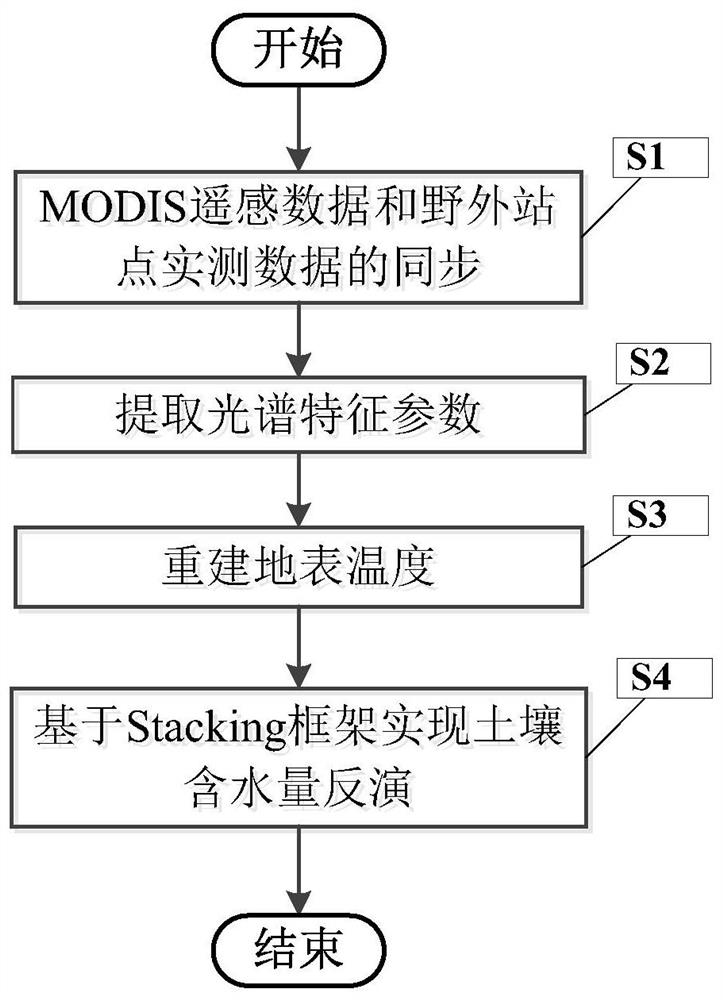
The invention discloses a soil water content inversion method based on multi-model ensemble learning. Firstly, extracting initial input characteristics of a soil water content inversion model by fusing multi-source remote sensing data; then, based on a Stacking framework, training an extreme random tree and an XGBoost model in the framework through the initial input features; obtaining different soil water content prediction values, extracting a temperature-vegetation drought index inversion result, finally building a linear regression model through a fitting tool, and inputting the soil watercontent predicted by an extreme random tree and an XGBoost model and a TVDI inversion result into the linear regression model, thereby outputting a soil water content value.

Description

technical field [0001] The invention belongs to the field of environmental remote sensing technology and machine learning technology, and more specifically relates to a soil water content inversion method based on multi-model integrated learning. Background technique [0002] Soil water content is closely related to the survival of surface organisms. It not only plays an important role in many fields such as agriculture, hydrology, and meteorology, but is even closely related to extreme disasters such as landslides, floods, and fires. Considering the spatial and temporal heterogeneity of soil water content, its precise prediction remains challenging. The soil moisture content can be accurately measured by using TDR soil moisture analyzer or soil weighing method, but such field sampling method is inefficient, expensive in manpower and material resources, and is not suitable for real-time measurement in large areas. Remote sensing technology has the advantages of wide coverag...

Claims


Application Information

Patent Timeline
Patent Type & Authority Applications(China)
IPC IPC(8): G01N21/17G01N21/55G01N33/24G06F30/27G06K9/62
CPCG01N21/17G01N21/55G01N33/246G06F30/27G01N2021/1793G06F18/24323G06F18/214
Inventor 李玉霞程渊李凡何磊李玉珍
Owner UNIV OF ELECTRONICS SCI & TECH OF CHINA
Why Eureka
Try Eureka