
High-precision riverway terrain interpolation method

An interpolation method and high-precision technology, applied in image data processing, 3D modeling, instruments, etc., to save manpower, improve interpolation effect, and improve interpolation accuracy.

Active Publication Date: 2020-09-18
河南省水利勘测设计研究有限公司
View PDF4 Cites 8 Cited by
  • Summary
  • Abstract
  • Description
  • Claims
  • Application Information

AI Technical Summary

Problems solved by technology

[0003] The purpose of the present invention is to provide a high-precision river topography interpolation method, realize the use of river cross-section data combined with satellite remote sensing images that are generally easy to obtain at present, and solve the need to convert river cross-section data into three-dimensional terrain models in two-dimensional hydrodynamic calculations The problem

Method used


Image

  • High-precision riverway terrain interpolation method
  • High-precision riverway terrain interpolation method
  • High-precision riverway terrain interpolation method

Examples


Embodiment Construction

[0023] The embodiments of the present invention will be described in detail below in conjunction with the accompanying drawings. This embodiment is implemented on the premise of the technical solution of the present invention, and detailed implementation methods and specific operating procedures are provided, but the scope of protection of the present invention is not limited to the following Described embodiment.

[0024] The high-precision river topography interpolation method of the present invention comprises the following steps:

[0025] Step 1, first classify the cross-section type of the measured river channel, and determine the number of longitudinal control lines of the measured river channel accordingly;

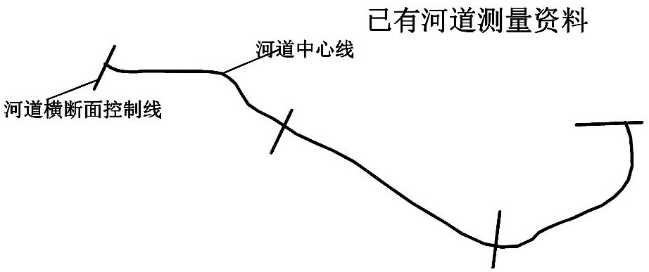
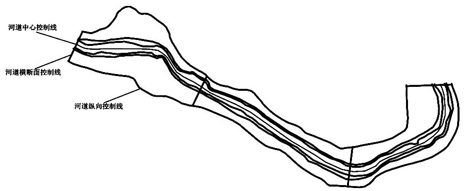
[0026] like figure 1 As shown, there are four cross-section control lines and one channel centerline of the measured river channel in this embodiment; since the cross-section type of the measured river channel is a compound section, seven longitudinal control line...


PUM


Abstract

The invention discloses a high-precision riverway terrain interpolation method, which comprises the following steps of: 1, classifying cross section types of a measured riverway, and determining the number of longitudinal control lines of the measured riverway; 2, superposing a river cross section control line by taking the measured river satellite image as a base map, and drawing a river longitudinal control line; 3, interpolating an elevation value at the intersection point of the cross section line and the longitudinal control line of the river channel according to the elevation data of thecross section of the river channel, and interpolating the longitudinal control line into a three-dimensional curve; 4, converting a riverway cross section control line into a three-dimensional line;and generating basic data of a three-dimensional terrain model together with the interpolated three-dimensional longitudinal control lines, performing triangular mesh subdivision on an interpolation region by adopting a Deluany method, and determining the vertex elevation of a triangular mesh by adopting a two-dimensional linear interpolation method, thereby generating the three-dimensional terrain model. According to the method, the value of the river cross section information is fully mined, and the interpolation precision is improved.

Description

technical field [0001] The invention relates to a river hydrodynamic model used in water conservancy project planning and design, in particular to a high-precision river topography interpolation method. Background technique [0002] With the development of digital simulation technology, river hydrodynamic models are more and more widely used in hydraulic engineering planning and design. When establishing a hydrodynamic model, the collected data must first be generalized to obtain terrain data suitable for river hydrodynamic model calculations. The typical results of river channel topographic survey are the channel cross section and several longitudinal control lines. If a one-dimensional river channel hydrodynamic model is used to calculate the hydraulic elements of the channel, the original measurement results of the channel cross section and central control line can be directly input. However, if a two-dimensional hydrodynamic model is to be used to calculate hydraulic el...

Claims


Application Information

Patent Timeline
IPC IPC(8): G06T17/05
CPCG06T17/05Y02A90/30
Inventor 邢宝龙冯光伟宋文超邰肇悦
Owner 河南省水利勘测设计研究有限公司
Learn More