Method for constructing multi-level three-dimensional terrain model through multi-source data fusion

A 3D terrain, multi-source data technology, applied in 3D modeling, image data processing, structured data retrieval, etc., can solve the problems of low 3D terrain model accuracy, weak construction guidance, single acquisition method, etc. Deployment and solution optimization efficiency, reducing field workload, and good data interaction

Pending Publication Date: 2020-09-29
CHINA RAILWAY ERJU 1ST ENG
View PDF0 Cites 19 Cited by
  • Summary
  • Abstract
  • Description
  • Claims
  • Application Information

AI Technical Summary

Problems solved by technology

[0003] The present invention provides a multi-source data fusion method for constructing a multi-level three-dimensional terrain model to solve the problems of the existing three-dimensional terrain model, such as low precision, single acquisition method, poor expression effect, and weak construction guidance.

Method used


Image

  • Method for constructing multi-level three-dimensional terrain model through multi-source data fusion

Examples


Embodiment

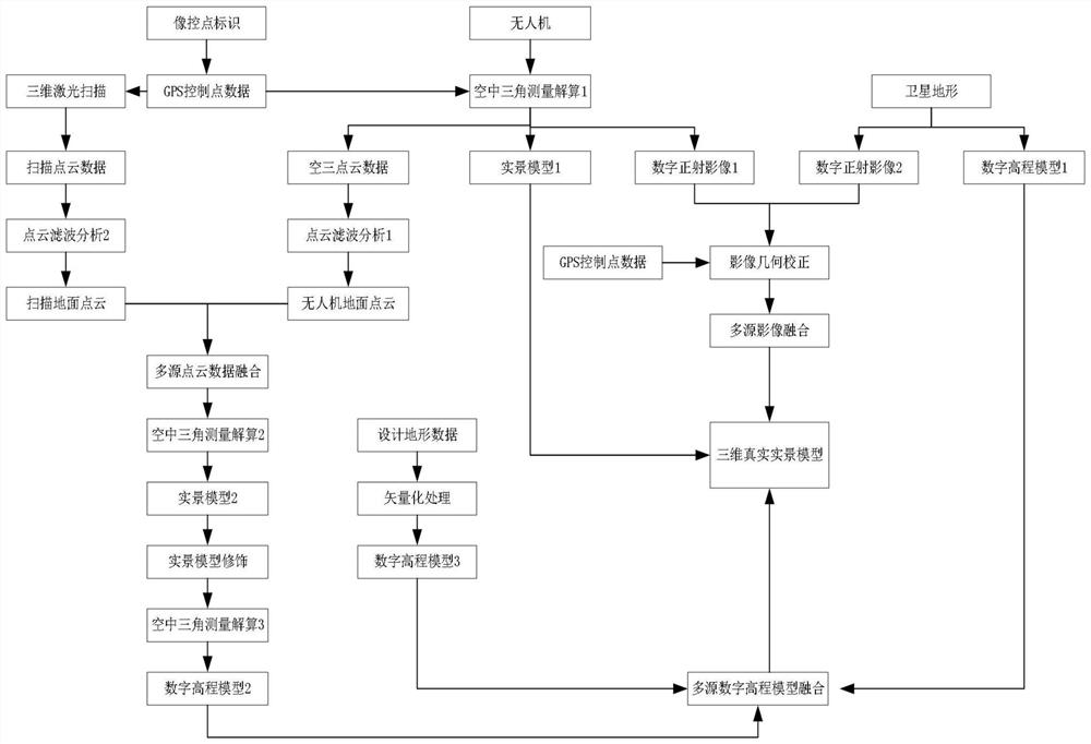
[0048] refer to figure 1 , this embodiment provides a multi-source data fusion method for constructing a multi-level three-dimensional terrain model, the steps are as follows:

[0049] 1) Image control point measurement and design

[0050] 01 Before planning the route, import the KML file of the designed route into GoogleEarth or Aowei satellite map, understand the terrain and landform of the survey area according to the geospatial environment of the route, combine the mileage of the route, and reasonably plan the distribution and personal control of the route The number of flights, the number of flights, the pre-selection of aerial survey take-off points, manual shooting or fully automatic shooting optimize the aerial survey plan to improve operational efficiency.

[0051] 02 The accuracy and quantity of image control points directly affect the accuracy of post-processing of aerial survey data, so the layout and selection of image control points should be as standardized, st...


PUM


Abstract

The invention provides a method for constructing a multi-level three-dimensional terrain model through multi-source data fusion. The method sequentially comprises the steps of image control point measurement and setting, unmanned aerial vehicle flight and data processing, three-dimensional laser scanning data acquisition and processing, terrain design and satellite terrain processing, multi-sourceimage data fusion, multi-source point cloud data fusion and multi-source DEM fusion. Finally, a three-dimensional terrain model is constructed, a single-source DOM + single-source DEM fusion mode, amulti-DOM + single-source DEM fusion mode and a multi-DOM + multi-DEM fusion mode are established, and a multi-level and multi-precision three-dimensional real terrain model is constructed. The problems that an existing three-dimensional terrain model is low in precision, single in obtaining mode, poor in expression effect, poor in construction guidance and the like are solved. The invention belongs to the field of constructional engineering.

Description

technical field [0001] The invention relates to a multi-source data fusion method for constructing a multi-level three-dimensional terrain model, which belongs to the field of construction engineering. Background technique [0002] The 3D real terrain model is composed of digital elevation model (DEM) and digital ortho image (DOM). Among them, the digital elevation model expresses the real terrain undulation characteristics of the ground space, and the digital orthophoto image expresses the ground texture. Subject to the confidentiality requirements of the relevant national departments, high-precision digital elevation models and digital orthophoto data can be purchased at present, and the highest accuracy can reach About 10m, the purchase cost is 30,000 / square kilometer. Although Google Earth, bigmap, Shuijingzhu and other software can obtain satellite images of about 19 levels, the resolution is about 5m, the terrain level is 16, and the highest accuracy can only reach 30...

Claims


Application Information

Patent Timeline
Patent Type & Authority Applications(China)
IPC IPC(8): G06T17/05G06T5/00G06F16/29G01C15/00
CPCG01C15/002G06T5/006G06T17/05G06T2207/10028G06T2207/20221G06F16/29
Inventor 谢显龙胡光全文舟何寿海李忠玉崔宇李国栋龚建伟曹文米才标黄俊峰周磊原菊星周莉郭梅
Owner CHINA RAILWAY ERJU 1ST ENG
Why Eureka
Try Eureka