

Method and system for reconstructing motion trajectory based on mobile platform
A motion trajectory and mobile platform technology, applied in radio wave measurement systems, satellite radio beacon positioning systems, measurement devices, etc., can solve problems such as confusing time sequence, lost stars at location points, and messy motion trajectories, and achieve stable and effective results. , the data is timely, the method is simple and effective
Inactive Publication Date: 2020-10-13
成都同飞科技有限责任公司
View PDF6 Cites 1 Cited by
- Summary
- Abstract
- Description
- Claims
- Application Information
AI Technical Summary
Problems solved by technology
The existing positioning trajectory still has the situation of star loss and drift of position points, and a lot of messy and disordered position point data will be generated on the final trajectory. These data will cause the entire trajectory to be very messy and confuse the time sequence of the entire trajectory process. , moving direction and direction
Method used
View moreImage
Smart ImageViewing Examples

Examples
Embodiment
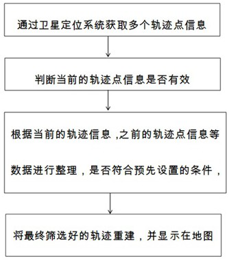
[0051] A kind of method based on mobile platform trajectory reconstruction, comprises the following steps, as figure 1 Shown:
[0052] S1: Obtain the current track point through the satellite positioning system;
[0053] The historical track point is the last valid track point before the current track point is obtained, and the first historical track point is the valid track point by default.
[0054] S2: Judging whether the current track point is valid according to the historical track point:
[0055] If the current track point is valid, construct the motion track based on the historical track point and the current track point, and display the motion track on the map;
Login to View More PUM
 Abstract
The invention discloses a method and a system for reconstructing a motion trajectory based on a mobile platform. The method comprises the following steps of: acquiring a current trajectory point through using a satellite positioning system; judging whether the current trajectory point is valid or not according to historical trajectory points: if the current trajectory point is valid, constructinga motion trajectory according to the historical trajectory points and the current trajectory point, and displaying the motion trajectory on a map; and if the current trajectory point is invalid, abandoning the current trajectory point or taking the current trajectory point as a starting point of another motion trajectory. The invention aims to provide the method and the system for reconstructing the motion trajectory based on the mobile platform, and the method and the system are used for screening and optimizing the acquired trajectory information, filtering useless position information data,sorting the time sequence of the trajectory data, and screening elegant and pulled trajectory points, so that the trajectory of a user is displayed smoothly, regularly, accurately and coherently.
Description
technical field [0001] The present invention relates to the technical field of positioning, in particular to a method and system for reconstructing motion tracks based on a mobile platform. Background technique [0002] The Global Positioning System is a system that uses positioning satellites to perform real-time positioning and navigation around the world. It can provide low-cost, high-precision three-dimensional position, speed and precise timing navigation information for users around the world. At present, satellite positioning technology has been widely used in various fields, such as: measurement, transportation, rescue, agriculture, military industry, etc. [0003] In the field of mobile GIS, water, electricity, gas and other pipe network systems use mobile devices with satellite positioning to locate and locate geographic location information during work. When obtaining location information, it usually adopts a method of multiple consecutive uploads at a certain t...
Claims
Login to View More Application Information
Patent Timeline
 Patent Type & Authority Applications(China)
IPC IPC(8): G01S19/42
CPCG01S19/42
Inventor 穆国庆李儒兵萧阳徐健牟旭阳胡洪祥蒲以富巫若林菅志诚吴鹏飞
Owner 成都同飞科技有限责任公司