Gridding automatic monitoring system integrating augmented reality and geographic information

A geographic information system and augmented reality technology, applied in the field of grid-based automatic monitoring systems, can solve problems such as single function, inability to display, and inability to see the actual situation inside the building, so as to relieve stress, solve visual fatigue, and improve efficiency Effect

Inactive Publication Date: 2020-10-16
塔盾信息技术(上海)有限公司
View PDF7 Cites 8 Cited by
  • Summary
  • Abstract
  • Description
  • Claims
  • Application Information

AI Technical Summary

Problems solved by technology

[0004] In scenarios such as chemical parks and industrial parks, a single GIS electronic map visualization or a single augmented reality technology cannot fully display the different and complex situations in the park, and a single GIS electronic map visualization cannot see the actual situation inside the building , while augmented reality alone cannot achieve geospatial
Ordinary light poles only have functions such as lighting and advertising, and the functions are relatively single.

Method used


Image

  • Gridding automatic monitoring system integrating augmented reality and geographic information
  • Gridding automatic monitoring system integrating augmented reality and geographic information
  • Gridding automatic monitoring system integrating augmented reality and geographic information

Examples


Embodiment Construction

[0039] In order to make the object, technical solution and advantages of the present invention more clearly, the specific implementation of the present invention will be further described below.

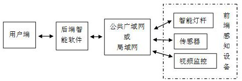
[0040] 1. Front-end sensing equipment mainly includes smart light poles, video surveillance, various sensors and other equipment to collect on-site information.

[0041] 2. Data information transmission in various network situations such as public wide area network or local area network.

[0042] 3. The server side receives the data sent back by the front-end sensing devices (smart light poles, etc.), and provides the service of invoking data to the client software system, and the data refresh frequency can be set according to requirements.

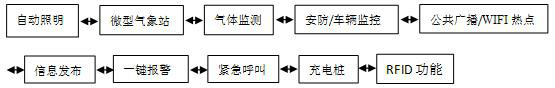
[0043] 4. In this system, functions such as automatic patrol of video surveillance, electronic border, restricted area alarm, automatic early warning, unattended, and data statistical analysis can be set to meet the daily monitoring and manageme...


PUM


Abstract

The invention discloses a gridding automatic monitoring system integrating augmented reality and geographic information. The gridding automatic monitoring system comprises rear-end intelligent software and front-end sensing equipment (an intelligent lamp post and the like). The rear-end intelligent software mainly refers to a gridding automatic monitoring system integrating geographic informationand augmented reality. The front-end sensing equipment (intelligent lamp poles) is installed in different areas of a park and used for video security, miniature meteorological stations, information publishing, broadcasting and the like, the front-end sensing equipment (intelligent lamp poles) sends all data information to the management server, and the management server provides a function of remotely calling data for a user side. The gridding automatic monitoring system integrating geographic information and augmented reality has the functions of multi-parameter fusion early warning, in-parkvehicle monitoring and on-site video transmission. The system can be used remotely through a public wide area network and can also be used through a local area network, and a powerful guarantee is provided for lack of a public network environment in an emergency occasion. The gridding automatic monitoring system integrating geographic information and augmented reality can be applied to industrialparks of petroleum, chemical engineering and the like; according to the functions of automatic patrol, electronic boundary, forbidden zone alarm, unattended operation and the like, potential safety hazards can be rapidly recognized and automatic early warning can be achieved under the unattended operation condition, and powerful information support is provided for safety management and emergency rescue.

Description

technical field [0001] The invention belongs to a gridded automatic monitoring system fused with augmented reality and geographic information. The invention relates to a GIS electronic map visualization and augmented reality fusion gridded automatic monitoring and early warning system, as well as professional database construction and front-end sensing equipment (smart light poles). Background technique [0002] At present, GIS electronic map visualization is based on geospatial database, which collects, manages, operates, simulates, analyzes and displays space-related data, and adopts geographic model analysis method to provide various spatial and dynamic geographic information in a timely manner. Augmented reality technology can mix real content with synthetic content. Specifically, objects in the physical world are converted into two-dimensional images of the virtual world through cameras and other devices, and the graphics seen by human eyes are displayed synchronously ac...

Claims


Application Information

Patent Timeline
Patent Type & Authority Applications(China)
IPC IPC(8): H04N5/222H04N5/232H04N7/18H04N21/44G08B21/24
CPCH04N21/44012H04N5/2224H04N7/18G08B21/24H04N23/60
Inventor 包开阳潘杰
Owner 塔盾信息技术(上海)有限公司
Why Eureka
Try Eureka