Road network generation method and system based on remote sensing image and floating car trajectory

A technology of remote sensing images and floating vehicles, applied in the field of road network analysis, can solve problems such as edge redundancy, inconsistent frequency, and uneven spatial distribution of sampling points.

Active Publication Date: 2020-10-23
广东国地规划科技股份有限公司 +1
View PDF5 Cites 5 Cited by
  • Summary
  • Abstract
  • Description
  • Claims
  • Application Information

AI Technical Summary

Problems solved by technology

These methods have their own advantages and disadvantages. Among them, the clustering algorithm is easy to cause edge redundancy, the kernel density estimation method is easy to smooth out the real road with less data as noise, the trajectory merging algorithm is easy to generate false roads, and GPS itself has sampling points. Due to uneven spatial distribution and inconsistent frequency, it is impossible to obtain a complete road map by relying solely on the trajectory data of the floating car

Method used


Image

  • Road network generation method and system based on remote sensing image and floating car trajectory
  • Road network generation method and system based on remote sensing image and floating car trajectory
  • Road network generation method and system based on remote sensing image and floating car trajectory

Examples


Embodiment Construction

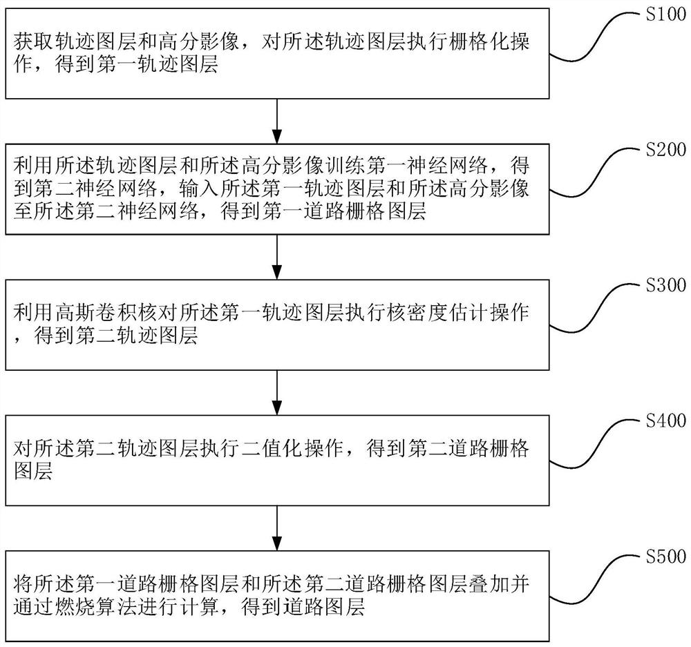
[0053] The idea, specific structure and technical effects of the present invention will be clearly and completely described below in conjunction with the embodiments and accompanying drawings, so as to fully understand the purpose, scheme and effect of the present invention.

[0054]In order to enable those skilled in the art to better understand the solutions of the present invention, the following will clearly and completely describe the technical solutions in the embodiments of the present invention in conjunction with the drawings in the embodiments of the present invention. Obviously, the described embodiments are only It is an embodiment of a part of the present invention, but not all embodiments. Based on the embodiments of the present invention, all other embodiments obtained by persons of ordinary skill in the art without making creative efforts shall fall within the protection scope of the present invention.

[0055] The terms "first", "second", "third" and "fourth" ...


PUM


Abstract

The invention discloses a road network generation method and system based on a remote sensing image and a floating car trajectory. The road network generation method comprises the steps of: acquiringa trajectory layer and a high-resolution image, and carrying out rasterization of the trajectory layer to obtain a first trajectory layer; training a first neural network by using the trajectory layerand the high-resolution image to obtain a second neural network, and acquiring a first road grid layer through using a second neural network; utilizing a Gaussian convolution kernel to execute kerneldensity estimation operation on the first trajectory layer to obtain a second trajectory layer; performing binarization operation on the second trajectory layer to obtain a second road grid layer; and superposing a first road grid layer and the second road grid layer, and performing calculation through using a combustion algorithm to obtain a road layer. According to the road network generation method and the system, the remote sensing image and the floating vehicle trajectory are used as road network data sources, the deep neural networks and a kernel density estimation method are used for processing original data respectively, and then combination processing is performed through adopting a combustion algorithm, so that road network data with higher accuracy and coverage rate is obtained.

Description

technical field [0001] The invention relates to the field of road network analysis, in particular to a road network generation method and system based on remote sensing images and floating vehicle trajectories. Background technique [0002] With the popularization of intelligent transportation and automatic driving technology, it is very important to further improve the accuracy of road network maps. Although the road network data recorded in OpenStreetMap has increased significantly, the total mileage has reached 2.28 million kilometers, and the gap between the road network data and the actual network mileage has also narrowed from 78.4% to 52.2%. However, there are still a large number of road networks that are not reflected in the map There is still a huge workload to improve the current situation of road network maps. [0003] The traditional road network map construction method is mainly through field surveying and high-resolution image vectorization; but both methods ...

Claims


Application Information

Patent Timeline
Patent Type & Authority Applications(China)
IPC IPC(8): G01C21/32G06N3/08G06N3/04
CPCG01C21/32G06N3/08G06N3/045
Inventor 刘禹麒庄浩铭张鸿辉周裕丰梁伟峰李建平
Owner 广东国地规划科技股份有限公司
Why Eureka
Try Eureka