Three-dimensional building fine geometric reconstruction method integrating airborne and vehicle-mounted three-dimensional laser point clouds and streetscape images

A 3D laser and building technology, used in 3D modeling, mechanical equipment, combustion engines, etc., can solve the problems of density, occlusion, classifier performance, and few attempts to classify outdoor point clouds.

Pending Publication Date: 2020-10-23
山东水利技师学院
View PDF0 Cites 55 Cited by
  • Summary
  • Abstract
  • Description
  • Claims
  • Application Information

AI Technical Summary

Problems solved by technology

Therefore, this method cannot be applied to semantic segmentation of large outdoor scenes
[0015] In general, the traditional point cloud semantic segmentation research relies on artificial features, and is greatly affected by density, occlusion, and classifier performance.
However, the gradually emerging deep learning framework has made good progress in indoor point cloud semantic segmentation, but there are few attempts in outdoor point cloud classification.
These emerging point cloud segmentation networks usually have shortcomings such as excessive calculation and loss of large-scale information.
In addition, few studies have been able to jointly process 3D point clouds and street view images, but with the rapid accumulation of multi-source data, it is necessary to propose a semantic segmentation framework for joint multi-source data

Method used


Image

  • Three-dimensional building fine geometric reconstruction method integrating airborne and vehicle-mounted three-dimensional laser point clouds and streetscape images
  • Three-dimensional building fine geometric reconstruction method integrating airborne and vehicle-mounted three-dimensional laser point clouds and streetscape images
  • Three-dimensional building fine geometric reconstruction method integrating airborne and vehicle-mounted three-dimensional laser point clouds and streetscape images

Examples


Embodiment Construction

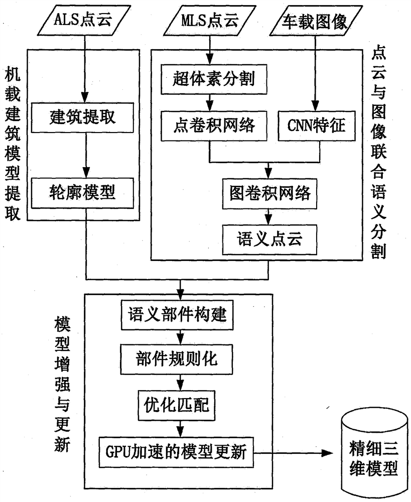
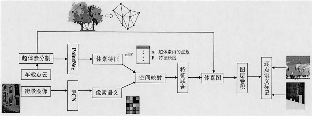
[0031] The overall research train of thought of the present invention is as figure 1 As shown, it contains three modules: airborne building model extraction, point cloud and image joint semantic segmentation, model enhancement and update. The basic input data of this research is the airborne lidar point cloud, the vehicle lidar point cloud and the corresponding vehicle image or matching street view image. In the on-board building model extraction module, the buildings in the point cloud will be identified first and used to build a rough building outline model. In the semantic segmentation module, the geometric information contained in the vehicle point cloud will be fused with the color texture and topological information contained in the image, so as to improve the semantic segmentation accuracy of the point cloud. Based on this, the task of the third module is to integrate the architecturally relevant semantic point cloud and the rough outline model produced onboard to incr...


PUM


Abstract

The invention provides a three-dimensional building fine geometric reconstruction method integrating airborne and vehicle-mounted three-dimensional laser point clouds and streetscape images. The method comprises the following steps: (1) a quick modeling method based on airborne laser data; (2) combining the semantic segmentation framework of the vehicle-mounted point cloud and the image; and (3) amodel automatic enhancement algorithm fusing multi-source data. According to the method, airborne laser point cloud, vehicle-mounted laser point cloud and streetscape images are taken as research objects, model reconstruction, model enhancement and updating are taken as targets, joint processing of point cloud and image data of different platforms is realized, and the fusion potential of variousdata is fully mined. The final research result will perfect the fusion and fine modeling framework of vehicle-mounted-airborne data, promote the development of the point cloud data semantic segmentation technology, and serve the emerging application fields of unmanned driving and the like.

Description

technical field [0001] The invention relates to a method for fine geometric reconstruction of three-dimensional buildings that integrates airborne and vehicle-mounted three-dimensional laser point clouds and street view images, and belongs to the field of laser radar and street view image remote sensing data processing technology. Background technique [0002] The 3D model of the city is an important basis for basic surveying and mapping, intelligent transportation, urban management and spatial analysis. In recent years, with the development of autonomous driving and autonomous logistics, higher requirements have been placed on the accuracy and fineness of 3D models. For example, in driverless driving, detailed 3D models can assist vehicles in navigating and docking. In past studies, airborne lidar and vehicle-mounted lidar are important data sources for reconstructing 3D models of cities. Airborne lidar data is collected in the air, which contains rich roof information, b...

Claims


Application Information

Patent Timeline
Patent Type & Authority Applications(China)
IPC IPC(8): G06T17/20
CPCG06T17/20Y02T10/40
Inventor 马艳艳孙卫锋
Owner 山东水利技师学院
Why Eureka
Try Eureka