GPS unmanned aerial vehicle control method

A control method and unmanned aerial vehicle technology, applied in non-electric variable control, control/regulation system, three-dimensional position/channel control, etc., can solve problems such as communication constraints of unmanned aerial vehicle formation system

Inactive Publication Date: 2020-10-30
广州狸园科技有限公司
View PDF0 Cites 4 Cited by
  • Summary
  • Abstract
  • Description
  • Claims
  • Application Information

AI Technical Summary

Problems solved by technology

[0004] The object of the present invention is to provide a GPS unmanned aerial vehicle control method

Method used


Image

  • GPS unmanned aerial vehicle control method
  • GPS unmanned aerial vehicle control method
  • GPS unmanned aerial vehicle control method

Examples


Embodiment Construction

[0066] The present invention will be further described below in conjunction with the accompanying drawings.

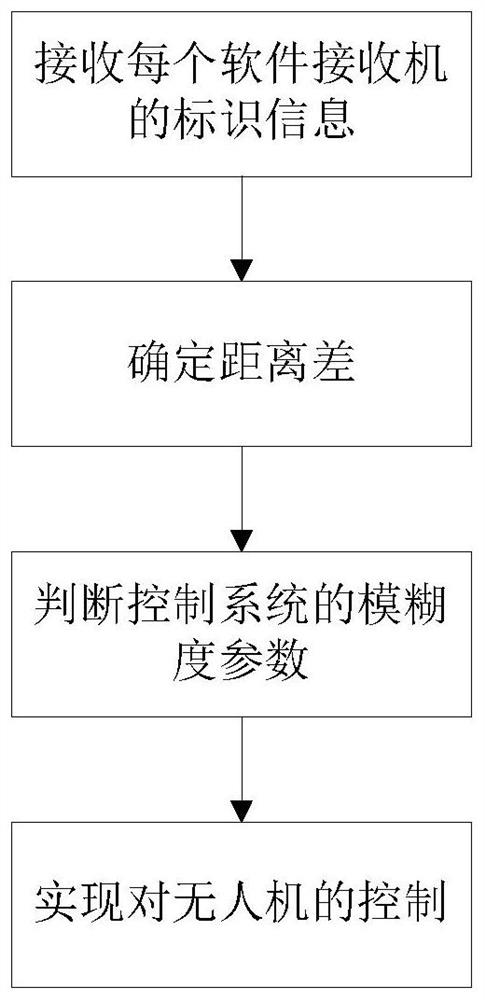
[0067] A GPS unmanned aerial vehicle control method, comprises the steps:

[0068] (1) The control system receives the identification information of each software receiver, and receives the time when each software receiver sends the control signal to the UAV controller;

[0069] (2) calculate any two software receivers and receive the estimated value of the clock of the control signal, collect the electromagnetic wave propagation speed and determine the distance difference between the UAV controller and the corresponding two software receivers;

[0070] (3) Judging the ambiguity parameters of the control system with the momentum information of any two software receivers;

[0071] (4) Taking the ambiguity parameter as input and taking the position information of the UAV controller as output, the convolutional neural network is trained to obtain the position information...


PUM


Abstract

The invention belongs to the technical field of unmanned aerial vehicle control, and particularly relates to a GPS unmanned aerial vehicle control method. The method comprises the following steps that(1) a control system receives identification information of each software receiver, and receives time when each software receiver sends a control signal to an unmanned aerial vehicle controller; and(2) clock estimation values of the control signals received by any two software receivers is calculated, and the distance difference between the unmanned aerial vehicle controller and the two corresponding software receivers is determined according to the clock estimation values of the ultra-bandwidth nonlinearity and the electromagnetic wave propagation speed. According to the technical scheme ofthe invention, the identification information of each software receiver is received, the time when each software receiver sends the control signal to the unmanned aerial vehicle controller is received, and the distance difference between the unmanned aerial vehicle controller and the software receivers is determined according to the time difference and the electromagnetic wave propagation speed,thereby finally determining the position information of the unmanned aerial vehicle controller, and achieving the positioning of the unmanned aerial vehicle controller.

Description

technical field [0001] The invention belongs to the technical field of drone control, and in particular relates to a GPS drone control method. Background technique [0002] In recent years, with the vigorous development of drone technology, countries, both official and private, have invested a lot of energy and financial resources. Similar to most high-tech technologies, the initial research on drones was vigorously carried out by the military, and modern military warfare is inseparable from the application of drones. Whether drones participate in battlefield logistics, such as terrain mapping, battle situation detection, or even direct participation in battle, etc., they all play a huge role. Today, drones have gradually entered every household, and have become a typical case of military-to-civilian use. However, in the traditional mode, the prescribed tasks completed by a single UAV are often relatively simple, and the error tolerance rate is very low. Scientists have o...

Claims


Application Information

Patent Timeline
IPC IPC(8): G05D1/10G01S19/43G01S19/47
CPCG01S19/43G01S19/47G05D1/104
Inventor 谭梅
Owner 广州狸园科技有限公司
Why Eureka
Try Eureka