
Vehicle-mounted laser radar scanning target arrangement and measurement method

A vehicle-mounted laser radar and measurement method technology, which is applied in the field of vehicle-mounted laser radar scanning target layout and measurement, can solve the problems of large auxiliary measurement workload for target layout, high operating costs, lack of specifications and measurement methods, etc., and improve surveying and mapping production capacity , the effect of improving reliability

Inactive Publication Date: 2020-11-06
山东鲁邦地理信息工程有限公司
View PDF3 Cites 5 Cited by
  • Summary
  • Abstract
  • Description
  • Claims
  • Application Information

AI Technical Summary

Problems solved by technology

[0003] 1. The auxiliary measurement workload of target layout is heavy, and the risk of operation safety is high: Correcting point cloud data through target control points is an essential process for vehicle radar scanning, but the target point layout density, specifications and measurement methods lack the guidance and operation basis of relevant norms and standards , in theory, the denser the target points, the higher the accuracy and reliability of the point cloud data, but the higher the workload of auxiliary measurement, the higher the construction risk of the road surface operation, and the higher the operating cost, how to determine the target layout with the best cost performance Significant to the measurement scheme

Method used


Image

  • Vehicle-mounted laser radar scanning target arrangement and measurement method
  • Vehicle-mounted laser radar scanning target arrangement and measurement method
  • Vehicle-mounted laser radar scanning target arrangement and measurement method

Examples


Embodiment Construction

[0036] Below in conjunction with embodiment the present invention is further described in detail.

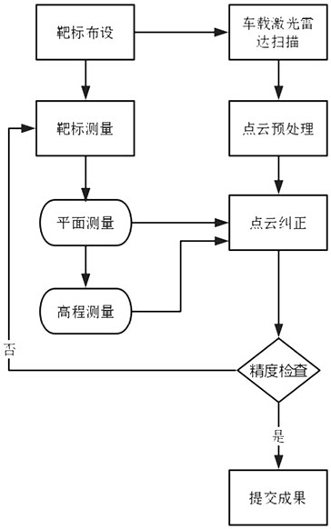
[0037] Such as Figure 1 to Figure 4 As shown, a vehicle-mounted lidar scanning target layout and measurement method includes the following steps:

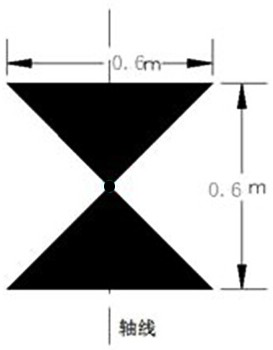
[0038] (1) Determination of target shape and specification: 60cm*60cm square, in the shape of a triangle with upper and lower vertices facing each other and connected; figure 2 shown.

[0039] (2) Mark layout:

[0040] A. Material selection: use road marking paint, the color can be white or red, mainly in eye-catching colors, and it is laid by making molds and artificially evenly brushing;

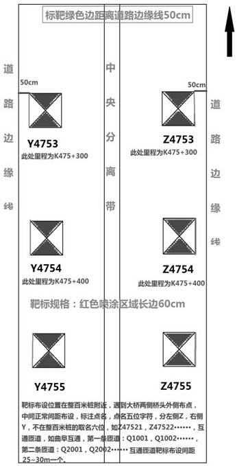
[0041] B. Marking setting: It should be arranged on the flat road surface in the emergency lanes on both sides of the expressway, avoiding low-lying areas, protrusions, ruts, and roads with large slopes or sudden changes, and the axis of the marking is parallel to the sideline of the road; when encountering bridges and culverts When using br...


PUM


Abstract

The invention discloses a vehicle-mounted laser radar scanning target arrangement and measurement method. The method comprises the following steps of (1) determining the shape and specification of a target, (2) laying a survey mark, (3) target control point measurement, (4) target plane control measurement, and (5) target elevation control measurement. Compared with the prior art, the method has the advantages that (1) the target laying density is reduced by 30%, and the working efficiency is improved by 40%; (2) the problem of inconsistent uplink and downlink separated scanning precision is solved, and the reliability of the point cloud data is improved; and (3) new technology and new process research is carried out, a high-speed and efficient surveying and mapping production system is constructed, the highway reconstruction and extension surveying and mapping production capacity is effectively improved, and the ultrahigh precision requirements that the error in the pavement point cloud plane position is superior to + / -3 cm, and the error in the elevation is superior to + / -2 cm are met.

Description

technical field [0001] The invention relates to a measurement method, in particular to a vehicle-mounted laser radar scanning target layout and measurement method. Background technique [0002] The use of vehicle-mounted mobile measurement technology can obtain close-range ultra-high-precision and ultra-high-density point cloud data, especially in the field of highway reconstruction and expansion. Its advantages are obvious, such as fast scanning speed and high safety. But still there are following deficiencies: [0003] 1. The workload of auxiliary measurement for target layout is heavy, and the risk of operation safety is high: correcting point cloud data through target control points is an essential process for vehicle radar scanning, but the density, specifications and measurement methods of target points lack the guidance and operation basis of relevant norms and standards , in theory, the denser the target points, the higher the accuracy and reliability of the point c...

Claims


Application Information

Patent Timeline
IPC IPC(8): G01S7/497
CPCG01S7/4972
Inventor 沈彪群朱俊利刘世从周平高波
Owner 山东鲁邦地理信息工程有限公司
Learn More