Digital elevation model-oriented arbitrary section catchment area boundary and river network extraction method

A technology of digital elevation model and extraction method, which is applied in the fields of hydrology, water resources, and geographic information system, can solve the problems of strict data requirements and error-prone, and achieve the effect of simple code structure and convenient operation.

Pending Publication Date: 2020-12-01
SUN YAT SEN UNIV
View PDF0 Cites 2 Cited by
  • Summary
  • Abstract
  • Description
  • Claims
  • Application Information

AI Technical Summary

Problems solved by technology

[0003] In order to solve the existing DEM-based water system extraction algorithm that needs to accurately divide the watershed boundary and the river network water system upstream of the specified section, there

Method used


Image

  • Digital elevation model-oriented arbitrary section catchment area boundary and river network extraction method
  • Digital elevation model-oriented arbitrary section catchment area boundary and river network extraction method
  • Digital elevation model-oriented arbitrary section catchment area boundary and river network extraction method

Examples


Embodiment 1

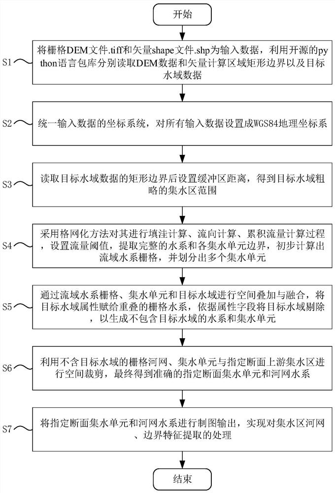
[0049] Such as figure 1 As shown in the figure, the method of extracting boundary and river network of arbitrary cross-section watershed oriented to digital elevation model includes the following steps:

[0050] S1: Take the raster DEM file .tiff and the vector shape file .shp as input data, and use the open source python language package library to read the DEM data and vector calculation area rectangle boundary and target water data respectively;

[0051] S2: Unify the coordinate system of the input data, and set all the input data to the WGS84 geographic coordinate system to avoid the problem of inconsistency in subsequent spatial calculation boundaries due to inconsistent coordinate systems;

[0052] S3: In order to narrow the calculation range of section extraction in unknown target waters, set the rectangular boundary buffer (. the extent of the water area;

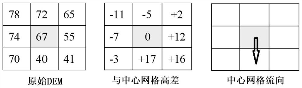
[0053] S4: Use the grid method to perform filling calculation, flow direction calculation, and cumulative flow ca...

Embodiment 2

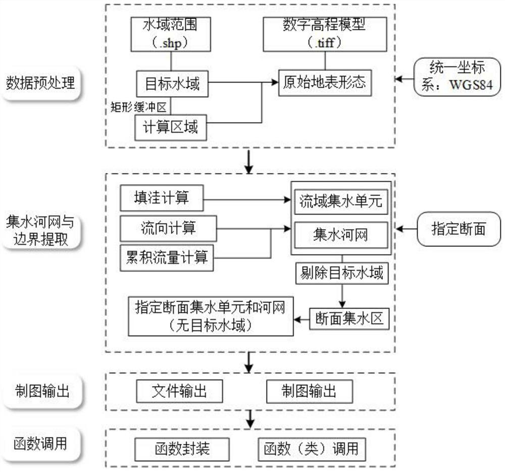
[0077] More specifically, on the basis of Example 1, in order to compare the applicability of a digital elevation model-oriented method for extracting watershed river networks and boundaries programmatically in the specified target water section, this implementation case uses Python 3 as a platform, The extraction of river network and catchment boundary of three typical reservoir sections is taken as an example to verify whether the method is accurate in the extraction results in the reservoir watershed. Such as image 3 As shown in , the steps include: preprocessing, watershed river network and boundary extraction, map output, and function call.

[0078] S1. Preprocessing: its steps include file reading and projection conversion, merging and cropping, mask extraction. Use gpd.read_file() to read the water range of shp files in batches, and then use GeoDataFrame.crs() to assign WGS84 coordinate system ('epsg:4326') to files without spatial reference, and use GeoDataFrame.to ...


PUM


Abstract

The invention provides an arbitrary section catchment area boundary and river network extraction method for a digital elevation model. A flow direction partship relationship between a space grid unitwhere a section is located and other grid units is considered; dividing section upstream and space grid boundaries, extracting a catchment area river network system by taking the section upstream andspace grid boundaries as boundaries on the basis of eliminating a target water area coverage area, flexibly extracting a catchment boundary and a river network at the section upstream according to target water area sections of a river, a lake and a reservoir which are considered to be set, and defining a section hydrological influence orientation; meanwhile, by means of the development environmentof Python3 language, the code structure is simple, operation is convenient, and the method is an effective method for automatically extracting the river network water system of the pointed section catchment area and dividing the catchment units.

Description

technical field [0001] The invention relates to the fields of hydrology and water resources and geographic information systems, and more specifically, relates to a digital elevation model-oriented method for extracting boundaries and river networks of arbitrary cross-section catchment areas. Background technique [0002] Digital elevation model (Digital Elevation Model), referred to as DEM, is to realize the digital simulation of ground terrain (that is, the digital expression of terrain surface form) through limited terrain elevation data. The surface water system extracted based on DEM is the main input of most hydrological models, and it is also the basic support for the development and utilization of water resources in the basin, disaster prevention and mitigation, and ecological environment protection. In the actual application process, the extraction of watershed boundary and water system is realized according to the flow direction and flow affiliation respectively. Ac...

Claims


Application Information

Patent Timeline
IPC IPC(8): G06T17/05G06T17/20
CPCG06T17/05G06T17/205
Inventor 赵铜铁钢杨振华
Owner SUN YAT SEN UNIV
Why Eureka
Try Eureka