River and lake water quality monitoring method based on high-resolution satellite images

A satellite image and water quality monitoring technology, which is applied to image detector methods, image signal processing, measurement devices, analysis materials, etc., can solve the problems of small number of monitoring points, high cost, difficult to control costs, etc., and achieve a wide range of monitoring , fast effect

Inactive Publication Date: 2020-12-08
山东锋士信息技术有限公司
View PDF5 Cites 29 Cited by
  • Summary
  • Abstract
  • Description
  • Claims
  • Application Information

AI Technical Summary

Problems solved by technology

[0008] Aiming at the deficiencies of the prior art, the present invention provides a river and lake water quality monitoring method based on high-resolution satellite images, which solves the problem that there are too many uncontrolled factors in the entire monitoring process, resulting in the inability to guarantee the accuracy and authenticity of the monitoring results. Monitoring limited water quality stati

Method used


Image

  • River and lake water quality monitoring method based on high-resolution satellite images
  • River and lake water quality monitoring method based on high-resolution satellite images
  • River and lake water quality monitoring method based on high-resolution satellite images

Examples


Embodiment 1

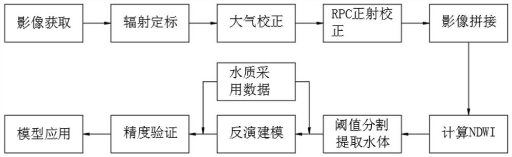
[0039] A method for monitoring river and lake water quality based on high-resolution satellite images, comprising the following steps:

[0040] S1. Radiometric calibration of satellite images: use the remote sensor to observe the electromagnetic energy radiated or reflected by the target object, the measured value obtained from the remote sensor and the physical quantity such as the spectral reflectance or spectral radiance of the target object, to eliminate the distortion of the spectral brightness, according to the radiation Calibration formula: L b = gain b ×DN b +offset b , to calculate the radiance value;

[0041] S2. Atmospheric correction: Using the code of the MODTRAN radiation transfer model, according to the pixel-level correction, the sensor parameters, data acquisition time, atmospheric model, aerosol model, water vapor content, initial visibility, and spectral response function are given, and the real surface is calculated. reflectivity data;

[0042] S3. RPC o...

Embodiment 2

[0063] A method for monitoring river and lake water quality based on high-resolution satellite images, comprising the following steps:

[0064] S1. Radiometric calibration of satellite images: use the remote sensor to observe the electromagnetic energy radiated or reflected by the target object, the measured value obtained from the remote sensor and the physical quantity such as the spectral reflectance or spectral radiance of the target object, to eliminate the distortion of the spectral brightness, according to the radiation Calibration formula: L b = gain b ×DN b +offset b , to calculate the radiance value;

[0065] S2. Atmospheric correction: Using the code of the MODTRAN radiation transfer model, according to the pixel-level correction, the sensor parameters, data acquisition time, atmospheric model, aerosol model, water vapor content, initial visibility, and spectral response function are given, and the real surface is calculated. reflectivity data;

[0066] S3. RPC...

Embodiment 3

[0087] A method for monitoring river and lake water quality based on high-resolution satellite images, comprising the following steps:

[0088] S1. Radiometric calibration of satellite images: use the remote sensor to observe the electromagnetic energy radiated or reflected by the target object, the measured value obtained from the remote sensor and the physical quantity such as the spectral reflectance or spectral radiance of the target object, to eliminate the distortion of the spectral brightness, according to the radiation Calibration formula: L b = gain b ×DN b +offset b , to calculate the radiance value;

[0089] S2. Atmospheric correction: Using the code of the MODTRAN radiation transfer model, according to the pixel-level correction, the sensor parameters, data acquisition time, atmospheric model, aerosol model, water vapor content, initial visibility, and spectral response function are given, and the real surface is calculated. reflectivity data;

[0090] S3. RPC...


PUM


Abstract

The invention discloses a river and lake water quality monitoring method based on high-resolution satellite images. The river and lake water quality monitoring method comprises satellite image radiometric calibration, atmospheric correction, RPC orthographic correction, image splicing, automatic water body extraction, water quality quantitative inversion modeling, water quality quantitative inversion model precision verification and water quality quantitative inversion model application. The invention relates to the technical field of inland water environment remote sensing science, in particular to a river and lake water quality monitoring method based on a high-resolution satellite image, which has the advantages of wide monitoring range, high speed, low cost and convenience in long-termdynamic monitoring by utilizing a remote sensing technology. A multiple linear regression model between different water quality parameter concentrations and image waveband reflectivity is establishedby combining sampling data of a water quality monitoring station and representation of various substances in a water body on a remote sensing image, and a relative error and an absolute error of themodel are calculated according to an inversion result, so as to promote the model, and water quality evaluation of the whole river and even a water area with a larger range is achieved.

Description

technical field [0001] The invention relates to the field of inland water environment remote sensing science and technology, in particular to a river and lake water quality monitoring method based on high-resolution satellite images. Background technique [0002] River and lake water quality monitoring is one of the main contents of environmental monitoring. It is an accurate, timely and comprehensive reflection of the current development trend of water quality, providing scientific basis for water environment management, pollution source control, environmental planning, etc. It also plays a vital role in maintaining the ecological health of rivers and lakes. At present, the methods of river and lake water quality monitoring mainly rely on traditional physical and chemical monitoring, that is, to determine monitoring sites or outlets, arrange sampling time, sampling frequency and sampling parameters, conduct regular sampling, and conduct indoor physical and chemical analysis...

Claims


Application Information

Patent Timeline
IPC IPC(8): G01N21/25G01N21/47G01N21/17
CPCG01N21/17G01N21/25G01N21/4738G01N2021/1765G01N2021/1797
Inventor 孙启玉郭伟李红超
Owner 山东锋士信息技术有限公司
Why Eureka
Try Eureka