A map generation method, device and system based on imu and lidar

A lidar and map generation technology, applied in the direction of measuring devices, radio wave measurement systems, satellite radio beacon positioning systems, etc., can solve the problems of slow matching algorithm between frames, complex point cloud map drawing process, etc., to speed up calculation Speed, meet the needs of high-precision map construction, fast effect

Active Publication Date: 2022-06-21
武汉威图传视科技有限公司
View PDF8 Cites 0 Cited by
  • Summary
  • Abstract
  • Description
  • Claims
  • Application Information

AI Technical Summary

Problems solved by technology

[0003] The purpose of the present invention is to overcome the above technical deficiencies, provide a map generation method, device, system and computer storage medium based on IMU and laser radar, and solve the problem of complex point cloud map drawing process and slow frame matching algorithm in the prior art technical problem

Method used


Image

  • A map generation method, device and system based on imu and lidar
  • A map generation method, device and system based on imu and lidar
  • A map generation method, device and system based on imu and lidar

Examples


Embodiment 1

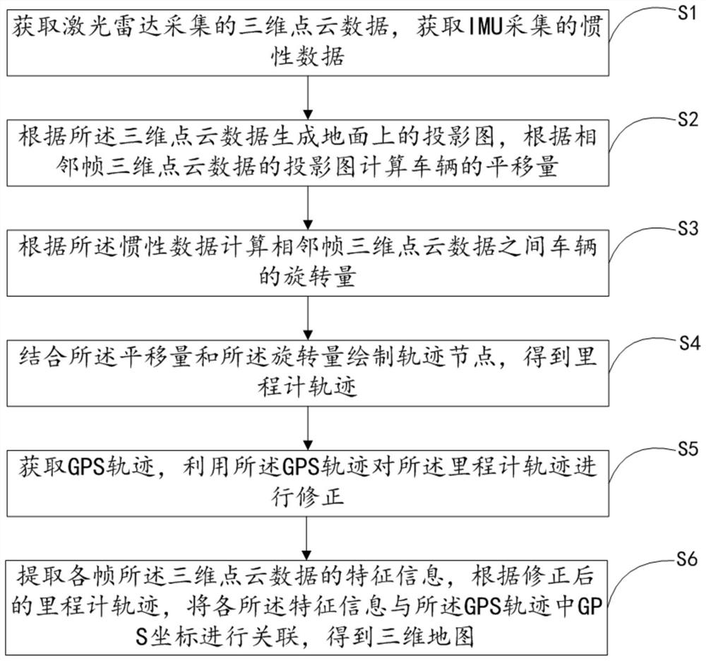
[0027] like figure 1 As shown, Embodiment 1 of the present invention provides a map generation method based on IMU and lidar, including the following steps:

[0028] S1. Obtain 3D point cloud data collected by lidar, and obtain inertial data collected by IMU;

[0029] S2, generating a projection map on the ground according to the three-dimensional point cloud data, and calculating the translation amount of the vehicle according to the projection map of the three-dimensional point cloud data of adjacent frames;

[0030] S3, calculating the rotation amount of the vehicle between the three-dimensional point cloud data of adjacent frames according to the inertial data;

[0031] S4, drawing a trajectory node in combination with the translation amount and the rotation amount to obtain an odometer trajectory;

[0032] S5, acquiring a GPS track, and using the GPS track to correct the odometer track;

[0033] S6. Extract feature information of the three-dimensional point cloud data ...

Embodiment 2

[0146] Embodiment 2 of the present invention provides a map generation device based on IMU and lidar, including a processor and a memory, where a computer program is stored in the memory, and when the computer program is executed by the processor, the implementation provided in Embodiment 1 is realized A method for map generation based on IMU and lidar.

[0147] The map generation device based on IMU and lidar provided by the embodiment of the present invention is used to realize the map generation method based on IMU and lidar. Therefore, the technical effect of the map generation method based on IMU and lidar is based on IMU and laser The radar map generation device is also equipped, and will not be repeated here.

Embodiment 3

[0149] like Figure 4 As shown, Embodiment 3 of the present invention provides a map generation system based on IMU and lidar, including the map generation device based on IMU3 and lidar provided in Embodiment 2, and also includes vehicle body 1, lidar 2, IMU3 and GPS receiver 4;

[0150] The map generation device based on IMU and lidar, lidar 2, IMU3 and GPS receiver 4 are all installed on the vehicle body 1, and the lidar 2, IMU3 and GPS receiver 4 are respectively connected with the IMU-based receiver 4. It is electrically connected to the map generating device of the lidar;

[0151] The lidar 2 is used to collect 3D point cloud data, and send the 3D point cloud data to the map generation device based on IMU and lidar;

[0152] The IMU3 is used to collect inertial data of the vehicle, and send the inertial data to the map generation device based on the IMU and lidar;

[0153] The GPS receiver 4 is connected to a remote differential GPS reference station 6, and is used to...


PUM


Abstract

The invention relates to the technical field of map construction based on computer vision, and discloses a map generation method based on IMU and laser radar, comprising the following steps: obtaining three-dimensional point cloud data collected by laser radar, and obtaining inertial data collected by IMU; according to the The three-dimensional point cloud data generates a projection map on the ground, and calculates the translation amount of the vehicle according to the projection map of the adjacent frame three-dimensional point cloud data; calculates the rotation amount of the vehicle between the adjacent frame three-dimensional point cloud data according to the inertial data; The translation amount and the rotation amount are used to draw the trajectory node to obtain the odometer trajectory; obtain the GPS trajectory, and use the GPS trajectory to correct the odometer trajectory; extract the feature information of the three-dimensional point cloud data in each frame, and then modify After the odometer track, each feature information is associated with the GPS coordinates in the GPS track to obtain a three-dimensional map. The invention has the technical effects of high map precision, fast map building speed and small memory occupation.

Description

technical field [0001] The invention relates to the technical field of map construction based on computer vision, in particular to a map generation method, device, system and computer storage medium based on IMU and lidar. Background technique [0002] High-precision maps are the basis for automatic driving positioning. Traditional maps combined with GPS positioning are easy to operate, but the positioning accuracy can only reach about 10m. In addition, point cloud maps constructed based on laser point cloud matching are commonly used, but due to the matching between frames It is slow and takes up a lot of memory, which makes the drawing process complicated. SUMMARY OF THE INVENTION [0003] The purpose of the present invention is to overcome the above-mentioned technical deficiencies, provide a map generation method, device, system and computer storage medium based on IMU and lidar, and solve the problems of complex point cloud map mapping process and slow inter-frame mat...

Claims


Application Information

Patent Timeline
Patent Type & Authority Patents(China)
IPC IPC(8): G01C21/16G01S17/86G01S19/47G01S19/45
CPCG01C21/165G01S17/86G01S19/47G01S19/45
Inventor 胡钊政朱云涛陶倩文李飞彭超
Owner 武汉威图传视科技有限公司
Why Eureka
Try Eureka