GPS delay time self-adaptive extended Kalman filtering navigation algorithm

A technology of extending Kalman and delay time, applied in the field of adaptive integrated navigation algorithm, can solve problems such as aligning GPS, and achieve the effect of improving navigation accuracy

Active Publication Date: 2020-12-18
QINGDAO TECHN COLLEGE
View PDF5 Cites 0 Cited by
  • Summary
  • Abstract
  • Description
  • Claims
  • Application Information

AI Technical Summary

Problems solved by technology

However, since the data delay time measured by GPS is not a fixed value, it is difficult to align the measured value of GPS with the measured value of MEMS sensor in historical time. Therefore, it is necessary to improve the traditional integrated navigation algorithm to further improve the navigation parameters. The solution accuracy

Method used


Image

  • GPS delay time self-adaptive extended Kalman filtering navigation algorithm
  • GPS delay time self-adaptive extended Kalman filtering navigation algorithm
  • GPS delay time self-adaptive extended Kalman filtering navigation algorithm

Examples


Embodiment Construction

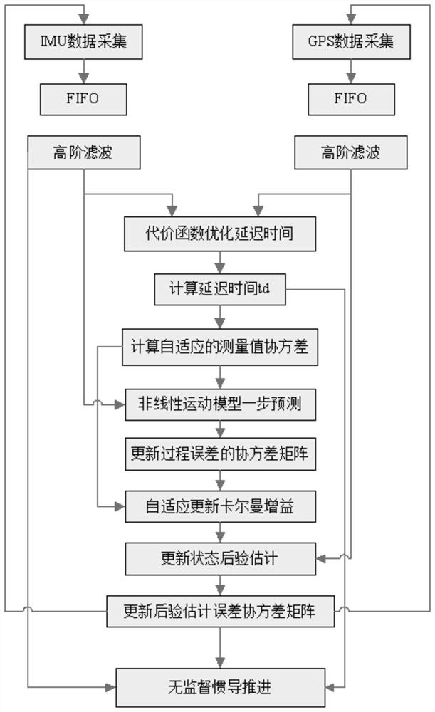
[0057] In order to make the technical solution of the present invention clearer and clearer to those skilled in the art, the technical solution of the present invention will be described in detail below in conjunction with the accompanying drawings, but the embodiments of the present invention are not limited thereto.

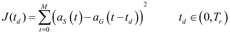
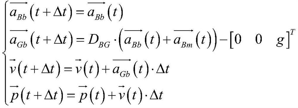
[0058] In order to overcome the adverse effects of GPS measurement time delay on the solution accuracy of integrated navigation parameters, the purpose of the present invention is to provide an integrated navigation algorithm that takes GPS measurement delay time into account, even if there is a random delay in GPS measurement time, it can still make The measured value of GPS and the measured value of MEMS sensor can be adaptively aligned in the historical time, which provides a good guarantee for the solution process of subsequent navigation parameters.

[0059] In order to achieve the above object, the technical scheme adopted in the present invention is:

[...


PUM


Abstract

The invention belongs to the field of self-adaptive integrated navigation algorithms, and particularly relates to an INS/GPS self-adaptive integrated navigation algorithm when delay exists in measuredspeed and position. On the basis of cached historical IMU data and GPS data, the invention provides a method for extracting GPS speed and position measurement delay time through a cost function optimization algorithm, and the problem of GPS/IMU data alignment can be effectively solved. In the process of executing the GPS/INS extended Kalman filter integrated navigation algorithm, the self-adaptive adjustment of the error covariance of the measured value is carried out based on the delay time, so that the navigation precision under the environment of large delay of the measured value is effectively improved.

Description

technical field [0001] The invention belongs to the field of adaptive integrated navigation algorithms, in particular to an INS / GPS adaptive integrated navigation algorithm when the measured speed and position are delayed. Background technique [0002] In recent years, with the development of unmanned vehicles and unmanned aerial vehicles, higher and higher requirements have been put forward for the accuracy of navigation parameters such as attitude, speed, and position of vehicles. Accurate and reliable navigation algorithm is the prerequisite for unmanned guidance of the carrier. [0003] In the civilian field, most of the low-cost MEMS inertial navigation sensors are used for navigation, but due to the low precision of low-cost MEMS sensors, only relying on MEMS sensors for navigation will cause the calculation process to diverge easily; if pure GPS navigation is used, there will be signal Due to the shortcomings of occlusion failure, signal delay, and low navigation fre...

Claims


Application Information

Patent Timeline
Patent Type & Authority Applications(China)
IPC IPC(8): G01C21/20G01C21/16G01S19/14
CPCG01C21/20G01C21/165G01S19/14
Inventor 刘月娟赵秋玲丁晓玲张威吕英杰
Owner QINGDAO TECHN COLLEGE
Why Eureka
Try Eureka