Method for quickly constructing spatial topological relation of vector earth surface coverage pattern spot and storage medium

A technology of surface coverage and spatial topology, applied in the field of geographic information, can solve the problem of surface patch identification and unified edge processing that cannot be partitioned, and the extraction of topological relations of patch data with low efficiency and difficulty in computing topological adjacency table. problems such as storage organization and application analysis, to achieve the effect of speeding up search, speeding up processing, and reducing task time-consuming

Active Publication Date: 2020-12-18
CHINESE ACAD OF SURVEYING & MAPPING
View PDF7 Cites 7 Cited by
  • Summary
  • Abstract
  • Description
  • Claims
  • Application Information

AI Technical Summary

Problems solved by technology

These technologies often exceed the technical level of ordinary operators, and it is difficult to sequentially complete topological relationship extraction, storage organization and application analysis for complex map data
[0010] (2) The topological adjacency table calculation function provided by mainstream software is inefficient and does not support distributed deployment
When dealing with vector graphics spots with a scale of 100 million, although parallel modules can be developed on the basis of ArcGIS software for parallel processing of independent partitions, it is impossible to identify and uniformly process the polygonal spots at the edge of the partitions.

Method used


Image

  • Method for quickly constructing spatial topological relation of vector earth surface coverage pattern spot and storage medium
  • Method for quickly constructing spatial topological relation of vector earth surface coverage pattern spot and storage medium
  • Method for quickly constructing spatial topological relation of vector earth surface coverage pattern spot and storage medium

Examples


Embodiment 1

[0093] Example 1: Statistical Calculation of Minimum Speckle Threshold Limitation

[0094] When implementing spatial statistics, the size of the spots involved in area calculation is generally limited. However, since the data production is mostly carried out according to different partitions (connected to the chart), the real plots located at the border and belonging to the same land type are divided into different task areas. When calculating the area, the marginal map spots are generated due to the division of the border of the chart or the administrative unit, and then are omitted from the calculation, resulting in a small overall statistical result. The general processing system usually uses the method of spatial union (Union) to fuse patches of the same land type, but this process is extremely time-consuming, and the mainstream ArcGIS software is still difficult to support the fusion processing of patches with a scale of more than one million levels. Based on the method ...

Embodiment 2

[0096] Example 2: Infrastructure Proximity Analysis

[0097] In the full-coverage surface elements, it is often necessary to count the proximity of the patches of cultivated land, forest land, and pasture land to rivers or roads. That is, which plots can be directly adjacent to the river network or road network, which is an important parameter to measure and evaluate the quality and location conditions of plots.

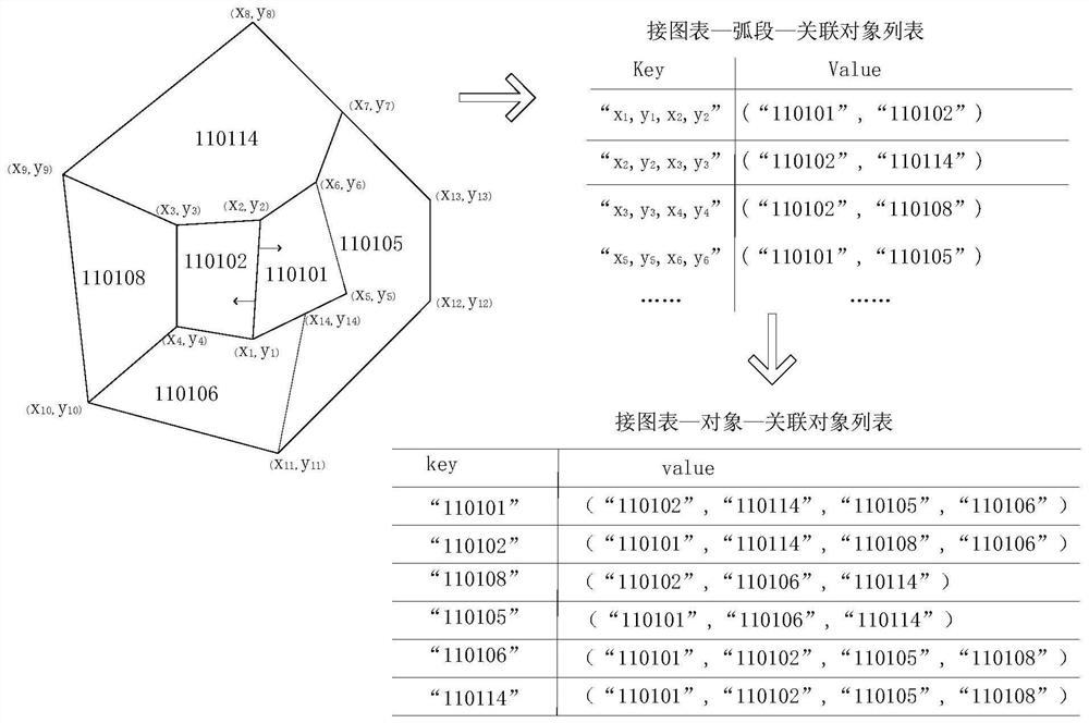
[0098] After constructing the topological adjacency relationship based on the method of the present invention, other map spots that have an adjacency relationship with them can be queried directly based on the map spot identification of the river network and the road network. Such as Figure 7 As shown, the cultivated land directly adjacent to the river K includes plots B, C, and G, which belong to high-quality cultivated land, while J is far away and cannot be directly irrigated.

[0099] The present invention also discloses a storage medium for storing computer-e...


PUM


Abstract

The invention discloses a method for quickly constructing a spatial topological relation of a vector earth surface coverage pattern spot and a storage medium. The method comprises the following steps:constructing an edge topological relation network of a task graph, extracting the construction and edge relation of the topological relation in a task area, and carrying out edge connection and storage on the topological relation between the task areas. The data structure based on a hash table structure is used for constructing the topological relation between the chart and the task area, and thekey code value is mapped to one position in the chart to access the record, so that the searching speed is increased. Thousands of sub-tasks are constructed according to an index structure, namely atask partition graph, of the spatial graphic data, parallel driving can be conducted through multiple machines and multiple processors, accelerated processing is achieved, and task time consumption isreduced.

Description

technical field [0001] The present invention relates to the field of geographic information, in particular to a method for rapidly constructing spatial topological relations of vector surface coverage map spots and a storage medium. Background technique [0002] Topological relationship refers to the relationship between spatial data that satisfies the principle of topological geometry. That is, the adjacency, association, containment and connectivity relationships between entities represented by nodes, arcs and polygons. Such as: point-to-point adjacency relationship, point-to-surface containment relationship, line-to-surface separation relationship, surface-to-surface coincidence relationship, etc. Among them, the adjacency relationship and association relationship are the basic spatial relationships that are widely used and the construction process is the most time-consuming. With the wide application of spatial data in different fields, the demand for 2D and 3D browsin...

Claims


Application Information

Patent Timeline
Patent Type & Authority Applications(China)
IPC IPC(8): G06F16/29G06F16/2458G06F16/22
CPCG06F16/29G06F16/2458G06F16/22
Inventor 亢晓琛董春杨毅赵荣康风光
Owner CHINESE ACAD OF SURVEYING & MAPPING
Why Eureka
Try Eureka