Method for establishing flood disaster geographical analysis and evaluation dynamic model

A dynamic model and flood disaster technology, applied in geographic information database, electrical digital data processing, structured data retrieval, etc., to achieve the effect of simulating reality, ensuring scientificity, and complete functions

Inactive Publication Date: 2014-07-16
BEIJING ZHONGYOULIAN TECH
View PDF4 Cites 32 Cited by
  • Summary
  • Abstract
  • Description
  • Claims
  • Application Information

AI Technical Summary

Problems solved by technology

The evaluation results of this method are in line with reality, but it is suitable for the application of large spatial scales with relatively complete information

Method used


Image

  • Method for establishing flood disaster geographical analysis and evaluation dynamic model

Examples


Embodiment Construction

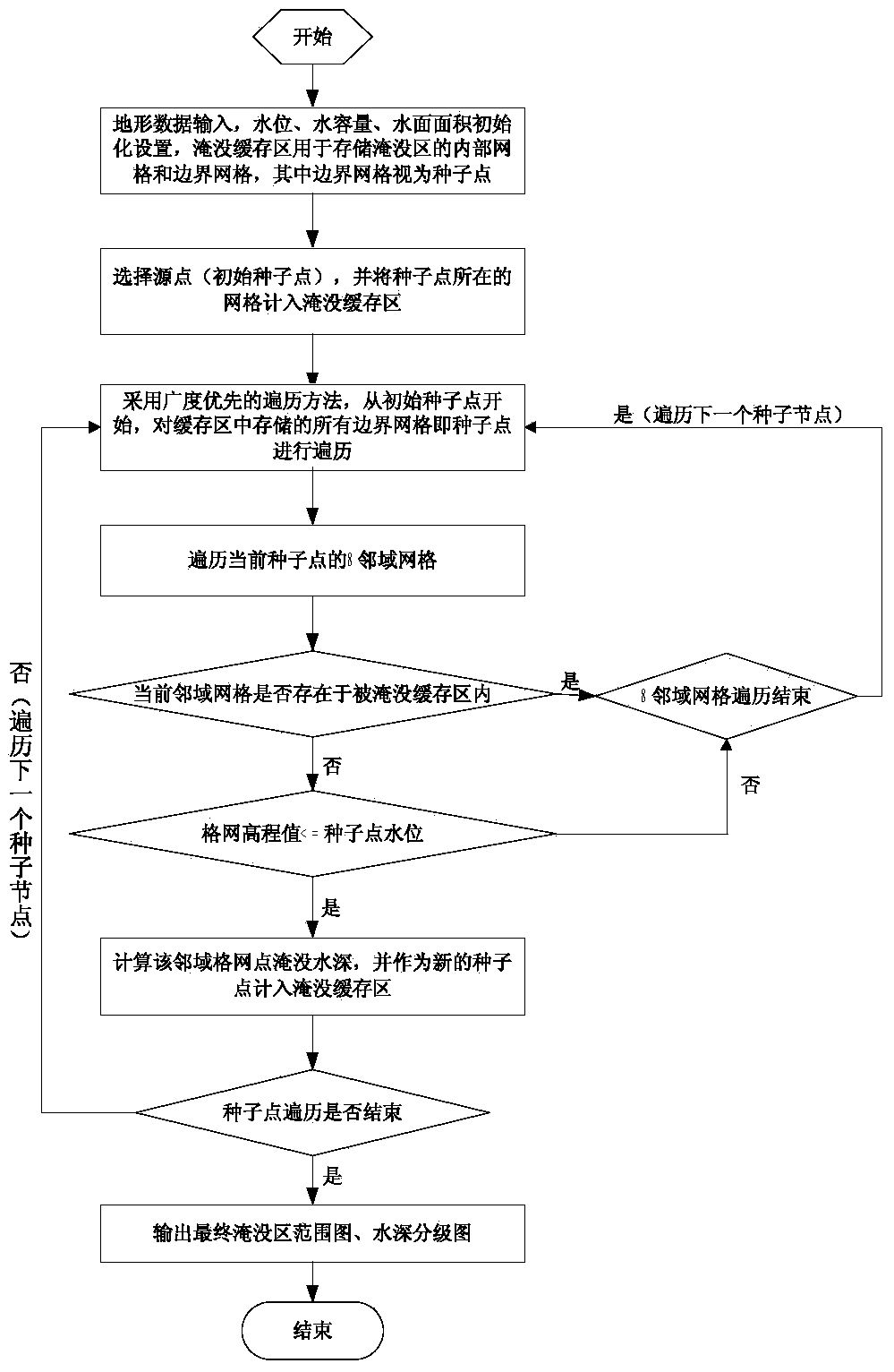
[0041] The present invention will be further described in detail below in conjunction with the accompanying drawings, so that those skilled in the art can implement it with reference to the description.

[0042] The invention provides a method for constructing a dynamic model for geographic analysis and evaluation of flood disasters, including:

[0043] Step 1. Collect the spatial data of the area to be analyzed and the attribute data associated with the spatial data as initial data, and store the initial data in the created lightweight spatial database after compression. The database creation steps include:

[0044] Build an image pyramid. The resolution of the image pyramid is reduced from the bottom layer to the top layer. The 0 layer of the image pyramid stores uncompressed initial data without any data loss. The first layer of the image pyramid stores compressed initial data. Each image The size of the pyramid depends on the size of the initial data. When reading the com...


PUM


Abstract

The invention relates to the field of disaster information management, in particular to a method for establishing a flood disaster geographical analysis and evaluation dynamic model. The method includes the steps that initial data of a region to be analyzed are collected, compressed and then stored in an established lightweight class spatial database; the initial data are retrieved, an established flood inundation analysis model is initialized, and a final flood inundated region areal map and a water depth classification map are acquired through a seed point spreading algorithm; integrated data of the final flood inundated region areal map and the water depth classification map are input to a flood disaster loss evaluation mathematical model and a flood risk evaluation mathematical model for calculation, and then the economic loss condition and the potential flood-hit risk degree of villages in a flood storage and detention region after flood inundation are acquired. A spatial database system and the flood inundation analysis model which are excellent in performance and stable and reliable in operation are established, the organization and management method of image raster data is optimized, the flood inundation condition of the flood storage and detention region under a given condition is visually displayed, and the consequential loss evaluation function is provided.

Description

technical field [0001] The invention relates to the field of disaster information management, in particular to a method for constructing a dynamic model for geographic analysis and evaluation of flood disasters. Background technique [0002] Flood disaster is one of the natural disasters that occur most frequently and seriously threaten human survival and development. Flood disasters are characterized by complexity, high frequency of occurrence, wide range of influence, and large losses. The number of casualties caused by flood disasters in the world exceeds 65% of all casualties caused by natural disasters every year, and the losses caused by floods exceed 30% of all losses due to natural disasters. Flood disasters have become a major problem faced and concerned by human society. my country is the largest developing country in the world and one of the countries most affected by flood disasters in the world. According to incomplete statistics, an average of more than 100 ...

Claims


Application Information

Patent Timeline
Patent Type & Authority Applications(China)
IPC IPC(8): G06F17/30
CPCG06F16/29Y02A10/40
Inventor 霍亮
Owner BEIJING ZHONGYOULIAN TECH
Why Eureka
Try Eureka