Efficient construction method of hyperspectral remote sensing data compression and classification model

A hyperspectral remote sensing and data compression technology, which is applied in the field of hyperspectral remote sensing data compression and classification model construction, can solve the problems of decompression that consumes a lot of time, the impact of real-time classification, and does not consider the real-time performance of application scenarios. Classification speed, the effect of increasing the speed of compression and reconstruction and classification

Active Publication Date: 2020-12-29
CHINA UNIV OF GEOSCIENCES (WUHAN)
View PDF16 Cites 4 Cited by
  • Summary
  • Abstract
  • Description
  • Claims
  • Application Information

AI Technical Summary

Problems solved by technology

[0003] Some existing hyperspectral data lossy compression algorithms play an important role in reducing storage device cost and bandwidth, and the decompressed data has good performance in applications such as HS image classification, but the data decompression and feature Re-extraction takes a lot of time, which affects the real-time performance of classification
Since the existing hyperspectral data lossy compression algorithms hardly consider the real-time performance of application scenarios such as classification, it is necessary to find an efficient method to achieve real-time compression and classification of hyperspectral data

Method used


Image

  • Efficient construction method of hyperspectral remote sensing data compression and classification model
  • Efficient construction method of hyperspectral remote sensing data compression and classification model
  • Efficient construction method of hyperspectral remote sensing data compression and classification model

Examples


Embodiment Construction

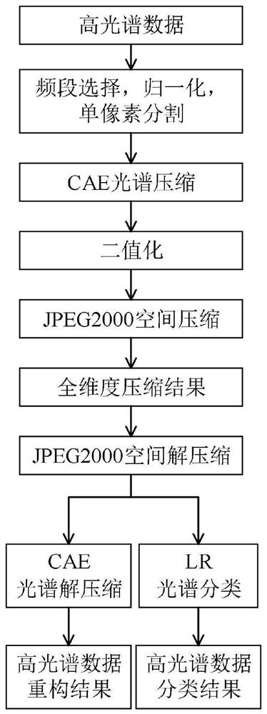
[0038] In order to make the purpose, technical solution and advantages of the present invention clearer, the embodiments of the present invention will be further described below in conjunction with the accompanying drawings.

[0039] Please refer to figure 1 , a kind of efficient hyperspectral remote sensing data compression and the construction method of classification model provided by the present invention, concrete steps are as follows:

[0040] S1: Use the spaceborne hyperspectral sensor to collect ground hyperspectral remote sensing data. The hyperspectral remote sensing data used is collected by the AVIRIS hyperspectral sensor at the IndianPines test site in the northwest of Indiana, USA. It contains 224 frequency bands, called IndianPines.

[0041] S2: Preprocess the hyperspectral remote sensing data collected by S1, remove the frequency bands of the water absorption band and some frequency bands with low signal-to-noise ratio in the spectrum of the IndianPines dataset. ...


PUM


Abstract

The invention provides an efficient construction method of hyperspectral remote sensing data compression and a classification model which comprises the following specific steps: preprocessing originalhyperspectral data, and segmenting the original hyperspectral data into single hyperspectral pixels; designing the output of the coding part of the full convolution automatic encoder network into binary output to obtain an automatic encoder CAE with efficient spectrum compression, and designing a joint deep learning network CAELR with efficient spectrum compression and rapid classification by combining the CAE with a logistic regression LR classifier; combining CAELR and JPEG2000 to design a method CAELR + JP2 with spectrum and space full-dimension compression and classification; combining the trained CAELR with JPEG2000 to carry out rate distortion optimization so as to realize the optimal rate distortion performance of the CAELR + JP2 under each bit rate; the CAELR + JP2 model designedby the invention effectively improves the compression and classification precision and speed of the hyperspectral data between the satellite-borne hyperspectral sensor and the ground receiving station.

Description

technical field [0001] The invention relates to the fields of aerospace technology and artificial intelligence technology, in particular to an efficient hyperspectral remote sensing data compression and classification model building method. Background technique [0002] Hyperspectral remote sensing is a technology that uses a narrow and continuous spectral channel to continuously image ground objects. In the visible light to short-wave infrared band, its spectral resolution is as high as nanometers, and it usually has the characteristics of multiple bands, with dozens or even hundreds of spectral channels, and the spectral channels are often continuous. Hyperspectral data has gradually become a valuable tool for monitoring the Earth's surface and is used in a wide variety of application scenarios, including agriculture, mineralogy, monitoring, physics, astronomy, and environmental science. Gaofen-5, which was officially put into use in March 2019, is the remote sensing sate...

Claims


Application Information

Patent Timeline
Patent Type & Authority Applications(China)
IPC IPC(8): G06K9/62G06N3/04G06N3/08
CPCG06N3/08G06N3/045G06F18/214G06F18/241Y02A40/10
Inventor 蒋伟陈分雄许祎晗廖森辉韩荣王杰熊鹏涛叶佳慧
Owner CHINA UNIV OF GEOSCIENCES (WUHAN)
Why Eureka
Try Eureka