
Soil quick-acting potassium analysis model construction system and method based on satellite images

A satellite image and analysis model technology, applied in genetic models, analysis materials, neural learning methods, etc., can solve the problems of high uncertainty and randomness in parameter adjustment, and achieve the effect of avoiding excessive investment and reducing costs.

Inactive Publication Date: 2020-12-29
哈尔滨航天恒星数据系统科技有限公司
View PDF5 Cites 6 Cited by
  • Summary
  • Abstract
  • Description
  • Claims
  • Application Information

AI Technical Summary

Problems solved by technology

[0004] In order to solve the problems of large randomness and high uncertainty of parameter adjustment in the traditional BP neural network in soil content collection and monitoring, the present invention proposes a soil available potassium analysis model building system and method based on satellite images, and the specific scheme is as follows:

Method used


Image

  • Soil quick-acting potassium analysis model construction system and method based on satellite images
  • Soil quick-acting potassium analysis model construction system and method based on satellite images
  • Soil quick-acting potassium analysis model construction system and method based on satellite images

Examples


specific Embodiment approach 1

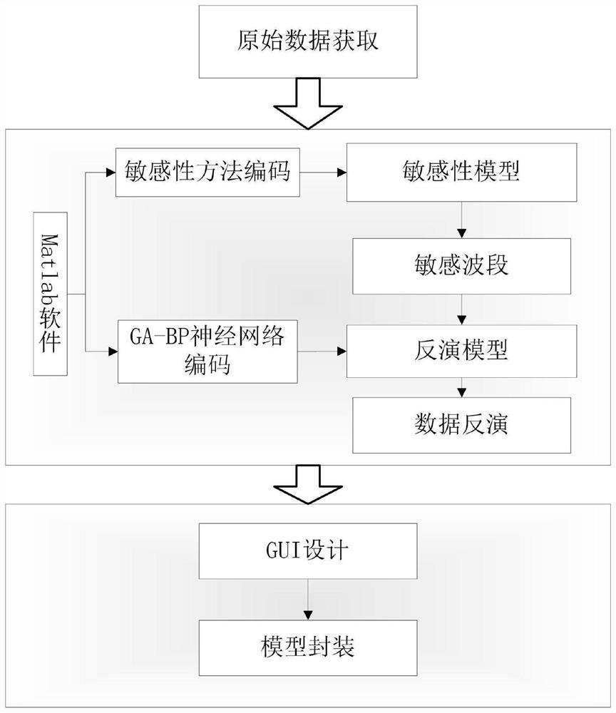
[0047] Embodiment 1: The soil available potassium analysis model construction system based on satellite images, through the raw data acquisition module, image band construction module, sensitive band conversion module, conversion band analysis module, parameter input module, neural network construction module and model training verification The progressive parameter data of the module is combed, and the neural network model for the analysis of soil available potassium is constructed, and finally the analysis results of various parameters of soil available potassium are realized.

specific Embodiment approach 2

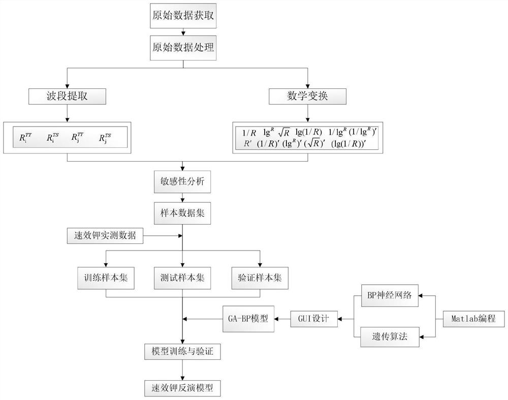
[0048] Specific implementation mode two: the specific implementation steps of the method for the construction of soil available potassium analysis model based on satellite images are as follows:

[0049] Step 1, raw data acquisition:

[0050]In accordance with the requirements of the "Technical Specifications for Soil Sample Collection", the soil samples in the target area were collected, packaged and calibrated. The soil sample points in the target area were collected, and the 0-20cm plow layer soil in the operation area was collected by the equidistant sampling method. Take 1kg of soil after fully mixing and evenly. The sampling interval is determined according to the size of the operation range. Generally, the interval of dry fields is 100m, and each grid of paddy fields is evenly distributed with 9 points. Use GPS to obtain the longitude, latitude and elevation information of the sampling points. After the sampling is completed, the soil samples enter the laboratory for p...

specific Embodiment approach 3

[0067] Specific implementation mode three: combined with attached Figure 1-8 Illustrate the soil available potassium analysis model building system based on satellite imagery, the present invention is example with the farmland of certain province, adopts the method of the present invention, finally obtains the soil available potassium content distribution map of arable land, and specific implementation scheme is as follows:

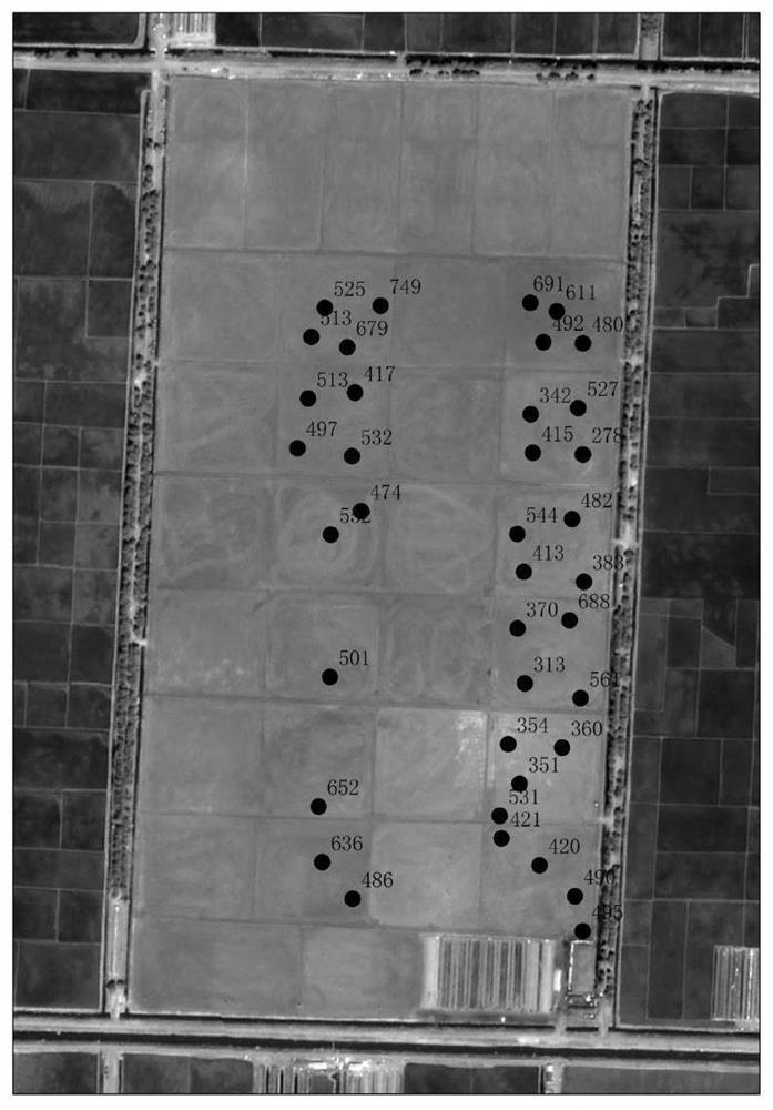
[0068] A farm has an experimental field of 475 mu. According to the actual local conditions, soil samples are collected, the latitude and longitude coordinates of each sampling point and the number of soil samples are recorded, and the soil samples are sent to a professional third-party soil testing laboratory for testing. Available potassium content, measured content (mg / kg) and location are shown in the figure below (note: the data marked on the figure is the content of available potassium):

[0069] Query and download remote sensing images. This examp...


PUM


Abstract

The invention relates to a soil quick-acting potassium analysis model construction system and method based on satellite images, belongs to the technical field of remote sensing technologies and variable fertilization, and aims to solve the problems of high randomness and high parameter adjustment uncertainty of a traditional BP neural network in soil content acquisition and monitoring. The systemcomprises an original data acquisition module, an image wave band construction module, a sensitive wave band transformation module, a transformation wave band analysis module and the like. The methodcomprises the following steps: acquiring a soil sample in a target area according to requirements of soil sample acquisition technical specifications, then preprocessing an image waveband, carrying out mathematical transformation on a sensitive waveband, finally training a neural network model in a model training verification module, and carrying out verification analysis on an obtained result; accurate and comprehensive fertilization is realized, and the cost is reduced, so that excessive cost input and environmental pollution caused by excessive fertilization are avoided, soil hardening caused by excessive fertilization is avoided, and crop growth is reasonably and efficiently promoted.

Description

technical field [0001] The invention relates to a system and method for building a soil available potassium analysis model based on satellite images, in particular to building a soil available potassium analysis model based on satellite images, and belongs to the technical field of remote sensing technology and variable fertilization. Background technique [0002] At present, in the detection of soil available potassium, it is generally to measure the available potassium content of the entire farmland soil by using "point" instead of "surface" through on-site soil testing. This method requires a large amount of soil testing data to be collected on site. Also consume a large amount of manpower and material resources, increase production cost, and precision is difficult to guarantee. [0003] In recent years, with the development of space technologies such as satellite remote sensing and UAV remote sensing, digital agricultural technology has been greatly improved, and the app...

Claims


Application Information

Patent Timeline
Patent Type & Authority Applications(China)
IPC IPC(8): G06N3/08G06N3/12G01N21/84G01N1/04G01N1/38
CPCG01N1/04G01N1/38G01N21/84G06N3/084G06N3/126
Inventor 宋振强梁志国葛宝玉高磊王众娇程飞雁曲中华
Owner 哈尔滨航天恒星数据系统科技有限公司
Learn More