
Measurement, operation and control system and method for low-orbit satellite constellation

A low-orbit satellite and constellation technology, applied in the field of satellite positioning, can solve the problems of antennas needing mutual follow-up tracking, difficulties in antenna development, and difficult policies, etc., to reduce the complexity of satellite technology, reduce satellite complexity and cost, and develop simple effect

Inactive Publication Date: 2020-12-29
QIANXUN SPATIAL INTELLIGENCE INC
View PDF5 Cites 8 Cited by
  • Summary
  • Abstract
  • Description
  • Claims
  • Application Information

AI Technical Summary

Problems solved by technology

[0004] However, the above-mentioned global station deployment and inter-satellite link schemes have obvious defects
Among them, for the global station deployment plan, it is necessary to build a ground system capable of measuring, operating and controlling a low-orbit satellite system with global coverage. It is necessary to establish no less than 40 ground stations around the world. The more the number of ground stations, the higher the cost , and it is necessary to establish an overseas ground station with uplink and downlink, and it is necessary to obtain a radio transmission license overseas, and the policy is difficult; and for the inter-satellite link solution, each satellite on the constellation needs to be equipped with a total of four antennas in front, back, left, and right According to the orbital characteristics, the positions of the front and rear satellites in the same orbital plane are relatively fixed, and the antenna pointing is fixed. The project is simple to implement, but the positions of the left and right satellites in different orbital planes continue to change, and the antennas need to track each other. The development of the antenna is difficult and the cost is high.
Therefore, the current solution for real-time measurement, operation and control of low-orbit satellite constellations is complex and costly

Method used


Image

  • Measurement, operation and control system and method for low-orbit satellite constellation
  • Measurement, operation and control system and method for low-orbit satellite constellation
  • Measurement, operation and control system and method for low-orbit satellite constellation

Examples


Embodiment Construction

[0041] In the following description, many technical details are proposed in order to enable readers to better understand the application. However, those skilled in the art can understand that the technical solutions claimed in this application can be realized even without these technical details and various changes and modifications based on the following implementation modes.

[0042] Explanation of some concepts:

[0043] Low-orbit satellite system: distance from the ground (500-2000) Km, transmission delay and power consumption are relatively small, but the coverage of each satellite is also relatively small, a typical system is Motorola's Iridium system. Due to the low satellite orbit and short signal propagation delay, the low-orbit satellite communication system can support multi-hop communication, and its link loss is small, which can reduce the requirements for satellites and user terminals. Micro / small satellites and handheld user terminals can be used. However, the lo...


PUM


Abstract

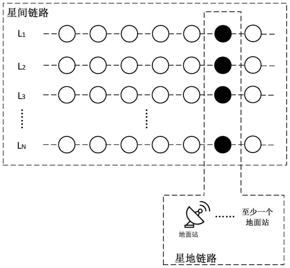
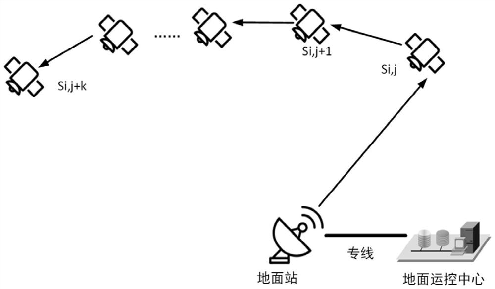
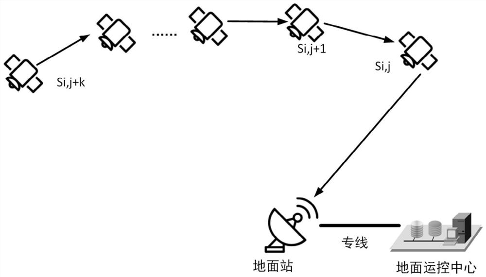
The invention relates to a satellite positioning technology, and discloses a measurement, operation and control system and method for a low-orbit satellite constellation. The measurement, operation and control system comprises N common-orbit inter-satellite links corresponding to N orbital planes, each common-orbit inter-satellite link is used for data transmission between node satellites of the corresponding orbital plane, and N is larger than or equal to 2; and the system further comprises a satellite-ground link which is used for specifying the node satellites running to the intersection ofthe N orbital planes in each common-orbit inter-satellite link as hub satellites, and each common-orbit inter-satellite link performs data transmission with at least one ground station arranged nearthe latitude of the intersection of the N orbital planes through the hub satellites. According to the embodiment of the invention, while the low-orbit satellite constellation measurement, operation and control requirements are met, the technical complexity of the satellite is reduced, the cost of the satellite and the ground station is reduced, and the engineering feasibility of real-time measurement, operation and control of the low-orbit satellite constellation is improved.

Description

technical field [0001] This application relates to the field of satellite positioning, in particular to the measurement, operation and control technology of low-orbit satellite constellations. Background technique [0002] The low-orbit satellite constellation is generally a constellation system with global coverage. At present, the main applications are global broadband communication, navigation enhancement, voice communication, etc. These application scenarios require real-time interaction between the satellite and the ground operation and control system, that is, the requirements: Regardless of the location, the ground measurement, operation and control system has the ability to exchange data with any satellite system and complete business control. [0003] At present, the following two methods are used for real-time measurement, operation and control of low-orbit satellite constellations: the first one is to deploy stations globally, and to establish ground stations arou...

Claims


Application Information

Patent Timeline
Patent Type & Authority Applications(China)
IPC IPC(8): H04B7/185
CPCH04B7/18519H04B7/18513H04B7/18521
Inventor 丁菲
Owner QIANXUN SPATIAL INTELLIGENCE INC
Learn More