Underground water intelligent supervision platform based on three-dimensional geological model
A 3D geology and 3D model technology, applied in the field of information network, can solve the problem that the groundwater monitoring and early warning platform cannot meet the three-dimensional display of ground and underground and the comprehensive analysis of plane and three-dimensional monitoring data
- Summary
- Abstract
- Description
- Claims
- Application Information
AI Technical Summary
Problems solved by technology
Method used
Image
Examples
Embodiment 1
[0053] Example 1: Realization of data docking
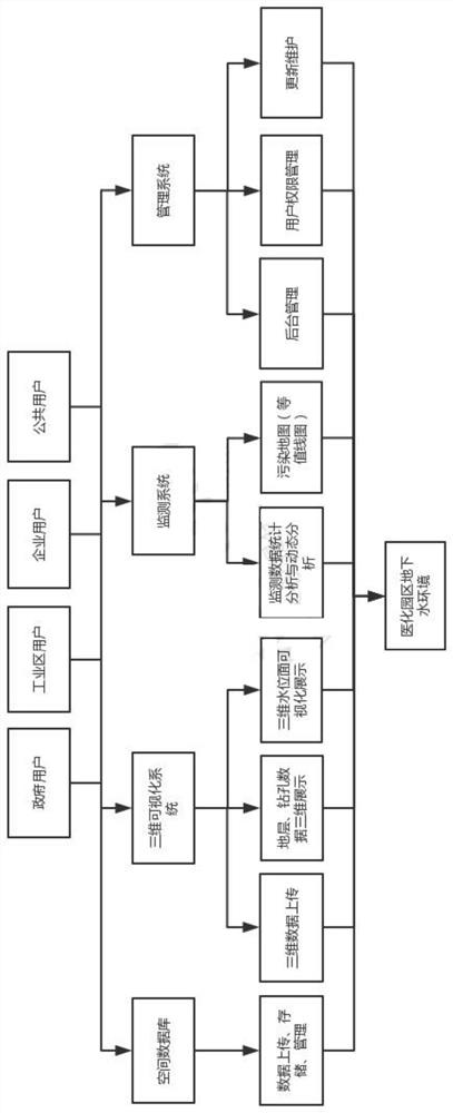
[0054] For the data stored in the platform, the convenient import and export functions are used to read and save the data, without the need to transfer the data manually, and the mutual transfer of data is realized through common data storage modes such as Excel and Txt. The convenience of data docking is crucial to the adaptability, versatility, and timeliness of the system, especially the management of massive data, and it also facilitates the transformation from traditional data management mode to cloud management mode. At the same time, the platform supports the export of PGF files required by geological modeling software, and the exported PGF files can be directly modeled, saving a lot of data processing time.
Embodiment 2
[0055] Embodiment 2: Realization of 3D data upload
[0056]3D data upload mainly refers to the upload and management of 3D models, including the upload and lightweight of geological models (EVS 3D geological models in the format of eff), 3D artificial models (mainly referring to those in the formats of Fbx, Obj, 3ds, Dae, etc. Model) upload and lightweight, upload and storage of 3D Tiles models, where 3D Tiles models refer to all models in 3D Tiles format, which can be BIM models or oblique photography models, etc.
Embodiment 3
[0057] Embodiment 3: Realization of monitoring data
[0058] Based on monitoring data, statistical analysis and dynamic analysis are carried out. Statistical analysis of monitoring data mainly refers to the analysis of individual monitoring indicators of statistical groundwater monitoring data, including maximum, minimum, average, median, and number of exceeding standards. Dynamic analysis of monitoring data mainly refers to drawing dynamic curves of individual monitoring indicators over time, and grasping the dynamic change law of monitoring data at monitoring points, so as to find abnormalities in groundwater environment in time.
PUM
 Abstract
Description
Claims
Application Information
 - R&D
- Intellectual Property
- Life Sciences
- Materials
- Tech Scout
- Unparalleled Data Quality
- Higher Quality Content
- 60% Fewer Hallucinations
Browse by: Latest US Patents, China's latest patents, Technical Efficacy Thesaurus, Application Domain, Technology Topic, Popular Technical Reports.
© 2025 PatSnap. All rights reserved.Legal|Privacy policy|Modern Slavery Act Transparency Statement|Sitemap|About US| Contact US: help@patsnap.com

