Semantic segmentation-based point cloud intensity completion method and system

A semantic segmentation and completion technology, applied in image enhancement, image analysis, image data processing, etc., can solve the problems of beam energy loss, received signal weakening, lack of reference, etc.

Active Publication Date: 2021-01-05
TSINGHUA UNIV
View PDF18 Cites 4 Cited by
  • Summary
  • Abstract
  • Description
  • Claims
  • Application Information

AI Technical Summary

Problems solved by technology

Long-distance objects cannot return the beam or the energy of the returned beam is lower than the detection threshold; in addition, affected by the microscopic particles in the atmosphere, weather conditions such as rain, snow and fog will cause the energy loss of the beam emitted by the lidar, resulting in the object being unable to return the beam or return the energy of the beam below detection threshold
Both of these conditions will eventually result in the receiver not being able to receive the signal, the received signal being weakened or doped with noise
[0004] The current point cloud completion work mainly has the following limitations: (1) limited to the point cloud completion of local objects, especially the completion of indoor scenes or single objects; (2) limited to the completion of local dependencies, that is, based on phase (3) In the completion of large-scale overall scenes, the focus is on depth completion, while less research has been done on reflection intensity completion

Method used


Image

  • Semantic segmentation-based point cloud intensity completion method and system
  • Semantic segmentation-based point cloud intensity completion method and system
  • Semantic segmentation-based point cloud intensity completion method and system

Examples


Embodiment 1

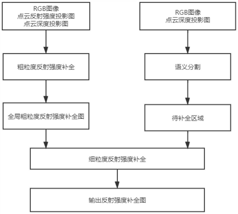
[0083] like figure 1 As shown, Embodiment 1 of the present invention proposes a point cloud intensity complement method based on semantic segmentation, and the specific implementation steps are as follows:

[0084] Step 1) Obtain the three-channel RGB image and point cloud data of the same scene respectively through the monocular camera and the lidar; specifically include:

[0085] Step 101) obtain the RGB image CI of road condition by vehicle-mounted monocular camera;

[0086] The image information of the front scene is collected by a forward-facing monocular camera or a forward-facing monocular camera installed on a driving vehicle. The forward-facing monocular camera collects road surface image information directly in front of the driving direction of the vehicle and above the road surface. That is, the collected road surface image information is a perspective view corresponding to information directly in front of the driving direction of the collected vehicle and above t...

Embodiment 2

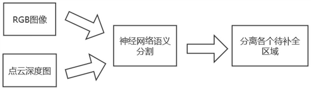
[0147] Based on the above method, Embodiment 2 of the present invention proposes a point cloud intensity complement system based on semantic segmentation, which mainly includes a camera, a laser radar, and four modules, which are respectively a point cloud data preprocessing module, a coarse-grained reflection intensity complement Full module, semantic segmentation module, and fine-grained reflection intensity completion module, among which:

[0148] A camera for collecting RGB images of the road surface;

[0149] LiDAR, for synchronous collection of point cloud data of the road surface;

[0150] Point cloud data preprocessing module: According to the laser radar point cloud data, based on the calibration results of radar and camera, the three-dimensional point cloud is spatially transformed to generate a single-channel two-dimensional reflection intensity projection map and a single-channel two-dimensional depth projection map;

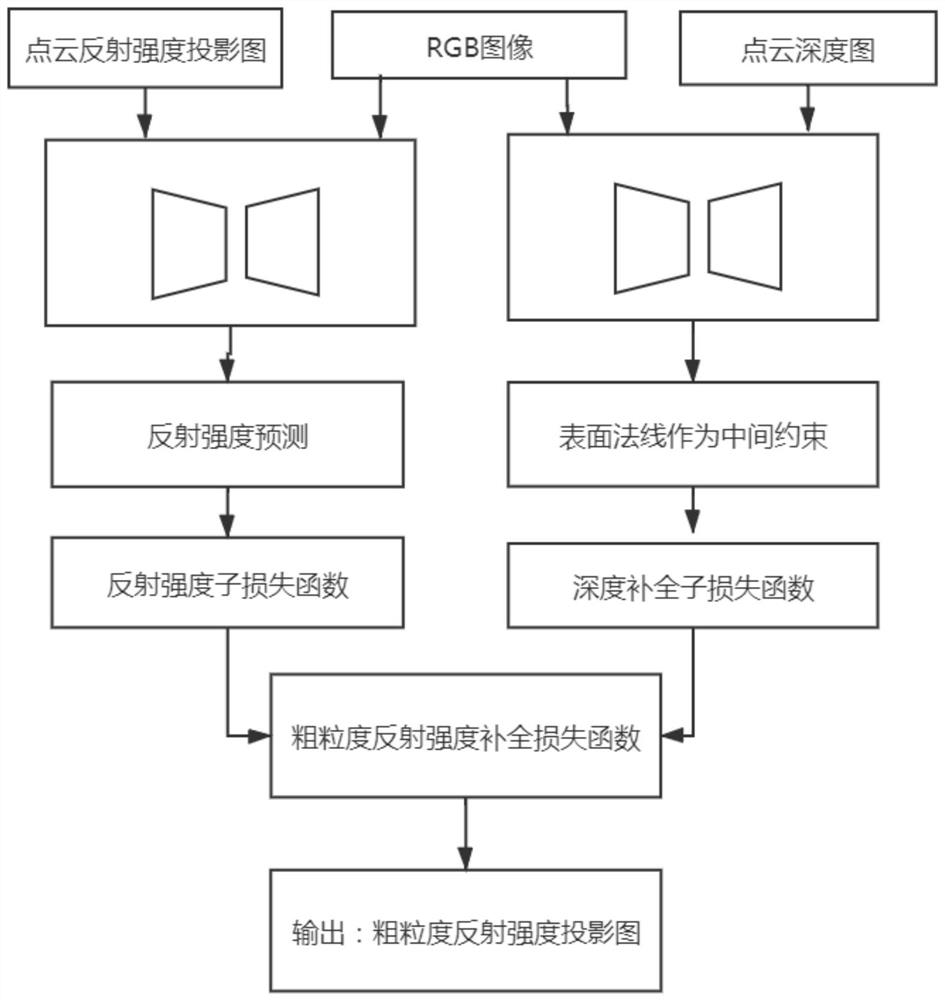
[0151] Coarse-grained reflection intensity co...


PUM


Abstract

The invention discloses a semantic segmentation-based point cloud intensity completion method and system. The method comprises the steps of synchronously acquiring an RGB image and point cloud data ofa road surface by a camera and a laser radar; performing spatial transformation on the point cloud data by utilizing the transformation matrix to generate a two-dimensional reflection intensity projection drawing and a two-dimensional depth projection drawing; performing reflection intensity completion on the RGB image and the two-dimensional reflection intensity projection drawing to obtain a single-channel reflection intensity projection drawing; performing depth completion on the RGB image and the two-dimensional depth projection drawing to obtain a single-channel depth projection drawing;performing coarse-grained completion processing on the RGB image, the single-channel reflection intensity projection drawing and the single-channel depth projection drawing to obtain a two-dimensional coarse-grained reflection intensity projection drawing; performing semantic segmentation processing on the RGB image and the two-dimensional depth projection drawing to obtain a plurality of regionsto be completed; and performing fine-grained reflection intensity completion on the two-dimensional coarse-grained reflection intensity projection drawing according to the to-be-completed regions toobtain a two-dimensional reflection intensity projection completion drawing.

Description

technical field [0001] The invention belongs to the field of unmanned driving, and in particular relates to a point cloud intensity complement method and system based on semantic segmentation. Background technique [0002] Lidar is the main tool for unmanned driving data collection. Lidar on the roof of unmanned vehicles generally has 16 / 32 / 64 / 128 line lidar. The cost of lidar increases with the number of lines, but less The lidar of the wire harness collects less point clouds, and the sparse point clouds are difficult to use for high-precision calculations. [0003] In addition, in actual acquisition, the energy of the lidar return beam is affected by distance and propagation medium. Long-distance objects cannot return the beam or the energy of the returned beam is lower than the detection threshold; in addition, due to the influence of microscopic particles in the atmosphere, meteorological conditions such as rain, snow and fog will cause the energy loss of the beam emitt...

Claims


Application Information

Patent Timeline
IPC IPC(8): G06T5/00G06T5/50G06T3/40G06T7/11G06T7/13
CPCG06T5/50G06T3/4038G06T7/11G06T7/13G06T2207/10024G06T2207/10028G06T2207/20081G06T2207/20084G06T2207/20221G06T2207/30256G06T5/77G06V20/56G06V10/82G06T7/187G06T7/521G06T3/4007G06T3/60G06T2207/30252
Inventor 李骏张新钰李志伟邹镇洪赵文慧
Owner TSINGHUA UNIV
Why Eureka
Try Eureka