Traffic difficulty area sedimentary carbonate lead-zinc ore survey method and system, equipment and application

A lead-zinc mine, a difficult technology, applied in the field of remote sensing identification of mineral resources, to achieve the effects of high geometric resolution, reduced exploration costs, and clear surface objects

Pending Publication Date: 2021-02-19
XI'AN UNIVERSITY OF ARCHITECTURE AND TECHNOLOGY +1
View PDF0 Cites 3 Cited by
  • Summary
  • Abstract
  • Description
  • Claims
  • Application Information

AI Technical Summary

Problems solved by technology

[0008] The current survey method is more effective for some structural ore-hosting deposits, but it is ineffective for deposits produced by sedimentation, especially secondary oxidized carbonatite-type lead-zinc deposits

Method used


Image

  • Traffic difficulty area sedimentary carbonate lead-zinc ore survey method and system, equipment and application
  • Traffic difficulty area sedimentary carbonate lead-zinc ore survey method and system, equipment and application
  • Traffic difficulty area sedimentary carbonate lead-zinc ore survey method and system, equipment and application

Examples


Embodiment Construction

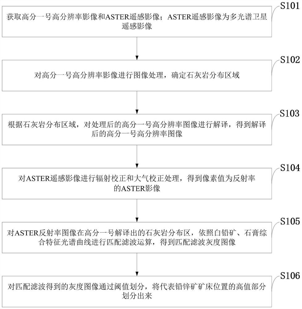
[0078] In order to make the object, technical solution and advantages of the present invention more clear, the present invention will be further described in detail below in conjunction with the examples. It should be understood that the specific embodiments described here are only used to explain the present invention, not to limit the present invention.

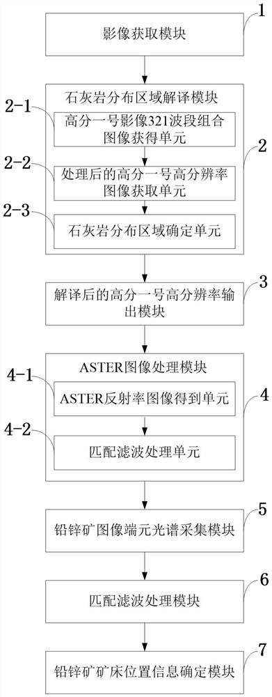
[0079] Aiming at the problems existing in the prior art, the present invention provides a method, system, equipment and application for surveying sedimentary secondary oxidized carbonatite-type lead-zinc deposits in areas with difficult traffic. The present invention will be described in detail below with reference to the accompanying drawings.

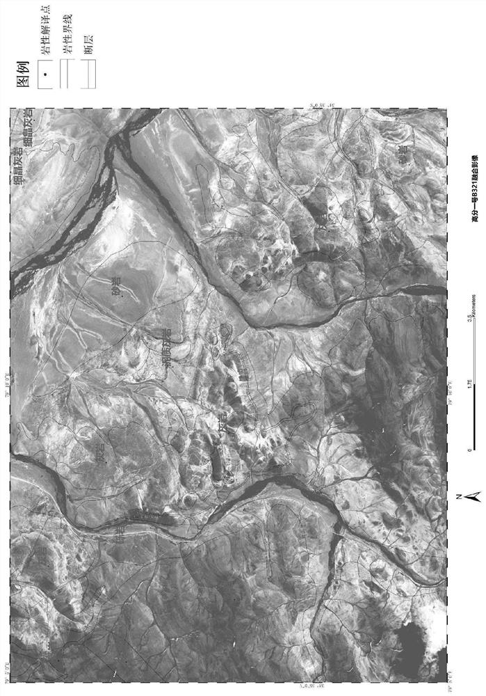
[0080] The development and maturity of satellite remote sensing technology has provided a good foundation for the development of this method. my country's existing Gaofen-1 satellite has the advantages of high geometric resolution, short revisit cycle, and free use. Although the ge...


PUM


Abstract

The invention belongs to the technical field of remote sensing identification of mineral resources, and discloses a traffic difficulty area sedimentary carbonate lead-zinc ore survey method and system, equipment and application. The method comprises the steps: acquiring a high-resolution image and a remote sensing image, wherein the remote sensing image is a multispectral satellite remote sensingimage; performing image processing on the high-resolution image, and determining a limestone distribution area; interpreting the processed high-resolution image according to the limestone distributionarea to obtain an interpreted high-resolution image; performing radiation correction and atmospheric correction processing on the remote sensing image to obtain a remote sensing image of which the pixel value is reflectivity; performing matched filtering operation on the remote sensing image reflectivity image in the interpreted limestone distribution area to obtain a matched filtering grayscaleimage; performing threshold division on the grayscale image, and dividing a high-value part representing the position of a lead-zinc ore deposit; according to the method, the secondary oxidized carbonatite type lead-zinc deposit can be efficiently, quickly and accurately identified.

Description

technical field [0001] The invention belongs to the technical field of remote sensing identification of mineral resources, and in particular relates to a survey method, system, equipment and application of sedimentary secondary oxidized carbonatite-type lead-zinc deposits in areas with difficult traffic. Background technique [0002] Lead-zinc ore is a major non-ferrous metal mineral. The distribution of lead-zinc mines is widespread but uneven, with more lean mines and less rich mines. Carbonate-type lead-zinc deposit is a kind of lead-zinc deposit with carbonate rock (limestone) as the host rock, and it is one of the important industrial types of lead-zinc deposit. Lead and zinc are widely used in electrical industry, machinery industry, military industry, metallurgical industry, chemical industry, light industry and pharmaceutical industry. In addition, lead metal also has many uses in nuclear industry, petroleum industry and other departments. More than 80% of the wor...

Claims


Application Information

Patent Timeline
Patent Type & Authority Applications(China)
IPC IPC(8): G01V8/02G06F17/15
CPCG01V8/02G06F17/15
Inventor 杨敏任广利
Owner XI'AN UNIVERSITY OF ARCHITECTURE AND TECHNOLOGY
Why Eureka
Try Eureka