
Remote sensing image semantic segmentation method based on deep learning

A remote sensing image and semantic segmentation technology, applied in the field of remote sensing image semantic segmentation based on deep learning, can solve the problems of difficulty in acquiring small object features and insufficient segmentation accuracy, and achieve the effect of improving segmentation accuracy, improving segmentation effect, and enhancing segmentation ability.

Inactive Publication Date: 2021-03-12
ZHONGBEI UNIV
View PDF4 Cites 11 Cited by
  • Summary
  • Abstract
  • Description
  • Claims
  • Application Information

AI Technical Summary

Problems solved by technology

[0004] Aiming at the problems of difficulty in acquiring features of small objects and insufficient segmentation accuracy in the mainstream deep convolutional neural network semantic segmentation method, the present invention provides a remote sensing image semantic segmentation method based on deep learning

Method used


Image

  • Remote sensing image semantic segmentation method based on deep learning
  • Remote sensing image semantic segmentation method based on deep learning
  • Remote sensing image semantic segmentation method based on deep learning

Examples


Embodiment 1

[0039] A method for semantic segmentation of remote sensing images based on deep learning in the present invention performs semantic segmentation on high-precision images, and the specific steps are as follows:

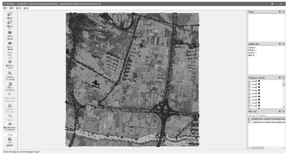
[0040] Step 1, dataset labeling: Label the collected high-precision remote sensing images with professional labelme software, and get the corresponding mask image after the labeling is completed. Process the obtained mask and convert it into an 8-bit grayscale image as a label for training the network.

[0041] Step 2, perform data enhancement on the labeling results obtained in step 1: randomly cut the original image of the remote sensing data and the marked mask, and the size of the picture obtained by each cutting is 256×256 pixels. Then rotate, flip, blur, Gaussian filter, bilateral filter and add white noise to each cut picture to obtain the enhanced data set. Such as figure 1 The data set annotation interface is shown in the figure.

[0042] Among them, befor...


PUM


Abstract

The invention discloses a remote sensing image semantic segmentation method based on deep learning, and belongs to the technical field of machine vision. Aiming at the problems of difficulty in obtaining features of small objects and insufficient segmentation precision of a semantic segmentation method of a mainstream deep convolutional neural network, the method comprises the following steps: improving a Deeplabv3 algorithm, improving a single up-sampling layer, and performing multi-layer up-sampling by utilizing residual errors obtained in a backbone network to ensure semantic integrity of an image in resolution; and meanwhile, modifying the expansion rate of four expansion convolution layers in the ASPP layer, so that the network has a better effect on small object segmentation. The result shows that the mIou and pixel accuracy of the improved Deeplabv3 semantic segmentation algorithm on a self-made data set reaches 94.92% and 98.01% respectively, which are improved by 3.77% and 2.40% respectively compared with the original algorithm, so that the improved Deeplabv3 semantic segmentation algorithm not only has higher accuracy, but also has better robustness for segmentation of various terrains; the method is suitable for a complex urban remote sensing image environment, and can be well applied to the fields of urban planning, agricultural planning, military war and the like.

Description

technical field [0001] The invention belongs to the technical field of machine vision, and in particular relates to a method for semantic segmentation of remote sensing images based on deep learning. Background technique [0002] With the continuous development of remote sensing technology, the semantic information contained in remote sensing images is becoming more and more abundant. Therefore, how to perform semantic segmentation on remote sensing images, extract important semantic information quickly and accurately, and carry out later application and development is a key issue. A very important research topic. Semantic segmentation of remote sensing images has a wide range of applications, involving urban planning, geological disaster prevention, military war simulation, etc. Especially in military war simulation, the semantic information segmented from remote sensing images plays an extremely important role in the rapid generation of real battlefield terrain and the ra...

Claims


Application Information

Patent Timeline
Patent Type & Authority Applications(China)
IPC IPC(8): G06T7/11G06T5/00G06T7/90G06T3/40G06K9/62G06N3/04G06N3/08
CPCG06T7/11G06T5/00G06T7/90G06T3/4007G06N3/08G06T2207/20021G06N3/045G06F18/214
Inventor 熊风光张鑫刘欢乐韩燮况立群
Owner ZHONGBEI UNIV
Learn More