Depth map obtaining method and system, unmanned aerial vehicle orthogram generation method and medium

A depth map, UAV technology, applied in image analysis, image data processing, computer parts and other directions, can solve the problem of inaccurate measurement, and achieve the effect of improving the matching accuracy, reducing the error, and unifying the local depth.

Active Publication Date: 2021-03-16
CHENGDU UNION BIG DATA TECH CO LTD
View PDF6 Cites 2 Cited by
  • Summary
  • Abstract
  • Description
  • Claims
  • Application Information

AI Technical Summary

Problems solved by technology

In the traditional MVS method, the farther the distance, the less accurate the depth measurement
At the same time, it is necessary to adapt to the situation where the depth changes sharply and gently, but this increases the situation where measurement errors are prone to occur in the 3D reconstruction of the UAV
In addition, common block matching algorithms are also prone to mis-match

Method used


Image

  • Depth map obtaining method and system, unmanned aerial vehicle orthogram generation method and medium
  • Depth map obtaining method and system, unmanned aerial vehicle orthogram generation method and medium
  • Depth map obtaining method and system, unmanned aerial vehicle orthogram generation method and medium

Examples


Embodiment 1

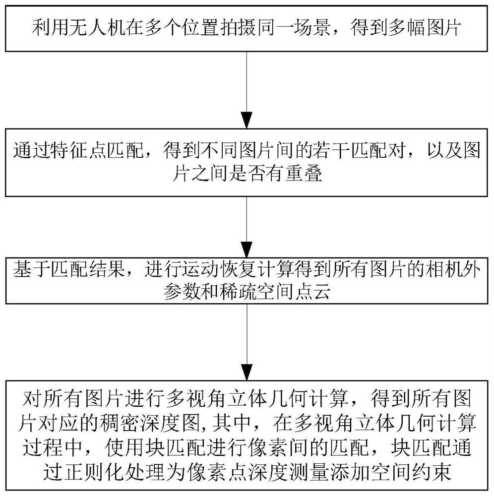
[0057] The present invention provides a depth map acquisition method, figure 1 It is a schematic flow diagram of the method for obtaining a depth map. This method includes:

[0058] Use drones to shoot the same scene in multiple locations and get multiple pictures;

[0059] Through feature point matching, several matching pairs between different pictures are obtained, and whether there is overlap between the pictures;

[0060] Based on the matching results, perform motion recovery calculations to obtain the extra-camera parameters and sparse spatial point clouds of all pictures;

[0061] Perform multi-view stereo geometry calculations on all pictures to obtain dense depth maps corresponding to all pictures;

[0062] Among them, in the process of multi-view stereo geometry calculation, block matching is used to match between pixels, and block matching adds spatial constraints to pixel depth measurement through regularization processing.

[0063] The invention performs spatia...

Embodiment 2

[0113] Embodiment 2 of the present invention provides a depth map acquisition system, Figure 4 Obtain a schematic diagram of the composition of the system for the depth map, the system includes:

[0114] The picture acquisition unit is used to use the unmanned aerial vehicle to shoot the same scene at multiple positions to obtain multiple pictures;

[0115] A feature point matching unit is used to obtain several matching pairs between different pictures through feature point matching, and whether there is overlap between the pictures;

[0116] The motion recovery calculation unit is used to perform motion recovery calculations based on the matching results to obtain the extra-camera parameters and sparse space point clouds of all pictures;

[0117] The multi-view stereo geometry calculation unit is used to perform multi-view stereo geometry calculations on all pictures to obtain dense depth maps corresponding to all pictures;

[0118] Among them, in the multi-view stereo ge...

Embodiment 3

[0127] Embodiment 3 of the present invention provides a method for generating an orthophoto map of an unmanned aerial vehicle, wherein the method includes:

[0128] Use drones to shoot a scene from multiple angles to get multiple pictures;

[0129] Preprocess all images;

[0130] Extract feature points from the preprocessed image, match any two images, determine image pairs with overlapping areas, and obtain feature point matching results;

[0131] Perform motion recovery calculation based on the feature point matching results, and obtain the camera parameters of each picture and the coordinates of the spatial points corresponding to the matching feature points;

[0132] Based on the UAV camera parameters and the coordinates of the spatial points corresponding to the matching feature points, the multi-view stereo geometry calculation is performed to obtain the dense depth map of all pictures; in the process of multi-view stereo geometry calculation, epipolar search and block ...


PUM


Abstract

The invention discloses a depth map obtaining method and system, an unmanned aerial vehicle orthogram generation method and a medium, and relates to the field of unmanned aerial vehicle remote sensingimage processing, and the method comprises the steps of photographing the same scene at a plurality of positions through an unmanned aerial vehicle, and obtaining a plurality of pictures; through feature point matching, obtaining a plurality of matching pairs among different pictures, and judging whether the pictures are overlapped or not; based on a matching result, performing motion recovery calculation to obtain camera external parameters and sparse space point clouds of all pictures; performing multi-view solid geometry calculation on all the pictures to obtain dense depth maps corresponding to all the pictures; according to the invention, block matching is used for matching between pixels, and spatial constraints are added to pixel point depth measurement through regularization processing of the block matching; according to the invention, the error of depth measurement can be reduced through space regularization constraint, the local depth tends to be uniform, the method is moresuitable for the situation that the depth change amplitude in a high-altitude unmanned aerial vehicle three-dimensional reconstruction scene is not large, and meanwhile the depth of some block matching failure points can be reasonably recovered.

Description

technical field [0001] The invention relates to the field of UAV remote sensing image processing, in particular, to a method and system for obtaining a depth map, a method and a medium for generating an UAV orthophoto map. Background technique [0002] At present, 3D reconstruction technology is becoming more and more mature, and the integration with deep learning is also in full swing. The most important technologies in 3D reconstruction are matching point pairs, SfM (motion recovery) and MVS (multi-view stereo vision). The main function of matching point pairs is to match pixels with the same name, and the mainstream methods are mainly feature point method and optical flow method. SfM estimates the camera parameters from the results of matching point pairs, and optimizes the camera parameters globally to obtain a smaller error globally. MVS uses the estimated camera parameters to measure the depth of the pixels in the image to obtain a dense or semi-dense point cloud. W...

Claims


Application Information

Patent Timeline
Patent Type & Authority Applications(China)
IPC IPC(8): G06T17/00G06T7/593G06K9/46G06K9/62
CPCG06T17/00G06T7/596G06V10/40G06F18/22Y02T10/40
Inventor 不公告发明人
Owner CHENGDU UNION BIG DATA TECH CO LTD
Why Eureka
Try Eureka