
Permeable ground area rate estimation method, device and equipment and storage medium

An area ratio, ground technology, applied in computing, computer parts, image data processing, etc., can solve the problems of unfavorable small area research range, large slice space range, low accuracy, etc., to achieve high data resolution and data acquisition. Flexible means and accurate extraction results

Pending Publication Date: 2021-03-30
广州市城市规划设计有限公司
View PDF0 Cites 1 Cited by
  • Summary
  • Abstract
  • Description
  • Claims
  • Application Information

AI Technical Summary

Problems solved by technology

The shortcomings of the existing achievements are as follows: ① Low accuracy, the spatial pixel resolution of the multispectral satellite remote sensing image data that can be quickly obtained on the Internet is not high (mostly 19.5 meters, 30 meters), and the accurate delineation of permeable ground materials Poor accuracy; ② Poor mobility. When multispectral satellite remote sensing image data service providers provide free data services, they often use slice services. The spatial range of slices is large (generally thousands of square kilometers) and relatively fixed, which is not conducive to flexible planning Determine the research scope of the small area

Method used


Image

  • Permeable ground area rate estimation method, device and equipment and storage medium
  • Permeable ground area rate estimation method, device and equipment and storage medium
  • Permeable ground area rate estimation method, device and equipment and storage medium

Examples


Embodiment Construction

[0083] In order to have a clearer understanding of the technical features, purpose, and effects of the present invention, the specific implementation manners of the present invention will be further described in detail below in conjunction with the accompanying drawings and embodiments. The following examples are only used to illustrate the present invention, but are not used to limit the protection scope of the present invention. Based on the embodiments of the present invention, other embodiments obtained by those skilled in the art without making creative efforts shall all belong to the protection scope of the present invention.

[0084] In the description of the present invention, it should be understood that the numbers themselves, such as "first", "second", etc., are only used to distinguish the described objects, and have no order or technical meaning, and cannot be interpreted as stipulating Or hint at the importance of the object being described.

[0085] In order to...


PUM


Abstract

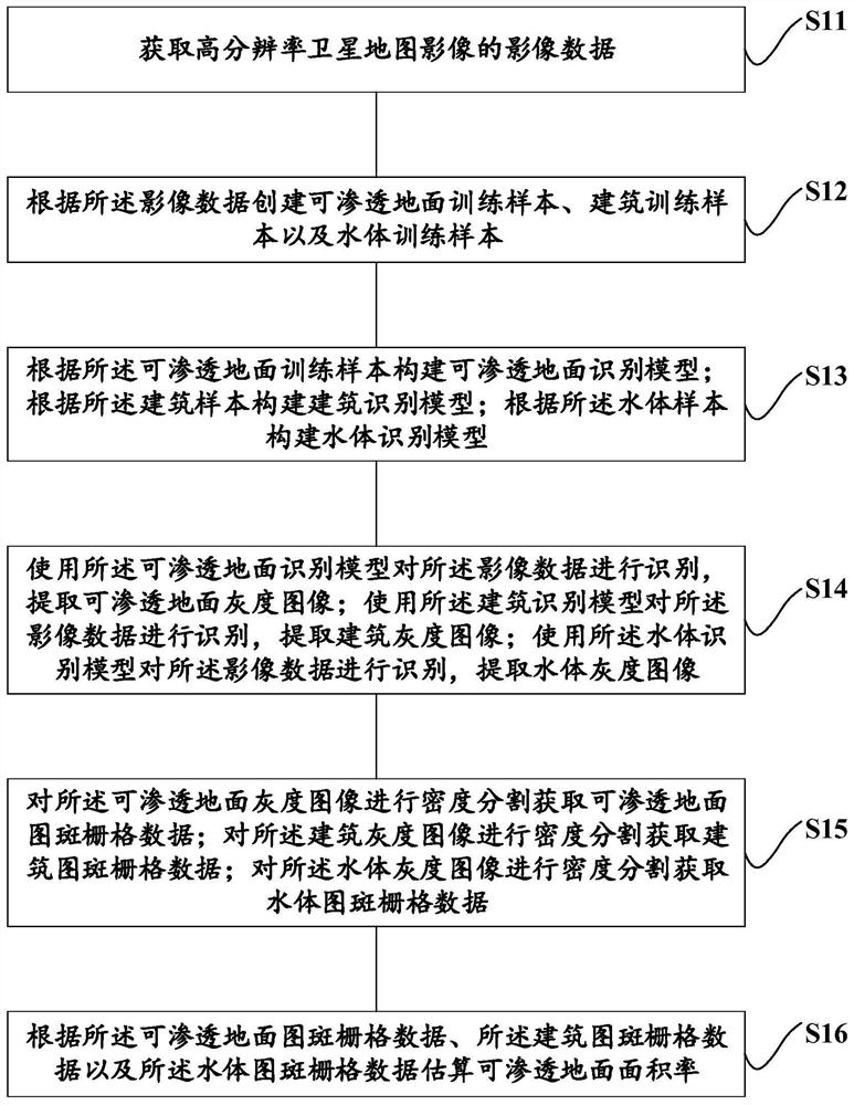
The invention relates to the technical field of geographic information processing, discloses a permeable ground area rate estimation method, device and equipment and a storage medium, and can improvethe permeable ground area rate estimation efficiency and accuracy. The method comprises the following steps: acquiring influence data of a high-resolution satellite image through a map downloading area; based on the image data, creating a training sample of an identification element (permeable ground, building and water body) required by permeable ground area rate estimation; constructing a deep learning model based on the training sample, performing training, then classifying the overall image data according to the trained model, and extracting a gray scale image of an element required to beidentified for permeable ground area rate estimation; determining a segmentation threshold, and performing density segmentation on the grayscale image to obtain pattern spot raster data of the targetelement; estimating the proportion data of the target elements according to the raster data of the target elements, and estimating the permeable ground area rate.

Description

technical field [0001] The present invention relates to the technical field of geographic information processing, in particular to a method, device, equipment and storage medium for estimating the area ratio of permeable ground. Background technique [0002] The area and distribution of urban permeable ground are of great significance for understanding the development status of sponge cities and evaluating the quality of urban environment. Relevant policy documents and technical standards from the national, provincial to municipal levels have put forward specific requirements for the proportion of urban permeable ground area. This indicator is also an important indicator for evaluating the construction of sponge cities. [0003] At present, there are very few research results on the estimation of urban permeable ground area. The only results mainly focus on using multispectral satellite remote sensing image data to segment objects and identify completely impermeable ground (...

Claims


Application Information

Patent Timeline
IPC IPC(8): G06K9/00G06K9/32G06K9/62G06Q50/26G06T7/136G06T7/62
CPCG06T7/136G06T7/62G06Q50/26G06T2207/20081G06T2207/10032G06T2207/30188G06T2207/30184G06V20/176G06V20/13G06V20/188G06V10/25G06F18/214
Inventor 胡珊岳晓琴李骁周晓穗于萍萍李飘燕李浚宏彭晋兴胡均
Owner 广州市城市规划设计有限公司
Learn More