Unmanned aerial vehicle dotting method, device and equipment and storage medium

A technology of drones and target points, applied in image analysis, image enhancement, instruments, etc., can solve the problem of low efficiency of target point management, and achieve the effect of helping job planning and improving experience.

Pending Publication Date: 2021-04-09
GUANGZHOU XAIRCRAFT TECH CO LTD
View PDF5 Cites 7 Cited by
  • Summary
  • Abstract
  • Description
  • Claims
  • Application Information

AI Technical Summary

Problems solved by technology

[0005] The purpose of this application is to provide a UAV marking method, device, equipment and st

Method used


Image

  • Unmanned aerial vehicle dotting method, device and equipment and storage medium
  • Unmanned aerial vehicle dotting method, device and equipment and storage medium
  • Unmanned aerial vehicle dotting method, device and equipment and storage medium

Examples


Embodiment Construction

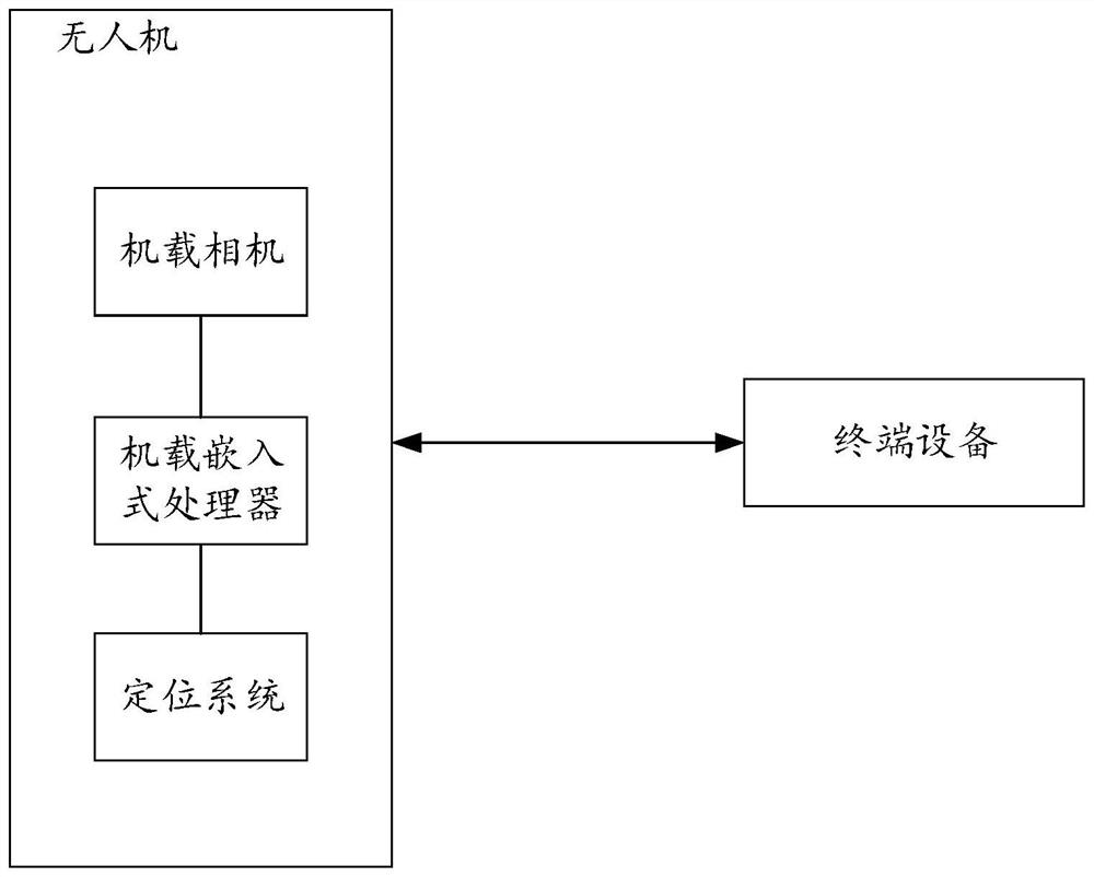
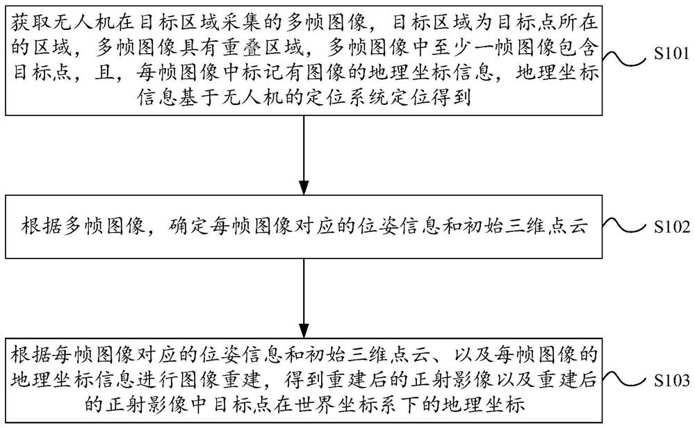
[0067] In order to make the purpose, technical solutions and advantages of the embodiments of the present application clearer, the technical solutions in the embodiments of the present application will be clearly and completely described below in conjunction with the drawings in the embodiments of the present application. It should be understood that the appended The figures are only for the purpose of illustration and description, and are not used to limit the protection scope of the present application. Additionally, it should be understood that the schematic drawings are not drawn to scale. The flowcharts used in this application illustrate operations implemented in accordance with some embodiments of the application. It should be understood that the operations of the flowcharts may be performed out of order, and steps that have no logical context may be performed in reverse order or concurrently. In addition, those skilled in the art may add one or more other operations t...


PUM


Abstract

The invention provides an unmanned aerial vehicle dotting method, device and equipment and a storage medium, and relates to the technical field of unmanned aerial vehicle measurement. The method comprises the following steps: collecting multiple frames of images by an unmanned aerial vehicle in a target area, wherein the target area is the area where a target point is located, the multiple frames of images have an overlapping area, at least one frame of image in the multiple frames of images comprises the target point, geographical coordinate information of the image is marked in each frame of image, and the geographical coordinate information is obtained based on positioning of a positioning system of the unmanned aerial vehicle; determining pose information and initial three-dimensional point cloud corresponding to each frame of image according to the multiple frames of images; and performing image reconstruction according to the pose information and the initial three-dimensional point cloud corresponding to each frame of image and the geographical coordinate information of each frame of image to obtain a reconstructed orthoimage and geographical coordinates of a target point in the reconstructed orthoimage in a world coordinate system. Through the method, the image reconstruction speed is improved to a certain extent, so that the target point dotting efficiency is effectively improved.

Description

technical field [0001] The present application relates to the technical field of UAV measurement, and in particular, to a method, device, equipment and storage medium for UAV marking. Background technique [0002] Target point marking is to obtain the corresponding real-world geographic coordinate data of the target point through a device equipped with GPS (Global Positioning System, Global Positioning System), and usually measure the latitude, longitude and altitude of the target point. The geographic coordinates of the target point can be accurately obtained through dot marking, so as to guide the ground operations. [0003] In the prior art, when dotting the ground target points, it is necessary to go to the ground control points to collect GPS coordinates, take pictures of the target points through the aircraft carrying the camera, and match the ground control points with the photographs taken to complete the three-dimensional scene reconstruction. Dot the target point ...

Claims


Application Information

Patent Timeline
IPC IPC(8): G06T7/73G06T5/50G06T17/05G06T17/20G06T15/04
CPCG06T7/73G06T5/50G06T17/05G06T17/205G06T15/04G06T2207/10028G06T2207/20221G06T2207/30204G06T2207/30244
Inventor 邓杭池鹏可
Owner GUANGZHOU XAIRCRAFT TECH CO LTD
Why Eureka
Try Eureka