Ship target track association method for stationary orbit staring satellite remote sensing image

A geostationary orbit, target track technology, applied in the field of satellite remote sensing, can solve problems such as difficulty in adapting to target track association, short continuous observation time, and few remote sensing image sequence sampling points.

Active Publication Date: 2021-04-20
NAVAL AVIATION UNIV +1
View PDF8 Cites 3 Cited by
  • Summary
  • Abstract
  • Description
  • Claims
  • Application Information

AI Technical Summary

Problems solved by technology

[0004] The existing technology requires the data to have a high sampling rate or a high spatial resolution of the image. However, the remote sensing image sequence obtained by staring satellites in geostationary orbit has the characteristics of few sampling points, low spatial resolution, and short continuous obser

Method used


Image

  • Ship target track association method for stationary orbit staring satellite remote sensing image
  • Ship target track association method for stationary orbit staring satellite remote sensing image
  • Ship target track association method for stationary orbit staring satellite remote sensing image

Examples


Embodiment Construction

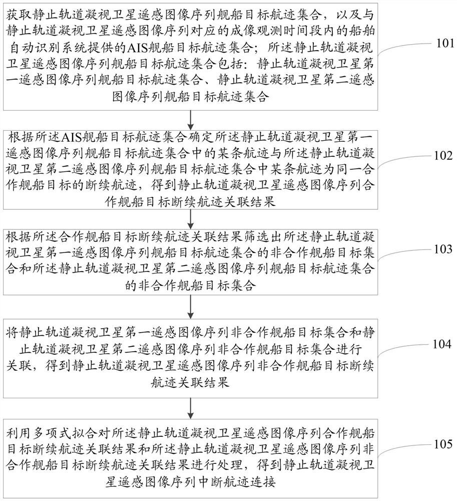
[0090] The following will clearly and completely describe the technical solutions in the embodiments of the present invention with reference to the accompanying drawings in the embodiments of the present invention. Obviously, the described embodiments are only some, not all, embodiments of the present invention. Based on the embodiments of the present invention, all other embodiments obtained by persons of ordinary skill in the art without making creative efforts belong to the protection scope of the present invention.

[0091] The terms "first", "second", "third", etc. (if any) in the description and claims of the present invention and the above drawings are used to distinguish similar objects and not necessarily to describe a specific order or sequentially. It should be understood that the items so described are interchangeable under appropriate circumstances. Furthermore, the terms "comprising" and "having", as well as any variations thereof, are intended to cover a non-ex...


PUM


Abstract

The invention relates to a ship target track association method for a stationary orbit staring satellite remote sensing image, belongs to the technical field of satellite remote sensing, introduces ship automatic identification system information, firstly realizes association of cooperative ship targets, effectively reduces the number of association matching combinations, and then is divided into two association stages to associate non-cooperative targets. The number of matching combinations in the association algorithm is reduced, the ship target track association speed is improved, the influence of medium-low resolution and low frame rate conditions on interrupted track association of the ship target is overcome, association complexity is reduced, association accuracy is improved, finally, the associated interrupted tracks are connected, and ship target track association efficiency is improved; and integrity of ship target situation display is improved.

Description

technical field [0001] The invention relates to the technical field of satellite remote sensing, in particular to a method for associating track of a ship target in a geostationary orbit staring satellite remote sensing image. Background technique [0002] The traditional target track correlation method is aimed at two types of data: one is radar and electronic reconnaissance data, which is characterized by a high data sampling rate and is mainly realized based on target motion characteristics; the other is multi-camera video data , this type of data is characterized by high image spatial resolution, which is mainly realized based on the target image features. [0003] Geostationary orbit staring satellites can stay over a fixed area for a long time, and can quickly adjust the imaging surveillance area as needed. Each observation can obtain the track of the ship target in the relevant sea area. By associating the track of the ship target at different imaging moments , that ...

Claims


Application Information

Patent Timeline
IPC IPC(8): G06K9/00G06K9/62G06F17/16G06F17/18
Inventor 刘瑜李刚姚力波孙顺林迅丁自然谭大宁
Owner NAVAL AVIATION UNIV
Why Eureka
Try Eureka