Tide gauge station vertical reference detection method using GNSS buoys
A detection method and a buoy technology, which are applied in the direction of measuring devices, radio wave measurement systems, satellite radio beacon positioning systems, etc., can solve the problems that cannot take into account the displacement error of the datum point of the tide gauge station, the results of leveling continuous measurement cannot be unified, and the tide gauge The station lacks the national 85 elevation system and other issues
- Summary
- Abstract
- Description
- Claims
- Application Information
AI Technical Summary
Problems solved by technology
Method used
Image
Examples
Embodiment 1
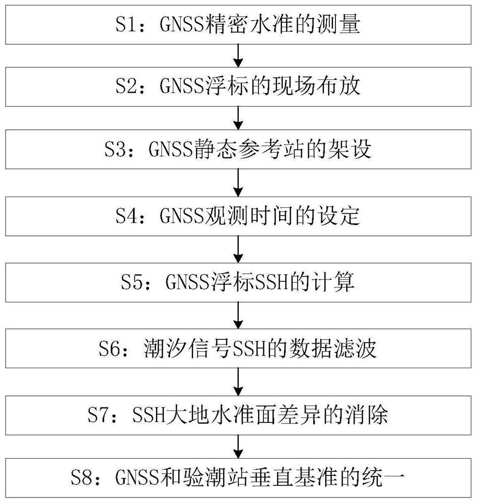
[0033] Such as Figure 1 to Figure 3 As shown, the vertical reference detection method of the tide gauge station utilizing the GNSS buoy described in the present invention comprises the following steps:
[0034] S1: GNSS precision level measurement: determine the height of the GNSS buoy antenna through precise measurement in the laboratory, and determine the height h1 from the phase center of the GNSS buoy antenna to the still water surface;
[0035] S2: On-site deployment of GNSS buoys: including the following small steps:
[0036] S21: GNSS buoys are deployed in the open sea near the marine station;
[0037] S22: The GNSS buoy is connected through a nearby fixed floating ball, so that its horizontal position does not change greatly;
[0038] S23: the sampling frequency of the GNSS buoy is set to 1 Hz;
[0039] S3: GNSS static reference station erection: GNSS static reference station is erected in the land area of the marine station for differential post-processing of GN...
Embodiment 2
[0056] Take the sea experiment with unified measurement datum at a marine station along the coast of Shandong as an example.
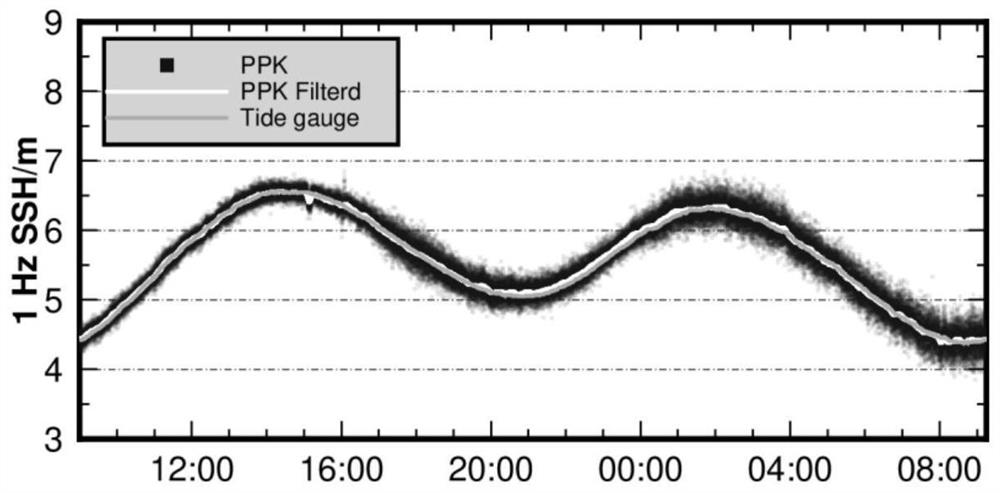
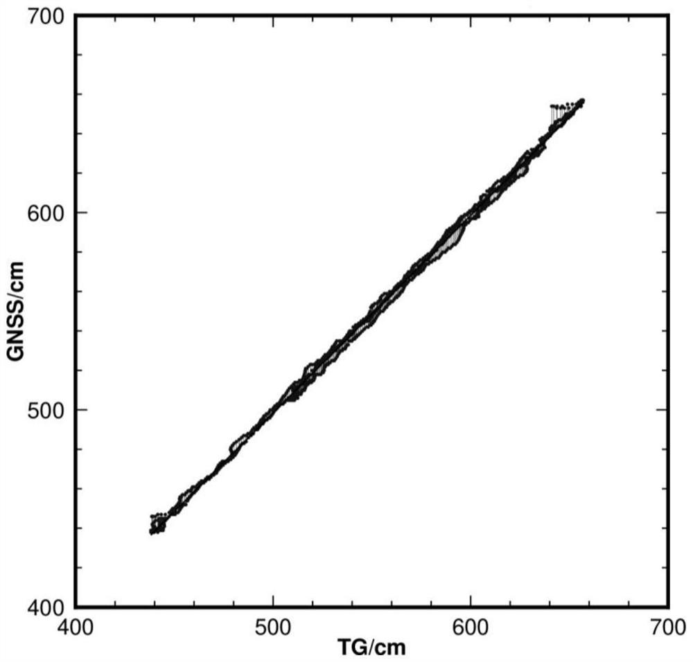
[0057] Assume that a GNSS altimetry buoy is deployed in the open sea area outside the ocean station to observe data for more than 1 day, and the SSH of the GNSS buoy is obtained by the PPK method, and then the geoid difference is corrected, the data is filtered, and the filtered GNSS sea surface By making difference between the height data and the data of the tide gauge station, the difference between the elevation datum of the tide gauge station and the elevation datum of the WGS-84 reference ellipsoid is 54cm, and the slope obtained by the regression analysis is equal to 1.0, where figure 2 For the unified tide gauge and GNSS sea level height, image 3 is the regression analysis result of the unified GNSS and tide gauge sea surface height.
[0058] It should be noted that the unification of the datum of the ocean station tide gauge system is an imp...
PUM
 Abstract
Description
Claims
Application Information
 - R&D
- Intellectual Property
- Life Sciences
- Materials
- Tech Scout
- Unparalleled Data Quality
- Higher Quality Content
- 60% Fewer Hallucinations
Browse by: Latest US Patents, China's latest patents, Technical Efficacy Thesaurus, Application Domain, Technology Topic, Popular Technical Reports.
© 2025 PatSnap. All rights reserved.Legal|Privacy policy|Modern Slavery Act Transparency Statement|Sitemap|About US| Contact US: help@patsnap.com


