Underwater three-dimensional map construction method based on sonar and visual image splicing

A visual image and three-dimensional map technology, applied in image analysis, image enhancement, graphics and image conversion, etc., can solve problems such as inability to build high-precision three-dimensional maps, small visual range, limited camera viewing distance, etc., to improve the visualization effect and accuracy, improve accuracy and stability, and overcome the serious effect of imaging edge distortion

Active Publication Date: 2021-04-30
YANSHAN UNIV
View PDF15 Cites 4 Cited by
  • Summary
  • Abstract
  • Description
  • Claims
  • Application Information

AI Technical Summary

Problems solved by technology

This solution only uses cameras to build underwater maps. In turbid water bodies, the camera has a limited ...

Method used


Image

  • Underwater three-dimensional map construction method based on sonar and visual image splicing
  • Underwater three-dimensional map construction method based on sonar and visual image splicing
  • Underwater three-dimensional map construction method based on sonar and visual image splicing

Examples


Embodiment Construction

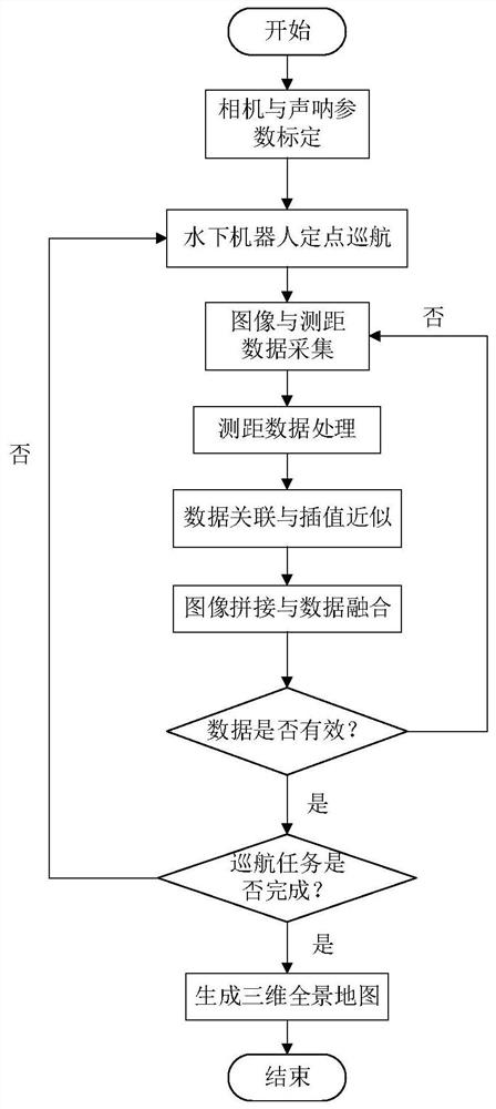
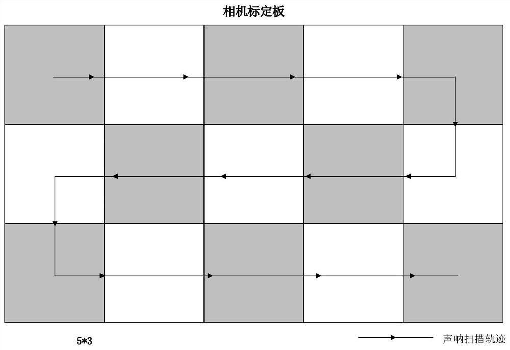
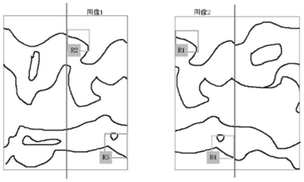
[0045] In order to enable those skilled in the art to better understand the solutions of the present invention, the following will clearly and completely describe the technical solutions in the embodiments of the present invention in conjunction with the drawings in the embodiments of the present invention. Obviously, the described embodiments are only It is an embodiment of a part of the present invention, but not all embodiments. Based on the embodiments of the present invention, all other embodiments obtained by persons of ordinary skill in the art without making creative efforts shall fall within the protection scope of the present invention.

[0046] It should be noted that the terms "first" and "second" in the description and claims of the present invention and the above drawings are used to distinguish similar objects, but not necessarily used to describe a specific sequence or sequence. It is to be understood that the data so used are interchangeable under appropriate ...


PUM


Abstract

The invention provides an underwater three-dimensional map construction method based on sonar and visual image splicing. The underwater three-dimensional map construction method comprises the steps of adopting an underwater robot carrying a mechanical scanning ranging sonar and a monocular camera for conducting visual image and sonar ranging data collection on an underwater environment at the same time; associating the sonar ranging data with the visual imaging data, performing dimension expansion on each frame of image, and adding the sonar ranging data to construct a three-dimensional map on the basis of the two-dimensional topographic image; carrying out multi-frame image expansion splicing by adopting an image splicing algorithm based on dot-line features and base on a local homography matrix model of grids to realize three-dimensional panoramic map synthesis. According to the method, multiple sensors are adopted to construct the underwater map, the complementarity is high, the problem that edge distortion is serious when a wide-angle camera is used is solved, and the three-dimensional panoramic map with the high visualization effect and accuracy is constructed.

Description

technical field [0001] The invention belongs to the technical field of underwater robots, in particular to an underwater three-dimensional map construction method based on sonar and visual image splicing. Background technique [0002] As marine resources are more and more needed by humans, the demand for marine development is increasing. In many vast sea areas and complex underwater environments, humans cannot reach them. It is necessary to rely on underwater robots to complete the detection and operation tasks of the underwater environment. . Due to the complexity of the underwater environment, the application of radar and laser sensors in water is greatly limited. Electromagnetic wave signals will rapidly attenuate in the underwater environment, making effective detection impossible. Visual imaging plays an important role in underwater environment detection and can replace humans to observe and record underwater terrain. Sound waves can be transmitted, observed and measur...

Claims


Application Information

Patent Timeline
IPC IPC(8): G06T17/05G01S15/86G01S15/89G06T3/40G06T7/80
CPCG06T17/05G06T3/4038G06T7/80G01S15/86G01S15/89G06T2207/30184
Inventor 闫敬尤康林杨晛罗小元
Owner YANSHAN UNIV
Why Eureka
Try Eureka