Environment modeling and path planning method based on multi-sensor fusion

A technology of multi-sensor fusion and path planning, applied in instruments, road network navigators, electromagnetic wave re-radiation, etc., can solve the problem of high error rate of unmanned vehicles, increase positioning accuracy, narrow search range, and reduce search time Effect

Active Publication Date: 2021-05-07
NORTHWESTERN POLYTECHNICAL UNIV
View PDF8 Cites 5 Cited by
  • Summary
  • Abstract
  • Description
  • Claims
  • Application Information

AI Technical Summary

Problems solved by technology

Different from the structured urban environment, the wild environment has the characteristics of undulating ground, various obstacles, and no road sign prompts, which lead to a high error rate in the

Method used


Image

  • Environment modeling and path planning method based on multi-sensor fusion
  • Environment modeling and path planning method based on multi-sensor fusion
  • Environment modeling and path planning method based on multi-sensor fusion

Examples


Embodiment Construction

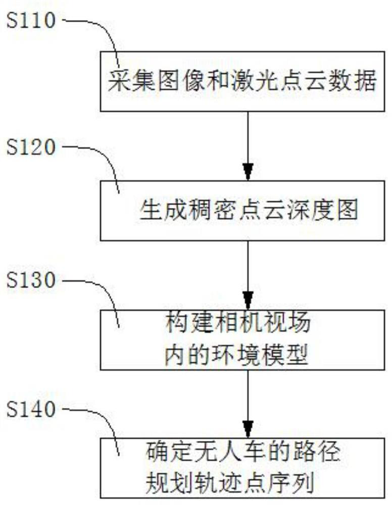
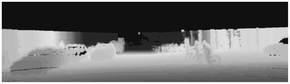
[0040] The present invention will be described in detail below in conjunction with the accompanying drawings and specific embodiments.

[0041] In the current research, the path planning for unmanned vehicles is mostly based on simple or globally known environments, and the schemes in complex field environments are relatively blank. Unmanned vehicles can make autonomous decisions and avoid obstacles without a good perception system. The single-sensor sensing environment is only applicable to a specific environment and has great limitations.

[0042] Therefore, the present invention proposes a multi-sensor fusion environment modeling algorithm and a path planning method under multi-constraint optimization on the basis of researching the autonomous perception and avoidance technology of unmanned vehicles. And the path planning technology based on mathematical models enables autonomous unmanned vehicles to make online decisions and drive safely in complex field environments. Th...


PUM


Abstract

The invention discloses an environment modeling and path planning method based on multi-sensor fusion. The method comprises the following steps: acquiring an image and laser point cloud data in a camera field of view on an unmanned vehicle at the same time; generating a dense point cloud depth map according to the image and the laser point cloud data; taking coordinate values in the dense point cloud depth map as input, and combining a radial basis function neural network to construct an environment model in a camera view field; and determining a path planning track point sequence of the unmanned vehicle by taking the minimum height and gradient of the track point as a target and taking an environment feature vector threshold value and a single-step length as constraint conditions. The laser point cloud data and the image of the camera are fused to serve as input data of environment model construction, the position information of the obstacles can serve as input weights to be applied to environment modeling, the positioning accuracy of the field concave-convex obstacles in the environment model can be improved, and the search time is shortened.

Description

technical field [0001] The invention belongs to the technical field of autonomous perception and obstacle avoidance of unmanned systems, and in particular relates to an environment modeling and path planning method based on multi-sensor fusion. Background technique [0002] The rapid development of society and science has brought more extensive technical support to the research of intelligent systems. With the development of sensor and computer technology, the research on ground intelligent mobile unmanned platform continues to deepen, and the unmanned vehicle system is one of the typical representatives. Unmanned vehicles are often used to replace humans to perform dangerous, complex and repetitive tasks, such as reconnaissance, search and rescue, transportation, archaeological exploration, sample collection, military strike, etc. Wait. Research work on ground mobile unmanned vehicles is of extensive value for the development of future unmanned systems. [0003] Environm...

Claims


Application Information

Patent Timeline
IPC IPC(8): G01C21/34G01C21/28G01C11/00G01S17/86G01S17/89
CPCG01C21/3407G01C21/3446G01C21/28G01C11/00G01S17/86G01S17/89
Inventor 胡劲文赵春晖徐钊
Owner NORTHWESTERN POLYTECHNICAL UNIV
Why Eureka
Try Eureka