Existing railway line cross section measurement method based on airborne LiDAR point cloud

A measurement method and cross-sectional technology, applied to computer parts, instruments, scene recognition, etc., can solve problems such as low practicability, long time consumption, and heavy workload

Active Publication Date: 2021-05-18
CHINA RAILWAY ERYUAN ENG GRP CO LTD
View PDF9 Cites 4 Cited by
  • Summary
  • Abstract
  • Description
  • Claims
  • Application Information

AI Technical Summary

Problems solved by technology

This method has a high degree of automation, but when it is applied to the cross-section measurement of existing railway lines, it has insufficient accuracy, the characteristic positions such as rails are "drawn" or missing, manual classification is required, and the superposition process of DEM and DOM takes a long time. High performance requirements, poor applicability, etc.
[0008] To sum up, the current cross-section measurement of existing railway lines is mainly carried out in the field at night, which has a large workload, low efficiency and high operating costs.
However, the collection of cross-sections of existing railway lines in the office may require a large number of field measurement control points to ensure the measurement accuracy; or in order to pursue measurement efficiency, the characteristic data such as railway rails, ballast shoulders and ballast feet will be "spread" or missing. The measurement results are distorted; or to ensure the accuracy, the manual classification of point cloud data requires a huge workload (the current automatic classification algorithm for point cloud data cannot accurately and quickly classify the rails, ballast shoulders and ballast feet, etc. data, which need to be manually identified and classified), the applicability and practicability to the cross-section collection of existing railway lines are not strong

Method used


Image

  • Existing railway line cross section measurement method based on airborne LiDAR point cloud
  • Existing railway line cross section measurement method based on airborne LiDAR point cloud
  • Existing railway line cross section measurement method based on airborne LiDAR point cloud

Examples


Embodiment

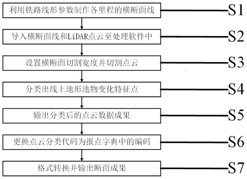
[0077] The existing railway cross-section measurement method based on airborne LiDAR point cloud in this embodiment includes the following implementation steps:

[0078] S1. Use the railway line position data, cross-section acquisition requirements and cross-section creation tools to make cross-section lines of specified lengths for each mileage;

[0079] The railway alignment data can be in ACSII text format or design file format such as DWG, DXF or DGN, and the data content includes intersection coordinates, curve radius, transition curve length, starting point mileage of the alignment and its coordinates and end point coordinates, etc.

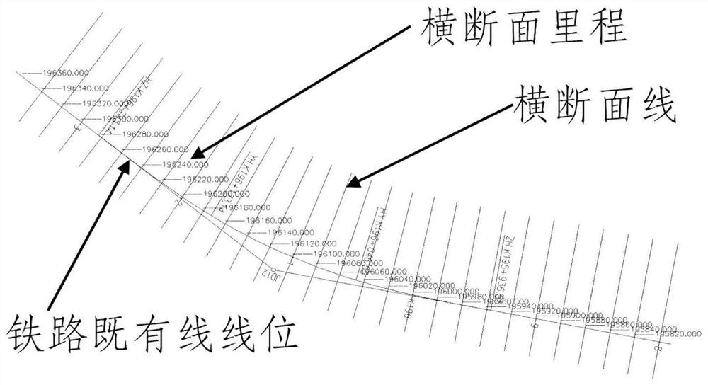
[0080] In the present embodiment, the described railway alignment data not only includes the DWG file of the railway alignment, but also includes the text file of the railway alignment data; the DWG file is used to display the overlay diagram of the railway alignment and the cross-section line, In order to check the accuracy of the cross-se...


PUM


Abstract

The invention relates to the field of reconstructed railway engineering measurement, and provides an existing railway line cross section measurement method based on airborne LiDAR point cloud, which aims at overcoming the defects of an existing railway line cross section measurement scheme in the prior art and is high in practicability, high in operation efficiency, low in operation difficulty and high in safety. The method comprises the following steps: S1, making cross section lines of each mileage according to railway line shape parameters; S2, importing the cross section line and the preprocessed airborne LiDAR point cloud data into point cloud processing software; S3, setting a cross section cutting width and cutting a point cloud; S4, classifying terrain feature change feature points on the line; S5, outputting a classified point cloud data result; S6, replacing the point cloud classification code with a code in the report point dictionary; and S7, performing format conversion and outputting a section result.

Description

technical field [0001] The invention relates to the field of railway engineering measurement for reconstruction, in particular to an airborne LiDAR point cloud-based method for measuring the cross-section of an existing railway line. Background technique [0002] With the progress of society and the development of science and technology, my country's railway construction has entered a new construction climax. Single-track to double-track railways, reconstruction of existing railways, construction of new railways, construction of high-speed railways, etc. make surveying and mapping work more fulfilling, especially cross-sectional surveying of existing railway lines. [0003] The cross-sectional diagram of the existing railway line is the basis for subgrade cross-section design, calculation of earth and stone volume and determination of subgrade filling and excavation boundaries in the construction process, and is one of the important work contents of railway reconstruction en...

Claims


Application Information

Patent Timeline
Patent Type & Authority Applications(China)
IPC IPC(8): G06K9/00G06K9/62
CPCG06V20/13G06V20/41G06F18/241Y02A90/10
Inventor 包建强梅熙刘志鹏周世明王义许懿娜刘竹均武鹏孔得辉罗枫
Owner CHINA RAILWAY ERYUAN ENG GRP CO LTD
Why Eureka
Try Eureka