Semantic mapping method based on track alignment

A technology of semantic mapping and trajectory, applied in the field of semantic mapping, can solve problems such as difficult extraction of semantic information and poor accuracy of visual SLAM mapping, achieve good flexibility and scalability, facilitate application, and solve inconsistent trajectory sequences Effect

Active Publication Date: 2021-05-25
杭州自适应科技有限公司
View PDF7 Cites 3 Cited by
  • Summary
  • Abstract
  • Description
  • Claims
  • Application Information

AI Technical Summary

Problems solved by technology

Although the current laser SLAM can generate high-precision environmental maps suitable for robot navigation with the help of laser radar sensors, it is not easy to extract semantic information in the environment because the laser radar sensor directly obtains point cloud information by relying on the laser time-of-flight method.
Visual SLAM uses the camera sensor to collect the image sequence of the environment for positioning and mapping. The environmental information obtained by this type of sensor data is more abundant and can be used to extract semantic information, but it is easily affected by environmental conditions. Therefore, the construction of visual SLAM Map accuracy tends to be worse than laser SLAM
[0003]Traditional SLAM can only construct geometric feature maps of the environment, and the tasks that robots can complete using such maps are still very limited, and semantic SLAM can further improve the robot's understanding of the environment. The degree of understanding, robots can also complete more complex tasks by using semantic maps. Therefore, it is of great significance to study the semantic mapping method of multi-sensor fusion in the field of semantic SLAM.

Method used


Image

  • Semantic mapping method based on track alignment
  • Semantic mapping method based on track alignment
  • Semantic mapping method based on track alignment

Examples


Embodiment Construction

[0047] The technical solutions in the embodiments of the present invention will be clearly and completely described below in conjunction with the embodiments of the present invention. Apparently, the described embodiments are only some of the embodiments of the present invention, not all of them. Based on the embodiments of the present invention, all other embodiments obtained by persons of ordinary skill in the art without making creative efforts belong to the protection scope of the present invention.

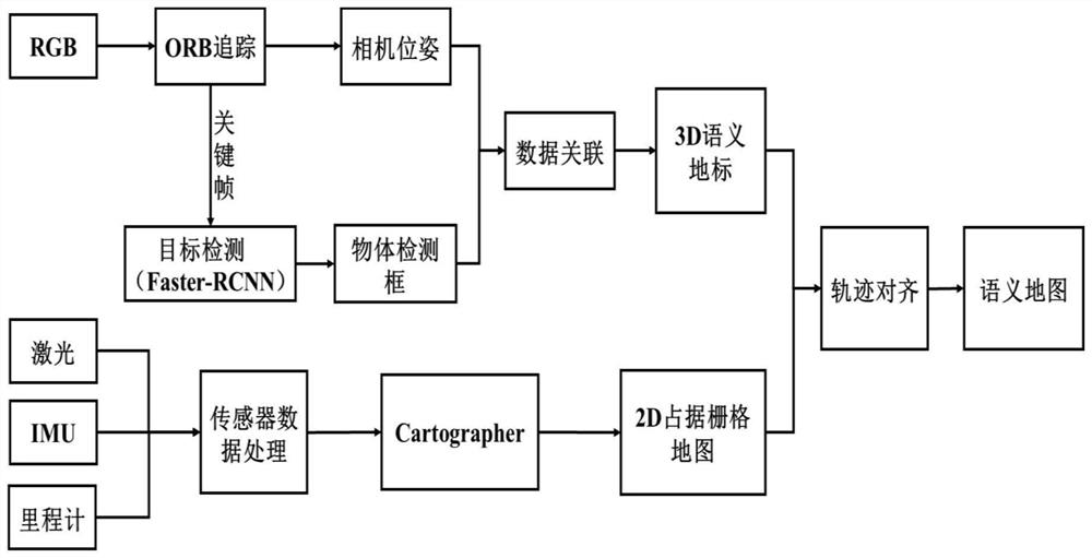
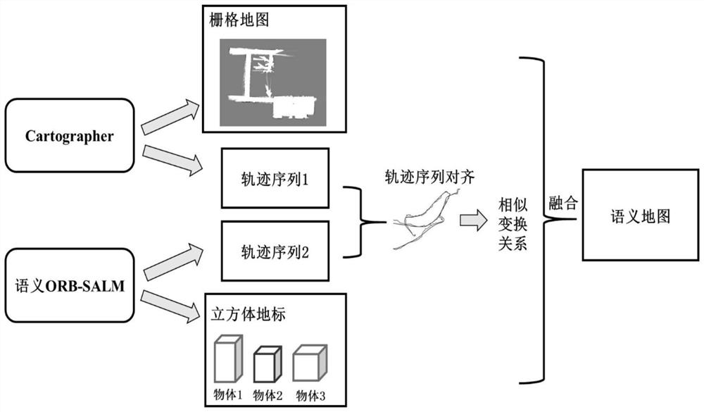
[0048] The embodiment of the present invention provides a semantic mapping method based on trajectory alignment. Aiming at the problem of traditional SLAM development content coupling, the present invention provides a SLAM development framework based on four levels. On this basis, a multi-sensor based Fusion semantic SLAM algorithm, such as figure 1 and figure 2 shown, including the following steps:

[0049] A1, use the monocular camera and the sweeping robot to scan and c...


PUM


Abstract

The invention discloses a semantic mapping method based on track alignment. The method comprises the following steps: S1, synchronously collecting RGB data, laser data, IMU data and odometer data along the same moving track; s2, through semantic ORB-SLAM, while ORB tracking is carried out by using RGB data, carrying out target detection on each frame of key frame image, constructing a triangulation relation, and extracting a 3D semantic landmark; S3, filtering the laser data by using downsampling operation, and performing calculation processing on IMU data and odometer data; s4, processing the laser data, the IMU data and the odometer data, and constructing a 2D grid map; and S5, solving a similarity transformation relationship between the ORB-SLAM and the track sequence by using the ORB-SLAM and the track sequence, and fusing the 3D semantic landmark and the 2D raster map to generate a semantic map. According to the scheme, the accurate grid map with the semantic landmark can be constructed.

Description

technical field [0001] The invention belongs to the field of semantic mapping, and relates to a semantic mapping method based on track alignment, which can be used to construct semantic maps of surrounding environments. Background technique [0002] SLAM (simultaneous localization and mapping, synchronous localization and mapping) technology can help the robot gradually build a map of the surrounding environment by using sensors to obtain information in an unfamiliar environment, and at the same time locate itself in the map according to changes in environmental information. Position, this technology can help mobile robots to achieve autonomous navigation tasks. Traditional SLAM technology is divided into two categories, but both are limited to the analysis of the geometric characteristics of the environment. The maps generated by traditional SLAM robots can only achieve some very basic functions such as avoiding obstacles and path planning. In recent years, the research on...

Claims


Application Information

Patent Timeline
IPC IPC(8): G01C21/32
CPCG01C21/32
Inventor 张亮朱光明汪火良蒋得志
Owner 杭州自适应科技有限公司
Why Eureka
Try Eureka