Surveying instrument support for geographic information science

A technology of geographic information and instrument support, which is applied in the field of geographic information science, can solve problems such as inconvenient operation and complicated operation process, and achieve the effects of easy replacement, simple fine-tuning operation, and convenient levelness.

Active Publication Date: 2021-05-28
广州盛鑫信息技术有限公司
View PDF12 Cites 5 Cited by
  • Summary
  • Abstract
  • Description
  • Claims
  • Application Information

AI Technical Summary

Problems solved by technology

[0003] When the existing surveying instrument bracket is in use, the surveying instrument bracket is roughly set directly above the control point, the leg support is inserted into the ground, and then the laser of the surveying instrument is turned on for point alignment, and the distance between the center of the surveying instrument bracket and the control point is checked by the laser, and the support The legs are pulled out from the soil for adjustment. This process requires multiple adjustments to the position of the supporting legs. The operation process is cumbersome and inconvenient to operate

Method used


Image

  • Surveying instrument support for geographic information science
  • Surveying instrument support for geographic information science
  • Surveying instrument support for geographic information science

Examples


Embodiment 1

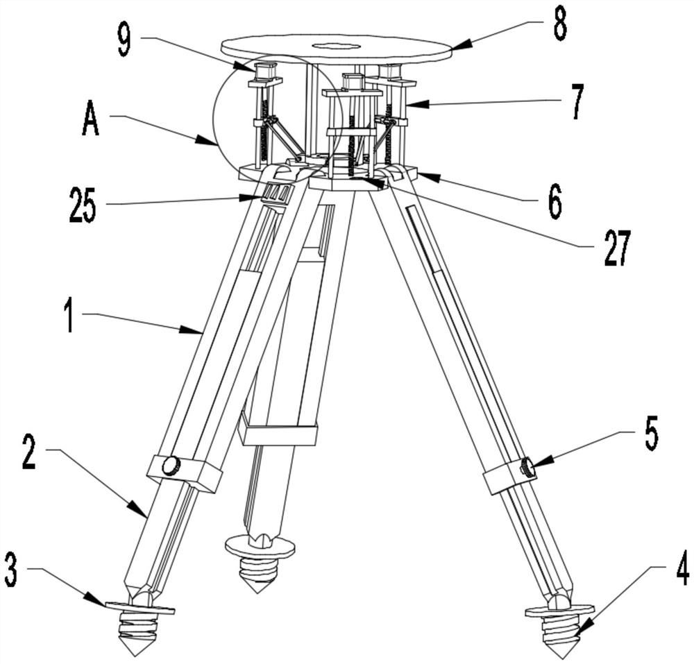
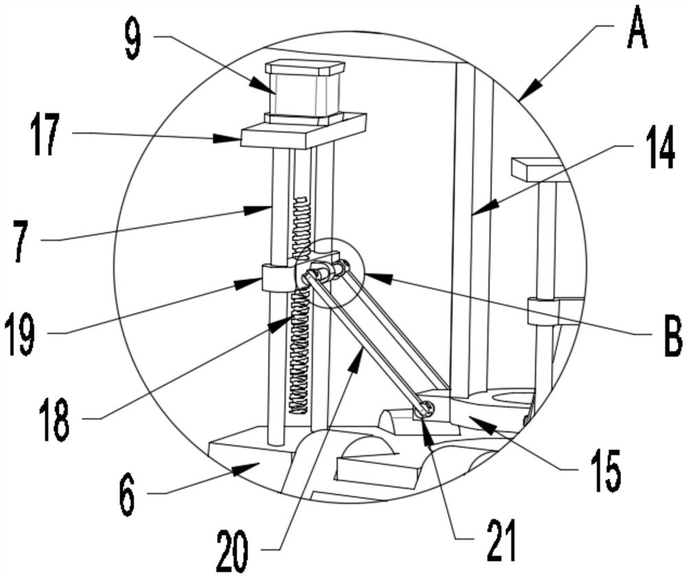
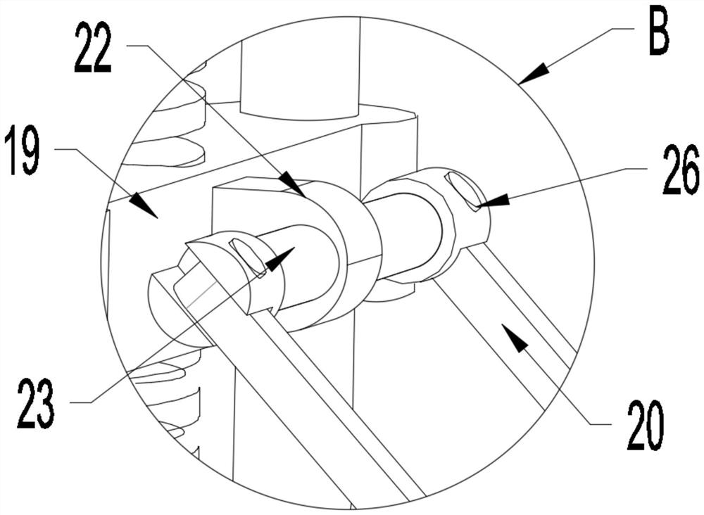
[0029] see Figure 1-6 , in an embodiment of the present invention, a geographic information science surveying and mapping instrument bracket includes a support plate 6, and three support rods 1 are uniformly installed on the support plate 6, and the three support rods 1 are all hinged to the support plate 6, The inside of the support rod 1 is provided with two guide blocks 12, the bottom of the support rod 1 is equipped with a fixed sleeve 10, the fixed sleeve 10 is provided with a fixing screw 11, and a telescopic rod 2 is installed in the support rod 1, Both sides of the telescopic rod 2 are provided with guide grooves 13, the guide grooves 13 are slidably connected with the guide block 12, the telescopic rod 2 slides in the support rod 1, and the bottom of the telescopic rod 2 is equipped with a fixing nail 4, so that The support plate 6 is provided with three adjustment mechanisms, the adjustment mechanism includes a guide shaft 7 arranged on the support plate 6, the top ...

Embodiment 2

[0031] see figure 1 The difference between the embodiment of the present invention and embodiment 1 is that a control box 25 is installed on the support rod 1, and the control box 25 is electrically connected with the servo motor 9, and the three servo motors 9 are controlled by the control box 25. start and reverse.

[0032] The working principle of the present invention is:

[0033]When in use, pull out the telescopic rod 2 from the support rod 1 to a suitable length, turn the fixed knob 5 to drive the fixed screw 11 to rotate, and the fixed screw 11 will be in close contact with the telescopic rod 2 to limit the sliding of the telescopic rod 2, and place the bracket roughly to the control position. Point the center, use the pedal 3 to push the fixing nail 4 deep into the soil, observe the level 27 to check the level of the support, turn the fixed knob 5 to adjust the matching length of the support rod 1 and the telescopic rod 2, and turn the fixed knob after the adjustment...


PUM


Abstract

The invention discloses a surveying instrument support for geographic information science, and relates to the field of geographic information science. The surveying instrument support mainly aims to solve the problems that when an existing surveying instrument support is used, the surveying instrument support is approximately arranged over a control point, a leg support is inserted into the ground, then a surveying instrument laser is turned on for lower point alignment, the distance between the center of the surveying instrument support and a control point is checked through the laser, supporting legs are pulled out of soil to be adjusted, the positions of the supporting legs need to be adjusted many times in the process, and the operation process is tedious and inconvenient. The surveying instrument support for geographic information science comprises a supporting plate, three supporting rods are evenly installed on the supporting plate, the three supporting rods are all hinged to the supporting plate, two guide blocks are arranged on the inner sides of the supporting rods, fixing sleeves are installed at the bottoms of the supporting rods, and fixing screws are arranged on the fixing sleeves. According to the design, three servo motors are used for controlling horizontal movement of a mounting plate, repeated equipment mounting and fixing are avoided, operation is easy, and large-scale popularization is facilitated.

Description

technical field [0001] The invention relates to the field of geographic information science, in particular to a support for a surveying instrument used in geographic information science. Background technique [0002] Simply put, surveying and mapping instruments are instruments and devices designed and manufactured for data acquisition, processing, and output for surveying and mapping operations. Various instruments for orientation, distance measurement, angle measurement, height measurement, mapping and photogrammetry required for surveying in the planning, design, construction and operation management stages of engineering construction. According to the JJG100 specification, the total station is also called an electronic speed measuring instrument, which is composed of an electronic theodolite, an electromagnetic wave rangefinder, a microcomputer, a program module, a memory and an automatic recording device, and can quickly perform distance measurement, angle measurement, ...

Claims


Application Information

Patent Timeline
Patent Type & Authority Applications(China)
IPC IPC(8): F16M11/04F16M11/18F16M11/36
CPCF16M11/046F16M11/18F16M11/36Y02E10/50
Inventor 周永生
Owner 广州盛鑫信息技术有限公司
Why Eureka
Try Eureka