A method for estimating vegetation temperature and bare land temperature based on satellite remote sensing data

A satellite remote sensing data and satellite remote sensing technology, applied in the field of satellite remote sensing, can solve problems such as inability to apply to areas with high spatial heterogeneity.

Active Publication Date: 2021-10-29
INST OF GEOGRAPHICAL SCI & NATURAL RESOURCE RES CAS
View PDF0 Cites 0 Cited by
  • Summary
  • Abstract
  • Description
  • Claims
  • Application Information

AI Technical Summary

Problems solved by technology

Aiming at the shortcomings of the existing calculation method, which has no physical mechanism support and cannot be applied to areas with high spatial heterogeneity, the present invention proposes a method based on the principle of surface energy balance, which does not depend on other pixel information, and uses target image The satellite remote sensing data (including surface temperature, surface emissivity, vegetation index, vegetation type, etc.)

Method used


Image

  • A method for estimating vegetation temperature and bare land temperature based on satellite remote sensing data
  • A method for estimating vegetation temperature and bare land temperature based on satellite remote sensing data
  • A method for estimating vegetation temperature and bare land temperature based on satellite remote sensing data

Examples


Embodiment 1

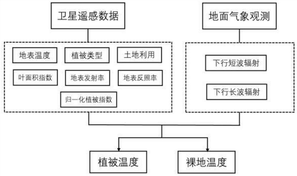
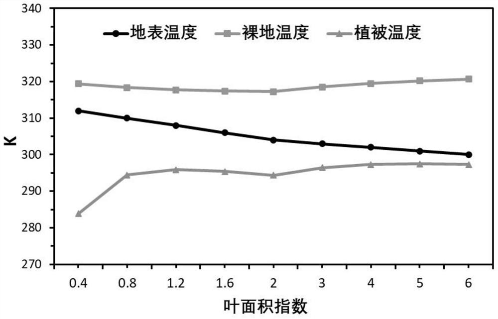
[0068] In this example, a mixed forest land in North China was taken as the research object, and the leaf area index, surface albedo, surface emissivity, surface temperature, etc. of 9 pixels of MOIDS satellite remote sensing data in June 2019 and the downlink of meteorological observations were taken. The short-wave radiation and the downlink long-wave radiation are used as the input data of the algorithm formula in the present invention, and the vegetation temperature and the bare ground temperature are calculated. The relationship between surface temperature, vegetation temperature and bare ground temperature with leaf area index figure 2 , whose details are shown in Table 1.

[0069] Table 1

[0070]

[0071] The above data show that the bare land temperature is higher than the surface temperature, while the vegetation temperature is lower than the surface temperature. The surface temperature decreased with the increase of LAI, and the vegetation temperature increase...


PUM


Abstract

The invention discloses a method for estimating vegetation temperature and bare ground temperature based on satellite remote sensing data, comprising the following steps: step 1, preparing satellite remote sensing data and ground meteorological observation data; step 2, calculating vegetation coverage according to the data in step 1; Step 3, calculate the albedo of bare land, emissivity of bare land and vegetation emissivity respectively according to the data in step 1; Step 4, calculate temperature of bare land and vegetation. The invention is based on the principle of surface energy balance, does not depend on other pixel information, and uses the satellite remote sensing data of the target pixel, including but not limited to surface temperature, surface emissivity, vegetation index, vegetation type and ground meteorological observation data as input , to calculate the vegetation temperature and bare ground temperature of the target pixel, which has spatial independence and improves the estimation accuracy.

Description

technical field [0001] The invention relates to a method for estimating vegetation temperature and bare ground temperature, belonging to the technical field of satellite remote sensing, in particular to a method for estimating vegetation temperature and bare ground temperature based on satellite remote sensing data. Background technique [0002] Land Surface Temperature (LST) or T L ) is characterized by the pixel scale, which only represents the average land surface temperature of the area covered by the pixel, and cannot distinguish the vegetation temperature and bare land temperature in the pixel with different vegetation coverage. [0003] Land Surface Temperature (LST) or T L ) characterizes the temperature state of the earth's land surface, and is a key variable in the surface energy balance and water cycle. It plays a very important role in the study of land-atmosphere interaction and climate change. All fields have important application value. The surface temperat...

Claims


Application Information

Patent Timeline
Patent Type & Authority Patents(China)
IPC IPC(8): G01J5/00G01N21/17
CPCG01J5/007G01N21/17G01N2021/1797
Inventor 张选泽张永强刘昌明
Owner INST OF GEOGRAPHICAL SCI & NATURAL RESOURCE RES CAS
Why Eureka
Try Eureka