

Forest resource monitoring method based on unmanned aerial vehicle aerial survey technology
A technology for forest resources and unmanned aerial vehicles, which is applied in the field of forest resources monitoring based on the aerial survey technology of unmanned aerial vehicles, can solve the problems of easily causing errors, requiring labor for individual trees, and lack of data comparison, so as to improve the accuracy and facilitate the Actual forest resource planning, data correspondence effect with high accuracy
- Summary
- Abstract
- Description
- Claims
- Application Information
AI Technical Summary
Problems solved by technology
Method used
Image


Examples
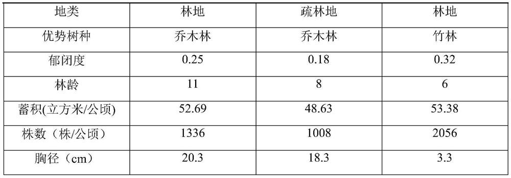
Embodiment 1
[0025] A kind of forest resource monitoring method based on unmanned aerial vehicle aerial survey technology of the present embodiment, the concrete monitoring method step is as follows:
[0026] S1: Take two-dimensional image data of all-round landform pictures of forest areas through remote sensing image technology, and obtain preliminary information of forest resources;
[0027] S2: The two-dimensional image data captured by remote sensing image technology is scanned and processed by CSS reading technology, and after processing, the coordinate model with the two-dimensional image data as the background and the center point of the two-dimensional image data as the coordinate origin is obtained, and the horizontal axis of the coordinate model is The distance between the axis and the vertical axis is 0.1km, and the positioning data of each monitoring point is designed on the coordinate model;
[0028] S3: The technicians control the drone's mobile shooting height. The drone us...
Embodiment 2
[0032] A kind of forest resource monitoring method based on unmanned aerial vehicle aerial survey technology of the present embodiment, the concrete monitoring method step is as follows:
[0033] S1: Take two-dimensional image data of all-round landform pictures of forest areas through remote sensing image technology, and obtain preliminary information of forest resources;
[0034] S2: The two-dimensional image data captured by remote sensing image technology is scanned and processed by CSS reading technology, and after processing, the coordinate model with the two-dimensional image data as the background and the center point of the two-dimensional image data as the coordinate origin is obtained, and the horizontal axis of the coordinate model is The distance between the axis and the vertical axis is 0.1km, and the positioning data of each monitoring point is designed on the coordinate model;
[0035] S3: The technician controls the drone’s mobile shooting height. The drone us...
Embodiment 3
[0039]A kind of forest resource monitoring method based on unmanned aerial vehicle aerial survey technology of the present embodiment, the concrete monitoring method step is as follows:
[0040] S1: Take two-dimensional image data of all-round landform pictures of forest areas through remote sensing image technology, and obtain preliminary information of forest resources;
[0041] S2: The two-dimensional image data captured by remote sensing image technology is scanned and processed by CSS reading technology, and after processing, the coordinate model with the two-dimensional image data as the background and the center point of the two-dimensional image data as the coordinate origin is obtained, and the horizontal axis of the coordinate model is The distance between the axis and the vertical axis is 0.1km, and the positioning data of each monitoring point is designed on the coordinate model;
[0042] S3: The technicians control the drone’s mobile shooting height. The drone use...
PUM
 Abstract
Description
Claims
Application Information