Pedestrian inertia SLAM method based on virtual landmark

A virtual landmark and virtual ground technology, applied in the field of pedestrian navigation, can solve the problems of unable to meet the long-term high-precision pedestrian navigation requirements, large cumulative errors, large noise, etc., and achieve the effect of improving reliable navigation time and reducing cumulative errors

Active Publication Date: 2021-06-15
NANJING UNIV OF AERONAUTICS & ASTRONAUTICS
View PDF7 Cites 4 Cited by
  • Summary
  • Abstract
  • Description
  • Claims
  • Application Information

AI Technical Summary

Problems solved by technology

[0003] At present, the low-cost inertial sensors commonly used in pure inertial pedestrian navigation systems have large noise, which will cause large cumulative errors when estimating the heading angle, and cannot meet the long-term high-precision pedestrian navigation requirements

Method used


Image

  • Pedestrian inertia SLAM method based on virtual landmark
  • Pedestrian inertia SLAM method based on virtual landmark
  • Pedestrian inertia SLAM method based on virtual landmark

Examples


Embodiment Construction

[0054] The technical solutions of the present invention will be further described below in conjunction with the accompanying drawings and embodiments.

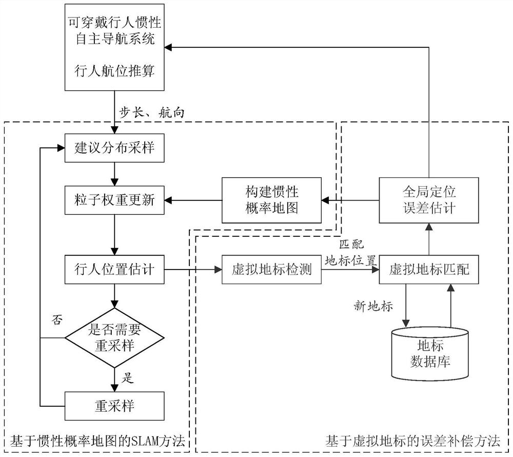
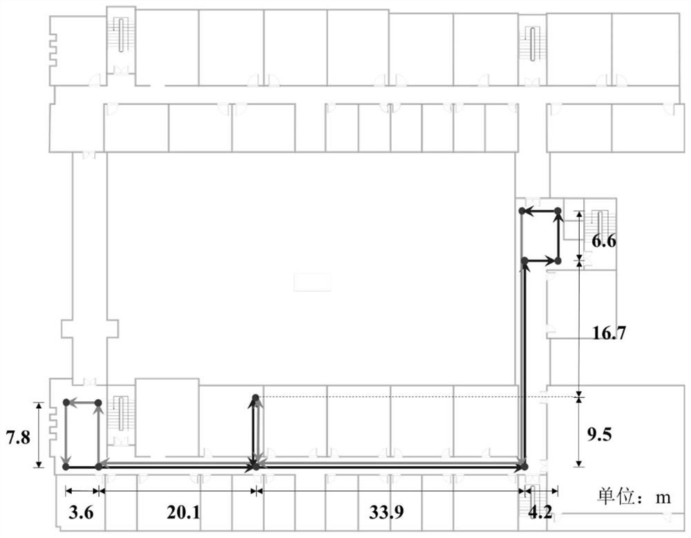
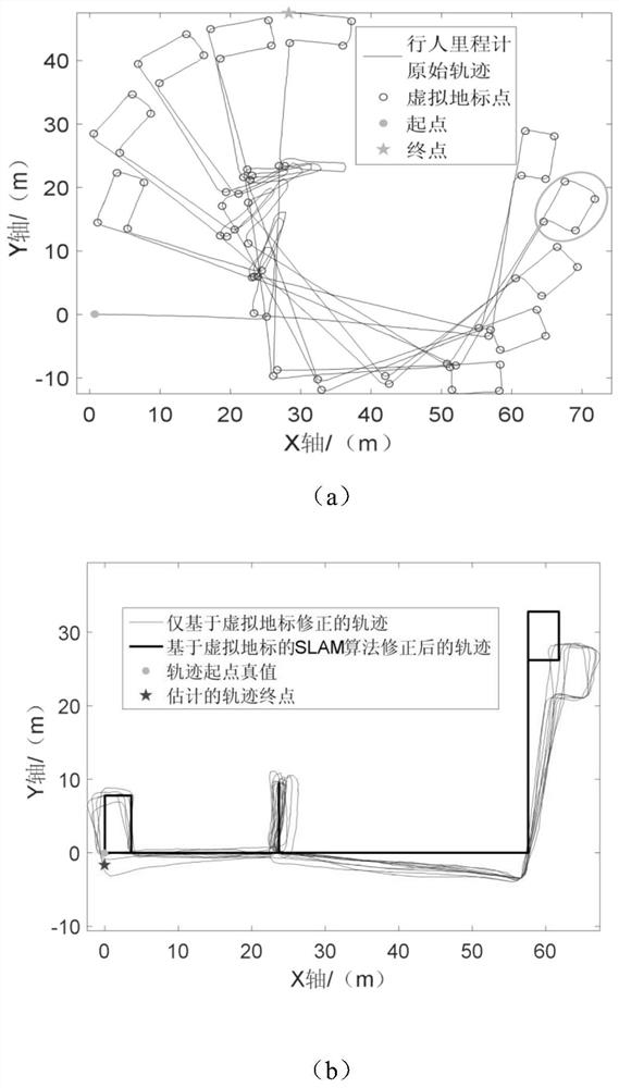
[0055] Such as figure 1 As shown, a pedestrian inertial SLAM method based on virtual landmarks includes the following steps:

[0056] Step 1, set the thresholds required by the algorithm, including the threshold φ for detecting the turning state 1 , virtual landmark screening distance threshold L pth1 , virtual landmark screening step interval threshold L sth1 , the virtual landmark matching distance threshold L pth2

[0057] Step 2, according to the error distribution p(E k |E k-1 ) for sampling, the error vector E k and the measurement vector Z output by the pedestrian odometer k Adding them to get the noisy gait vector U k .

[0058] u k = Z k +E k

[0059] Step 3, calculate the new pose of each particle according to the appropriate amount of gait,

[0060]

[0061] in is the position of the mth particle...


PUM


Abstract

The invention discloses a pedestrian inertia SLAM method based on a virtual landmark, and belongs to the technical field of pedestrian navigation methods. The pedestrian inertia SLAM method comprises the following steps of: firstly, identifying virtual landmark points in a pedestrian track according to information output by an inertial pedestrian odometer, performing error compensation on a position and a course by matching the virtual landmark points, then introducing an SLAM structure, constructing a hexagonal grid probability map and correcting position errors, and realizing simultaneous composition and positioning only based on an inertial sensor. According to the pedestrian inertia SLAM method, the problem that the course angle has accumulative errors when the pedestrian navigation system with a low-cost inertial sensor is used for estimating the course angle is solved, and high positioning precision is realized with small calculated amount.

Description

technical field [0001] The invention relates to a pedestrian inertial SLAM (simultaneous composition and positioning) method based on virtual landmarks, and belongs to the technical field of pedestrian navigation methods. Background technique [0002] With the rapid development of society, the demand for indoor pedestrian navigation systems in daily life and national defense is increasing day by day. At present, most of the more mature indoor navigation methods adopt the method of multi-information fusion. The pedestrian pose is obtained by combining information from different information sources such as inertial sensors, WIFI, UWB (ultra-wideband ranging technology), Bluetooth, and prior maps. However, other information sources except inertial sensors need to be arranged in advance or collected in advance to make a fingerprint library, which greatly restricts the autonomy of the pedestrian navigation system. Therefore, a pedestrian navigation system that only relies on ine...

Claims


Application Information

Patent Timeline
Patent Type & Authority Applications(China)
IPC IPC(8): G01C21/20G01C21/16G01C21/14
CPCG01C21/206G01C21/165G01C21/14
Inventor 曹志国熊智丁一鸣李婉玲王铮淳陈芷心李晓东李欣童安竞轲
Owner NANJING UNIV OF AERONAUTICS & ASTRONAUTICS
Why Eureka
Try Eureka