Method for monitoring salt content of salinized soil on earth surface under vegetation coverage

A technology of vegetation coverage and salt content, which is applied in measurement devices, scattering characteristic measurement, radio wave measurement systems, etc., can solve problems such as affecting the accuracy of satellite inversion of saline soil, and achieve the effect of high inversion accuracy

Pending Publication Date: 2021-06-22
NORTHEAST INST OF GEOGRAPHY & AGRIECOLOGY C A S
View PDF8 Cites 1 Cited by
  • Summary
  • Abstract
  • Description
  • Claims
  • Application Information

AI Technical Summary

Problems solved by technology

[0005] In order to solve the problem that vegetation affects the accuracy of satellite inversion of saline soil, the present invention provides a method for monitoring the salinity of saline soil on the surface covered by vegetation

Method used


Image

  • Method for monitoring salt content of salinized soil on earth surface under vegetation coverage
  • Method for monitoring salt content of salinized soil on earth surface under vegetation coverage
  • Method for monitoring salt content of salinized soil on earth surface under vegetation coverage

Examples


specific Embodiment approach 1

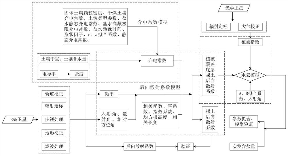
[0042] Specific implementation mode one: the monitoring method of the salinity of surface saline soil under vegetation cover in this implementation mode is carried out according to the following steps:

[0043] Step 1. Prepare SAR radar images and optical satellite images of the study area;

[0044] Step 2. Obtain radar and optical satellite parameters respectively according to the SAR radar image and optical satellite image in step 1, and then use the normalized difference moisture index NDWI to invert the vegetation water content;

[0045] Step 3, using the saline soil dielectric constant model to simulate the complex dielectric constant of saline soil, the saline soil dielectric constant model is expressed as:

[0046]

[0047]

[0048] Among them, ρ b is soil bulk density; S is the salt content of saline soil; m v is the volumetric water content of the soil;

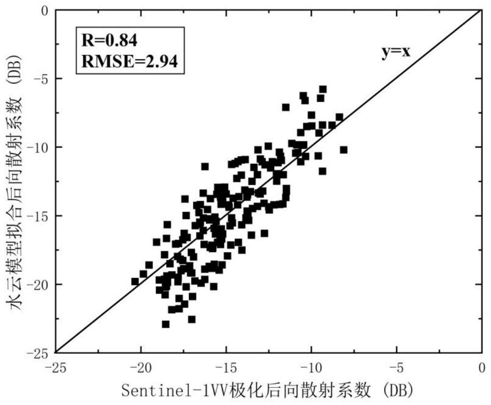
[0049] Step 4, input the complex permittivity into the improved integral equation (AIEM) model to simulat...

Embodiment 1

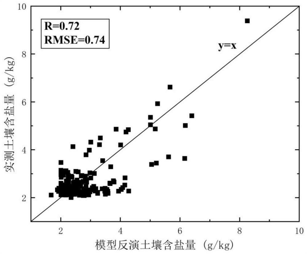
[0077] Example 1 takes the inversion of salinity in saline soil in western Jilin Province as an example.

[0078] The monitoring method of the salinity content of saline soil on the surface under vegetation cover is carried out according to the following steps:

[0079] Step 1. Prepare SAR radar images and optical satellite images of the study area;

[0080] Step 2. Obtain radar and optical satellite parameters respectively according to the SAR radar image and optical satellite image in step 1, and then use the normalized difference moisture index NDWI to invert the vegetation water content;

[0081] Step 3, using the saline soil dielectric constant model to simulate the complex dielectric constant of saline soil, the saline soil dielectric constant model is expressed as:

[0082]

[0083]

[0084] Among them, ρ s is the dry soil particle density; ρ b is soil bulk density; S (S represents the general formula) represents the salt content of saline soil; m v is the vol...


PUM


Abstract

The invention relates to a method for monitoring the salt content of salinized soil on earth surface, in particular to a method for monitoring the salt content of salinized soil on earth surface under vegetation coverage. According to the method, the problem that vegetation affects the precision of salinized soil satellite inversion is solved. The method comprises the following steps: preparing a radar image and an optical satellite image of a research area, obtaining satellite parameters, inverting the vegetation water content, simulating the complex dielectric constant of the salinized soil, inputting the complex dielectric constant into an improved integral equation model to simulate a radar image backscattering coefficient of the bare salinized soil, then constructing a water cloud model, taking the simulated bare soil backscattering coefficient as a bottom soil parameter of the water cloud model, coupling a dielectric constant model, an AIEM model and the water cloud model to obtain the radar image of the bare salinized soil, establishing a forward model of the salt content of the salinized soil under the remote sensing inversion vegetation coverage, and inverting the salt content of the salinized soil under the vegetation coverage through an optimal lookup table method. According to the method, the contribution of vegetation scattering to the overall back scattering of the salinized soil covered by vegetation is quantified, and the inversion precision is high.

Description

technical field [0001] The invention relates to a method for monitoring the salt content of surface saline soil. Background technique [0002] Saline-alkali land is a dynamically developing soil type. Timely information on the nature, scope, distribution, and salt content of saline soil is an important prerequisite for improving and controlling saline-alkali land and preventing further land degradation. Over the past few decades, satellite remote sensing has demonstrated its effectiveness in monitoring saline soils. However, soil salinization degraded areas mostly occur in farming and grazing areas and coastal areas, where there are often a large number of alkali-tolerant plants such as Suaeda salsa, Suaeda salsa, and reeds. Generally speaking, vegetation coverage can be used as an indicator of soil salinization, and as the degree of salinization increases, the proportion of vegetation coverage decreases. However, for some alkali-tolerant plants, appropriate salt accumulat...

Claims


Application Information

Patent Timeline
Patent Type & Authority Applications(China)
IPC IPC(8): G01S13/90G01N21/49G01N27/22
CPCG01S13/90G01N21/49G01N27/221
Inventor 董显聪李晓洁郑兴明
Owner NORTHEAST INST OF GEOGRAPHY & AGRIECOLOGY C A S
Why Eureka
Try Eureka