Supercharge Your Innovation With Domain-Expert AI Agents!

Satellite-borne GNSS-R sea ice boundary detection method and system

A detection method and satellite-borne technology, which can be used in radio wave measurement systems, satellite radio beacon positioning systems, measurement devices, etc., and can solve the problems of low detection accuracy and complex calculation process.

Pending Publication Date: 2021-06-25
BEIHANG UNIV
View PDF3 Cites 0 Cited by
  • Summary
  • Abstract
  • Description
  • Claims
  • Application Information

AI Technical Summary

Problems solved by technology

[0004] However, in the process of sea ice boundary detection using the existing spaceborne GNSS-R technology, there are problems such as low detection accuracy and complicated calculation process.

Method used


Image

  • Satellite-borne GNSS-R sea ice boundary detection method and system
  • Satellite-borne GNSS-R sea ice boundary detection method and system
  • Satellite-borne GNSS-R sea ice boundary detection method and system

Examples


Embodiment Construction

[0057] The following will clearly and completely describe the technical solutions in the embodiments of the present invention with reference to the accompanying drawings in the embodiments of the present invention. Obviously, the described embodiments are only some, not all, embodiments of the present invention. Based on the embodiments of the present invention, all other embodiments obtained by persons of ordinary skill in the art without making creative efforts belong to the protection scope of the present invention.

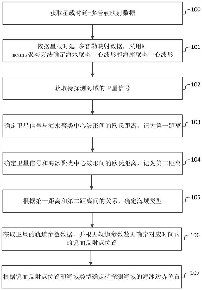
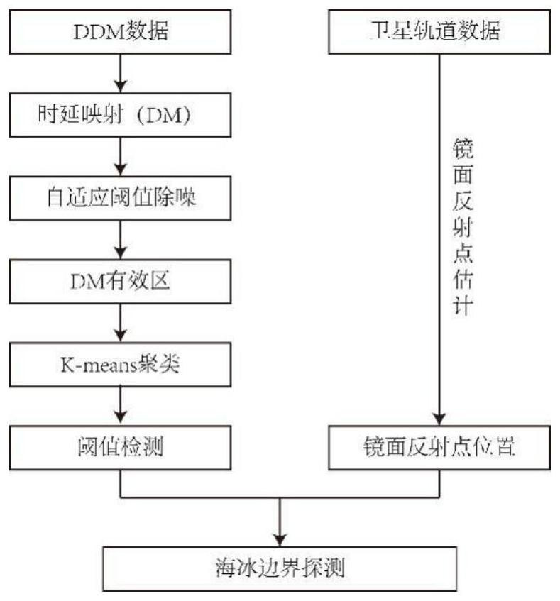
[0058] The purpose of the present invention is to provide a spaceborne GNSS-R sea ice boundary detection method and system with the characteristics of simple algorithm, suitable for carrying on the spaceborne platform, and high detection accuracy.

[0059] In order to make the above objects, features and advantages of the present invention more comprehensible, the present invention will be further described in detail below in conjunction with the accompanying dra...


PUM


Abstract

The invention relates to a satellite-borne GNSS-R sea ice boundary detection method and system. According to the satellite-borne GNSS-R sea ice boundary detection method, a K-means clustering method is adopted to determine a sea water clustering center waveform and a sea ice clustering center waveform according to satellite-borne time delay-Doppler mapping data, after a satellite signal of a sea area to be detected is obtained, the Euclidean distances between the satellite signal and the sea water and sea ice clustering center waveforms are determined, then the sea area type is determined according to the determined relationship between the Euclidean distances, and finally, the sea ice boundary position of the sea area to be detected is determined according to the obtained specular reflection point position and the sea area type, so that the whole detection process has the characteristics of simple algorithm, high detection precision and the like.

Description

technical field [0001] The present invention relates to the technical field of marine monitoring, in particular to a spaceborne GNSS-R sea ice boundary detection method and system, specifically a spaceborne GNSS-R sea ice boundary detection based on the K-means clustering algorithm methods and systems. Background technique [0002] The use of GNSS reflected signals for ocean remote sensing is one of the new technologies of satellite remote sensing technology, which has the advantages of multiple sources, light weight, spread spectrum processing, and wide application area. GNSS-Reflected (Global Navigation Satellite system-Reflected, GNSS-R) technology uses shore-based, airborne and airborne special receiving equipment to receive GNSS direct signals and echo signals scattered by reflective surfaces, and obtain The two-dimensional relative power of the reflected signal corresponding to the time-delay Doppler unit in the reflecting surface, and then obtain the physical paramet...

Claims


Application Information

Patent Timeline
IPC IPC(8): G01S19/14G01S13/88G01S13/95G06K9/62
CPCG01S19/14G01S13/885G01S13/955G06F18/23213Y02A90/10
Inventor 杨东凯张国栋王峰
Owner BEIHANG UNIV
Features
  • R&D
  • Intellectual Property
  • Life Sciences
  • Materials
  • Tech Scout
  • Unparalleled Data Quality
  • Higher Quality Content
  • 60% Fewer Hallucinations
Learn More