Unmanned aerial vehicle height setting algorithm based on multi-sensor fusion

A multi-sensor fusion and UAV technology, which is applied in the field of UAV altitude determination algorithm based on multi-sensor fusion, can solve the problems of absolute error, high barometric pressure measurement, and low accuracy

Pending Publication Date: 2021-07-06
SUQIAN COLLEGE
View PDF2 Cites 0 Cited by
  • Summary
  • Abstract
  • Description
  • Claims
  • Application Information

AI Technical Summary

Problems solved by technology

However, in the low-altitude stage of takeoff and landing, there is a certain amount of airflow, which will cause a relatively large absolute error in the height measured by the barometer, and the accuracy is not high.

Method used


Image

  • Unmanned aerial vehicle height setting algorithm based on multi-sensor fusion
  • Unmanned aerial vehicle height setting algorithm based on multi-sensor fusion
  • Unmanned aerial vehicle height setting algorithm based on multi-sensor fusion

Examples


Embodiment 1

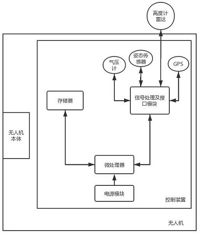
[0063] like figure 1 As shown, a drone based on multi-sensor fusion includes a drone body and a control device arranged in the drone body, the control device includes a microprocessor, and a power supply connected to the microprocessor, memory, a signal processing and interface module and a plurality of height sensors; the height measuring unit in the signal processing and interface module includes a validity judgment unit, a height data acquisition unit, a height alignment unit and a fusion calculation unit;

[0064] The plurality of sensors used to measure altitude include: altimeter radar, barometer and GPS altitude sensor, and the corresponding effective altitude includes radar altitude, barometric altitude and GPS altitude; Only by correcting can the accurate radar height be obtained;

[0065] The correction unit is connected with the altimeter radar and the attitude sensor to correct the measured radar height;

[0066] The validity judging unit is connected with each h...

Embodiment 2

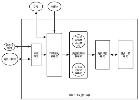
[0071] like Figure 2-3 As shown, a UAV altitude determination algorithm based on multi-sensor fusion includes a UAV body and a control device arranged in the UAV body, and the control device includes a plurality of sensors for measuring height.


PUM


Abstract

The invention discloses an unmanned aerial vehicle height setting algorithm based on multi-sensor fusion. The algorithm comprises an unmanned aerial vehicle body and a control device arranged in the unmanned aerial vehicle body, the control device comprises a power supply, a microprocessor, a memory, a signal processing and interface module and a plurality of sensors for measuring height; data measured by a plurality of sensors used for height measurement are fused, unavailable height data are automatically removed during fusion, available height data are substituted into a formula for fusion calculation, and more accurate and reliable height information is obtained. The algorithm overcomes the limitations of large measurement error, complex programming and the like in the prior art, has the advantages of easy understanding of the principle and device of the used knowledge points, small calculation amount, strong real-time performance and the like, and has obvious application value in the field of height measurement of the unmanned aerial vehicle.

Description

technical field [0001] The invention relates to the technical field of unmanned aerial vehicle height measurement, and in particular relates to an algorithm for determining the height of an unmanned aerial vehicle based on multi-sensor fusion. Background technique [0002] Rotor UAV is a typical underactuated system with multi-variable, strong coupling, nonlinear and other characteristics, and involves many disciplines, a wide range of fields, and complex states during flight. Based on the above problems, it is very difficult to measure the height of the rotor UAV. [0003] Most of the existing UAV altimetry sensor systems use GPS, barometer, laser, accelerometer and other sensors to obtain height information. However, because each sensor has its own shortcomings, the height data obtained by the drone is not accurate. The altitude information of the UAV can be obtained by measuring the current air pressure through the barometer, or can be directly read through the GPS, and...

Claims


Application Information

Patent Timeline
IPC IPC(8): G01C5/06G01S13/88
CPCG01C5/06G01C5/005G01S13/882
Inventor 葛海浪许茜王鑫鑫李光宇许俊张锦陈国彬唐友亮
Owner SUQIAN COLLEGE
Why Eureka
Try Eureka