A method for identification and traceability of hazardous waste illegal dumping risk areas based on multi-source data
A hazardous waste and multi-source data technology, applied in data processing applications, geographic information databases, structured data retrieval, etc., can solve problems such as environmental risks, insufficient awareness of responsibilities, long chain of supervision, etc., and achieve the effect of narrowing the scope of supervision
- Summary
- Abstract
- Description
- Claims
- Application Information
AI Technical Summary
Problems solved by technology
Method used
Image
Examples
Embodiment 1
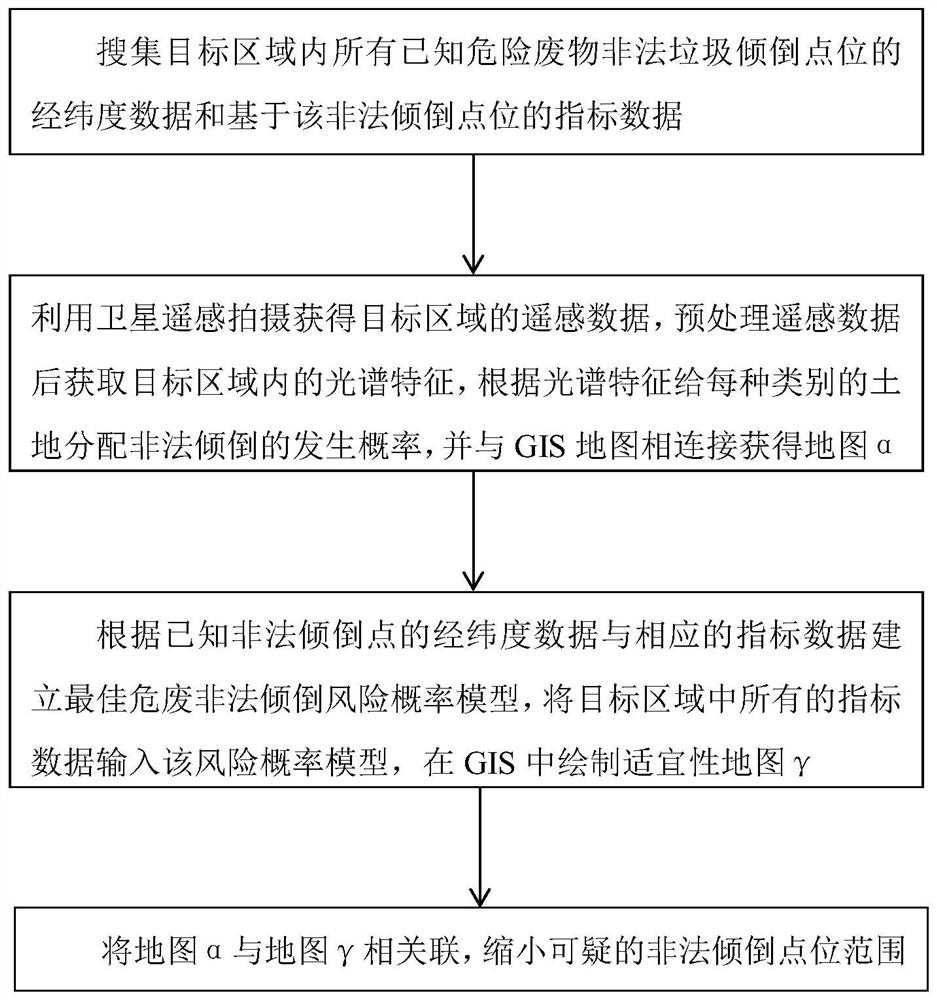
[0034] Such as figure 1 As shown, a method for identifying risky areas of illegal dumping of hazardous waste based on multi-source data, the method includes:
[0035] Step 1: Collect the latitude and longitude data of all known hazardous waste illegal dumping sites in the target area and the index data based on the illegal dumping sites;
[0036] Step 2: Use satellite remote sensing to obtain remote sensing data of the target area, preprocess the remote sensing data to obtain the spectral characteristics in the target area, assign the probability of illegal dumping to each type of land according to the spectral characteristics, and connect it with the GIS map to obtain map alpha;
[0037] Step 3: Based on the latitude and longitude data of known illegal dumping points and the corresponding index data, establish the optimal risk probability model of illegal dumping of hazardous waste, input all the index data in the target area into the risk probability model, and draw a suita...
Embodiment 2
[0097] Such as Figure 4 As shown, the method also includes step 5: using a drone to take aerial photos of the determined suspicious illegal dumping point range, and inputting the extracted image into a Bayesian classifier to automatically distinguish between illegal dumping points and places where illegal dumping has not occurred. area.
[0098] see Figure 5 , including the following steps:
[0099] Step 5-1, choose a suitable UAV, and install a digital camera with appropriate precision on the UAV. At the same time, considering that some illegal dumping sites of hazardous waste are covered with soil, it is possible to install an infrared thermal imaging camera on the UAV to observe.
[0100] Step 5-2, use the UAV to check N in step 4-2 1 The area of suspicious illegal dumping site of hazardous waste explored by UAV is n i , a set of pictures obtained by using UAV to shoot the area is denoted as A{a 1 、a 2 、a 3 …a n}, in addition, a set of atlases recorded by the i...
Embodiment 3
[0116] Such as Figure 6 As shown, the method further includes step 6: conducting on-the-spot investigation on the illegal dumping point area determined by the automatic distinction, and the investigation content includes whether there is illegal dumping, hazardous waste material category and label identification information.
[0117] Specifically include the following steps:
[0118] Conduct on-the-spot investigation on the suspected hazardous waste illegal dumping point R obtained in step 5. There are three possibilities in the investigation results, (a) there is no illegal dumping in the R domain; (b) there is illegal dumping of hazardous waste in the R domain, and the information of the relevant waste production units can be queried on the hazardous waste; (c) the R domain There is illegal dumping of hazardous waste, but no information on the relevant waste-producing units can be found on the hazardous waste product.
[0119] Such as Figure 7 As shown, a method for tra...
PUM
 Abstract
Description
Claims
Application Information
 - R&D
- Intellectual Property
- Life Sciences
- Materials
- Tech Scout
- Unparalleled Data Quality
- Higher Quality Content
- 60% Fewer Hallucinations
Browse by: Latest US Patents, China's latest patents, Technical Efficacy Thesaurus, Application Domain, Technology Topic, Popular Technical Reports.
© 2025 PatSnap. All rights reserved.Legal|Privacy policy|Modern Slavery Act Transparency Statement|Sitemap|About US| Contact US: help@patsnap.com


